

North Chelmsford, Massachusetts
Encyclopedia
Unincorporated area
In law, an unincorporated area is a region of land that is not a part of any municipality.To "incorporate" in this context means to form a municipal corporation, a city, town, or village with its own government. An unincorporated community is usually not subject to or taxed by a municipal government...
village in the town of Chelmsford
Chelmsford, Massachusetts
Chelmsford is a suburban town in Middlesex County, Massachusetts in the Greater Boston area. As of the 2010 United States Census, the town's population was 33,802. The Census Bureau's 2008 population estimate for the town was 34,409, ranking it 14th in population among the 54 municipalities in...
, Massachusetts
Massachusetts
The Commonwealth of Massachusetts is a state in the New England region of the northeastern United States of America. It is bordered by Rhode Island and Connecticut to the south, New York to the west, and Vermont and New Hampshire to the north; at its east lies the Atlantic Ocean. As of the 2010...
, United States
United States
The United States of America is a federal constitutional republic comprising fifty states and a federal district...
. Although North Chelmsford has its own zip code (01863), library, post office, police station, fire station, and local calling area, it is run by the same local town government and is part of the same school district as Chelmsford.
North Chelmsford is more industrial, more densely populated, and generally less affluent than the rest of Chelmsford. North Chelmsford's separate identity and the town government's perceived bias one way or the other is a political issue - the Lowell Sun
Lowell Sun
The Sun is a daily newspaper based in Lowell, Massachusetts, United States, serving towns in Massachusetts and New Hampshire in the Greater Lowell area and beyond. Its circulation is about 50,000...
ran an article on August 7, 2005 describing the situation as "Chelmsford's Civil War Still Raging On." Bumper stickers such as "I'm from North Chelmsford - Don't Tread On Me" can be seen around town.
Education
Chelmsford High School is located in North Chelmsford. The students who live in North Chelmsford go to Harrington Elementary School or Westlands Elementary School, and Parker Middle School.Geography
North Chelmsford is along the Merrimack RiverMerrimack River
The Merrimack River is a river in the northeastern United States. It rises at the confluence of the Pemigewasset and Winnipesaukee rivers in Franklin, New Hampshire, flows southward into Massachusetts, and then flows northeast until it empties into the Atlantic Ocean at Newburyport...
and Stony Brook. Freeman Lake, originally on maps as Newfield Pond, or as it used to be known, Crystal Lake due to an ice company named the same that used to be located where the dam is today, is located on Route 40, a short distance from Vinal Square. It is also the site of the Chelmsford Senior Center.
North Chelmsford is centered around the intersection of 3A, 40
Route 40 (Massachusetts)
Route 40 is a 10.5-mile east–west state route located in northeastern Massachusetts, entirely within Middlesex County. The short highway connects Groton and Chelmsford. Its western end is at an intersection with Massachusetts Route 119 and Massachusetts Route 225 in Groton, and its eastern...
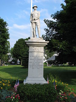
, and a few local roads. This intersection is known as Vinal Square, after local World War I
World War I
World War I , which was predominantly called the World War or the Great War from its occurrence until 1939, and the First World War or World War I thereafter, was a major war centred in Europe that began on 28 July 1914 and lasted until 11 November 1918...
Private Alberton W. Vinal, who was killed in France. A stone monument is dedicated to him and Chelmsford's other World War I fatalities on the Square's common.
Transportation
U.S. Route 3U.S. Route 3
U.S. Route 3 is a north–south United States highway that runs from its southern terminus in Cambridge, Massachusetts through New Hampshire to its terminus near Third Connecticut Lake at the Canadian border, where the road continues north as Quebec Route 257.In New Hampshire parts of US 3 are...
has two signed North Chelmsford exits - one for Route 40 (Exit 33), the other for Drum Hill (Exit 32).
A Massachusetts Bay Transportation Authority
Massachusetts Bay Transportation Authority
The Massachusetts Bay Transportation Authority, often referred to as the MBTA or simply The T, is the public operator of most bus, subway, commuter rail and ferry systems in the greater Boston, Massachusetts, area. Officially a "body politic and corporate, and a political subdivision" of the...
commuter rail station will be located in North Chelmsford if/when the proposed extension of the Lowell
Lowell, Massachusetts
Lowell is a city in Middlesex County, Massachusetts, USA. According to the 2010 census, the city's population was 106,519. It is the fourth largest city in the state. Lowell and Cambridge are the county seats of Middlesex County...
Line to Nashua, New Hampshire
Nashua, New Hampshire
-Climate:-Demographics:As of the census of 2010, there were 86,494 people, 35,044 households, and 21,876 families residing in the city. The population density was 2,719.9 people per square mile . There were 37,168 housing units at an average density of 1,202.8 per square mile...
is completed.