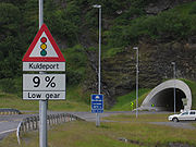
North Cape Tunnel
Encyclopedia

Tunnel
A tunnel is an underground passageway, completely enclosed except for openings for egress, commonly at each end.A tunnel may be for foot or vehicular road traffic, for rail traffic, or for a canal. Some tunnels are aqueducts to supply water for consumption or for hydroelectric stations or are sewers...
under Magerøysundet from the Norwegian
Norway
Norway , officially the Kingdom of Norway, is a Nordic unitary constitutional monarchy whose territory comprises the western portion of the Scandinavian Peninsula, Jan Mayen, and the Arctic archipelago of Svalbard and Bouvet Island. Norway has a total area of and a population of about 4.9 million...
mainland to Magerøya
Magerøya
Magerøya is an island in Finnmark county in the extreme north of Norway, in the community of Nordkapp. The island features a bleak, barren tundra-landscape devoid of any trees , with steep cliff faces on the coast and dramatic mountainscapes in the interior. It has an area of...
. The tunnel was built between 1993 and 1999, is 6875 metres (22,555.8 ft) long, and reaches a depth of 212 metres (695.5 ft) below the sea level. Before the tunnel was built, a ferry
Ferry
A ferry is a form of transportation, usually a boat, but sometimes a ship, used to carry primarily passengers, and sometimes vehicles and cargo as well, across a body of water. Most ferries operate on regular, frequent, return services...
carried the traffic across the sea between Kåfjord
Kåfjord, Nordkapp
Kåfjord is a village in the municipality of Nordkapp, in the county of Finnmark, Norway. It is located on the mainland on an arm of the Magerøysundet....
and Honningsvåg
Honningsvåg
at 70° 58' N, in Nordkapp municipality, claims to be the northernmost city in Norway and even in the world, although the title is disputed by Hammerfest, Norway; Barrow, Alaska; and Longyearbyen, Svalbard...
.
The tunnel takes its name from North Cape
North Cape, Norway
North Cape is a cape on the island of Magerøya in Northern Norway, in the municipality of Nordkapp. Its 307 m high, steep cliff is often referred to as the northernmost point of Europe, located at , 2102.3 km from the North Pole. However, the neighbouring point Knivskjellodden is actually...
at the very north of Magerøya island. North Cape Tunnel is part of European route E69
European route E69
European route E 69 is an E-road between Olderfjord and North Cape in northern Norway. The road is long. It contains five tunnels, totalling...
. The charge for passing through the tunnel in 2011 is 145 NOK for a car plus an additional 47 NOK per adult and 24 per child. The fee is one-way and is charged also on the return trip. As of 2010, it is possible to cycle through the tunnel free of charge.
The tunnel has anti-freezing gates (Norwegian: Kuldeport) which close the mouths of the tunnel in the winter to avoid freezing of leaking water. These gates open automatically when cars approach and are permanently open in the summer, when traffic is denser.
- Location, southern end: 70°53′30"N 25°41′00"E
- Location, northern end: 70°57′00"N 25°42′20"E

