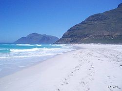
Noordhoek, Cape Town
Encyclopedia

Cape Town
Cape Town is the second-most populous city in South Africa, and the provincial capital and primate city of the Western Cape. As the seat of the National Parliament, it is also the legislative capital of the country. It forms part of the City of Cape Town metropolitan municipality...
, South Africa
South Africa
The Republic of South Africa is a country in southern Africa. Located at the southern tip of Africa, it is divided into nine provinces, with of coastline on the Atlantic and Indian oceans...
, located below Chapman's Peak
Chapman's Peak
Chapman's Peak is the name of a mountain on the western side of the Cape Peninsula, about 15 kilometres south of Cape Town, South Africa. It is opposite the inlet on which the town of Hout Bay is centred....
on the west coast of the Cape Peninsula
Cape Peninsula
The Cape Peninsula is a generally rocky peninsula that juts out for 75 km into the Atlantic Ocean at the south-western extremity of the African continent. At the southern end of the peninsula are Cape Point and the Cape of Good Hope...
, approximately thirty-five kilometres to the south of the city itself. The name "Noordhoek" was taken from Dutch
Dutch language
Dutch is a West Germanic language and the native language of the majority of the population of the Netherlands, Belgium, and Suriname, the three member states of the Dutch Language Union. Most speakers live in the European Union, where it is a first language for about 23 million and a second...
and literally means "north corner". It is best-known for its picturesque shoreline and its long, wide, sandy beach, which stretches south to the neighbouring village of Kommetjie. Near the southern end of this beach is the wreck of the steamship "Kakapo", which ran aground about a century ago when the captain mistook Chapmans' Peak for the Cape of Good Hope
Cape of Good Hope
The Cape of Good Hope is a rocky headland on the Atlantic coast of the Cape Peninsula, South Africa.There is a misconception that the Cape of Good Hope is the southern tip of Africa, because it was once believed to be the dividing point between the Atlantic and Indian Oceans. In fact, the...
and put the helm over to port.
Noordhoek can be accessed either from the spectacular scenic coastal road, Chapman's Peak Drive, which leads out of Hout Bay or via the mountain road Ou Kaapse Weg which cuts through the beautiful Silvermine Nature reserve - now part of the Table Mountain National Park. Noordhoek is a small scattered community of nice houses, often with sea views and has a large horse population as riding on the long sandy beach is a great attraction. Many artists live in Noordhoek.

