
Noatak River
Encyclopedia

River
A river is a natural watercourse, usually freshwater, flowing towards an ocean, a lake, a sea, or another river. In a few cases, a river simply flows into the ground or dries up completely before reaching another body of water. Small rivers may also be called by several other names, including...
in northwestern Alaska
Alaska
Alaska is the largest state in the United States by area. It is situated in the northwest extremity of the North American continent, with Canada to the east, the Arctic Ocean to the north, and the Pacific Ocean to the west and south, with Russia further west across the Bering Strait...
. The river's headwaters are on 8570 feet (2,612.1 m) tall Mount Igikpak
Mount Igikpak
Mount Igikpak is the highest peak in the Schwatka Mountains region of the Brooks Range. It is also the tallest mountain in Gates of the Arctic National Park, located in the US state of Alaska. Some sources list the height of its summit at 8,510'...
in the Schwatka Mountains of the Brooks Range
Brooks Range
The Brooks Range is a mountain range in far northern North America. It stretches from west to east across northern Alaska and into Canada's Yukon Territory, a total distance of about 1100 km . The mountains top out at over 2,700 m . The range is believed to be approximately 126 million years old...
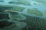
in the Gates of the Arctic National Park. The Noatak flows generally westward approximately 675 km (419.4 mi) to the Chukchi Sea
Chukchi Sea
Chukchi Sea is a marginal sea of the Arctic Ocean. It is bounded on the west by the De Long Strait, off Wrangel Island, and in the east by Point Barrow, Alaska, beyond which lies the Beaufort Sea. The Bering Strait forms its southernmost limit and connects it to the Bering Sea and the Pacific...
at Kotzebue Sound
Kotzebue Sound
Kotzebue Sound is an arm of the Chukchi Sea in the western region of the U.S. state of Alaska. It is on the north side of the Seward Peninsula and bounded the east by the Baldwin Peninsula. It is long and wide....
. The river's entire course is north of the Arctic Circle
Arctic Circle
The Arctic Circle is one of the five major circles of latitude that mark maps of the Earth. For Epoch 2011, it is the parallel of latitude that runs north of the Equator....
. Leaving Gates of the Arctic National Park the river enters the Noatak National Preserve
Noatak National Preserve
The Noatak National Preserve is an United States National Preserve in northwestern Alaska that was established to protect the Noatak River Basin...
which exactly delineates the river's watershed. The entire watershed of the Noatak River, not just the river itself, lies within these two protected areas, from the headwaters to where it leaves the Noatak National Preserve, which is a point approximately 20 river-miles upstream of Noatak village and 90 river-miles upstream of the river's delta in Kotzebue Sound. Even on this last part of the river most of the watershed lies within either Noatak National Preserve or Cape Krusenstern National Monument
Cape Krusenstern National Monument
Cape Krusenstern National Monument and the colocated Cape Krusenstern Archeological District is a U.S. National Monument and a National Historic Landmark centered on Cape Krusenstern in northwestern Alaska....
, with only the immediate river valley outside of these protected areas. This is the largest protected watershed basin in the U.S. The Noatak National Preserve alone encompasses 6500000 acres (26,304.6 km²).
There are small inholdings of private land within the National Preserve, some of these have private cabins.
The only permanent settlement along the Noatak River is the village of Noatak
Noatak, Alaska
Noatak is an a census-designated place in the Northwest Arctic Borough in the U.S. state of Alaska. The population was 428 at the 2000 census. It is served by Noatak Airport.- History :...
. The village has a 4000 feet (1,219.2 m) lighted public gravel airstrip, several small stores, post office, and a school.
The Noatak is fed by a relatively large watershed: as for some other large braided Arctic rivercourses, rare severe rain events can result in temporary rapid inundation, to a depth of several feet, of normally dry river bars. There are a few small remnant glaciers in the Schwatka Mountains, their contribution to the water budget of the Noatak is negligble.
The early English name "Inland River" published by surgeon John Simpson, RN, on his 1853 "Native Map," appears to be a general translation of the Inuit
Inuit
The Inuit are a group of culturally similar indigenous peoples inhabiting the Arctic regions of Canada , Denmark , Russia and the United States . Inuit means “the people” in the Inuktitut language...
name "Nunulak" which he also recorded. The name "Nunatak" could also mean "new land" or "belong to the land."
Wild and Scenic River
On December 2, 1980, the 330 miles (531.1 km) of the Noatak - from its source in Gates of the Arctic National Park to the Kelly River in the Noatak National Preserve - were designated a National Wild and Scenic RiverNational Wild and Scenic River
National Wild and Scenic River is a designation for certain protected areas in the United States.The National Wild and Scenic Rivers Act was an outgrowth of the recommendations of a Presidential commission, the Outdoor Recreation Resources Review Commission...
.