

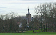
Nil-Saint-Vincent-Saint-Martin
Encyclopedia
Walloon Brabant
Walloon Brabant is a province of Wallonia in Belgium. It borders on the province of Flemish Brabant and the provinces of Liège, Namur and Hainaut . Its capital is Wavre...
, Belgium
Belgium
Belgium , officially the Kingdom of Belgium, is a federal state in Western Europe. It is a founding member of the European Union and hosts the EU's headquarters, and those of several other major international organisations such as NATO.Belgium is also a member of, or affiliated to, many...
. In 1976 it became part of the municipality of Walhain
Walhain
Walhain is a Walloon municipality of Belgium located in the province of Walloon Brabant. It consists of the former municipalities of Nil-Saint-Vincent-Saint-Martin, Tourinnes-Saint-Lambert and Walhain-Saint-Paul....
.
The villages of Nil-Saint-Vincent and Nil-Saint-Martin were merged in 1812. 'Nil' is the name of a small river, along whose valley the various areas of settlement (Nil-Pierreux, Nil-Saint-Vincent, Nil-Saint-Martin) lie.
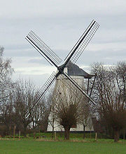
The Tiège windmill
The Tiège windmill was built in 1834 by the Thienpont family. It was used until June 23, 1946 and today is a listed building (monument classé).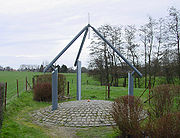
The centre of Belgium
The Institut Géographique NationalBelgian National Geographic Institute
The Belgian National Geographic Institute is the national mapping agency in Belgium.The headquarters are located at La Cambre Abbey in Brussels....
, the Belgian national cartographical service, calculated that the geographical centre
Geographical centre
In geography, the centroid of the two-dimensional shape of region of the Earth's surface is often known as its geographical centre. There has long been debate over the methods of calculation of the geographical centres of various countries and regions, such as whether to include offshore islands,...
of Belgium lay in Nil-Saint-Vincent.
The architect Bernard Defrenne built a monument for this location, which was inaugurated on August 22, 1998.
It is located at coordinates 50°38′28"N 4°40′05"E.