

Niangua River
Encyclopedia
Tributary
A tributary or affluent is a stream or river that flows into a main stem river or a lake. A tributary does not flow directly into a sea or ocean...
of the Osage River
Osage River
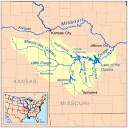
The Osage River is a tributary of the Missouri River in central Missouri in the United States. The Osage River is one of the larger rivers in Missouri. The river drains a mostly rural area of . The watershed includes an area of east-central Kansas and a large portion of west-central and central...
in the Ozarks region of southern and central Missouri
Missouri
Missouri is a US state located in the Midwestern United States, bordered by Iowa, Illinois, Kentucky, Tennessee, Arkansas, Oklahoma, Kansas and Nebraska. With a 2010 population of 5,988,927, Missouri is the 18th most populous state in the nation and the fifth most populous in the Midwest. It...
in the United States
United States
The United States of America is a federal constitutional republic comprising fifty states and a federal district...
. Via the Osage and Missouri
Missouri River
The Missouri River flows through the central United States, and is a tributary of the Mississippi River. It is the longest river in North America and drains the third largest area, though only the thirteenth largest by discharge. The Missouri's watershed encompasses most of the American Great...
rivers it is part of the watershed
Drainage basin
A drainage basin is an extent or an area of land where surface water from rain and melting snow or ice converges to a single point, usually the exit of the basin, where the waters join another waterbody, such as a river, lake, reservoir, estuary, wetland, sea, or ocean...
of the Mississippi River
Mississippi River
The Mississippi River is the largest river system in North America. Flowing entirely in the United States, this river rises in western Minnesota and meanders slowly southwards for to the Mississippi River Delta at the Gulf of Mexico. With its many tributaries, the Mississippi's watershed drains...
.
Course
The Niangua River is formed in Webster CountyWebster County, Missouri
Webster County is a county located in Southwest Missouri. As of 2000, the population was 31,045. The population in 2010 was 36,202. Its county seat is Marshfield. The county was organized in 1855 and named for U.S. Senator and U.S...
by the confluence of its short east and west forks, and flows generally northward through Dallas, Laclede
Laclede County, Missouri
Laclede County is a county located in the U.S. state of Missouri. As of 2000, the population was 32,513. Its county seat is Lebanon. The county was organized February 24, 1849, and was named after Pierre Laclède, founder of St...
and Camden
Camden County, Missouri
Camden County is a county located in the U.S. state of Missouri. As of 2000, the population was 37,051. Its county seat is Camdenton. The county was organized in 1841 as Kinderhook County and renamed in 1843, for Charles Pratt, 1st Earl Camden, Chancellor of England, and leader of the Whig...
counties, past Bennett Spring
Bennett Spring State Park
Bennett Spring State Park is located approximately 12 miles west of Lebanon, Missouri on Highway 64. The park was established in 1923. It is centered around the spring that flows into the Niangua River, that gives the park its name...
, Lake Niangua
Lake Niangua
Lake Niangua is a hydroelectric lake in southern Camden County, Missouri, USA, on the Niangua River. The lake has a public access with a boat ramp and picnic area.-History of the Tunnel Dam:...
, and Ha Ha Tonka
Ha Ha Tonka State Park
Ha Ha Tonka State Park is a state park in Missouri, United States, located near Camdenton on the Niangua arm of the Lake of the Ozarks. The area has several caves, sinkholes, and bluffs overlooking the lake. The most notable feature of the park is the stone ruins of a mansion, called "the...
State Parks. It flows into the Osage River as an arm of the Lake of the Ozarks
Lake of the Ozarks
The Lake of the Ozarks is a large reservoir created by impounding the Osage River in the northern part of the Ozarks in central Missouri. Extents of three smaller tributaries to the Osage, the Niangua River, Grandglaize Creek, and Gravois Creek, are included in the impoundment...
, which is formed by the Bagnell Dam
Bagnell Dam
Bagnell Dam impounds the Osage River in the U.S. state of Missouri, creating the Lake of the Ozarks. The 148-foot tall concrete gravity dam was built by the Union Electric Company for the purpose of hydroelectric power generation as its Osage Powerplant. It is long, including a long spillway...
on the Osage. As part of the lake it collects the Little Niangua River
Little Niangua River
The Little Niangua River is a tributary of the Niangua River in the Ozarks region of central Missouri in the United States. Via the Niangua, Osage and Missouri rivers, it is part of the watershed of the Mississippi River.- Description:...
.
River accesses
This is a list of areas where the Niangua River can be publicly accessed; this list was put in order from beginning of river to where river meets up with Lake of the Ozarks.- Charity Access- State-owned river access; no camping allowed.
- Cline Ford
- Hico Slab- Where a road crosses the river; the bridge is basically a low-lying concrete slab with water tunnels.
- Del Marlin Ford
- Deusenberry Creek
- Gaunt Ford
- Crane Ford
- Route 32 Bridge
- Big John Access- State-owned river access.
- Wimberly Ford
- Dallion Ford
- Hackler Ford
- Williams Ford Access- A one lane road crossing; crossing is a concrete slab where water flows over the top.
- Hwy. K-P Bridge Access- Access includes privately-owned campground, picnic area, and shuttle service.
- Moon Valley Access- State-owned river access.
- Hildebrand Ford
- Cat Hollow- Privately-owned campground and cabins nearby.
- Route 64 Bridge
- Bennett Spring Access- State-owned river access.
- Barclary Springs- State-owned river access.
- Gilbertson Ford
- Prosperine Access- State-owned river access.
- Mountain Creek- Access includes privately-owned campground, picnic area, cabins and shuttle service.
- McPheters Ford
- Smith Ford
- Leadmine Conservation Area- State-owned river access and conservation area; primitive camping allowed.
- Lake NianguaLake NianguaLake Niangua is a hydroelectric lake in southern Camden County, Missouri, USA, on the Niangua River. The lake has a public access with a boat ramp and picnic area.-History of the Tunnel Dam:...
- Includes access and picnic area; no camping allowed. - Whistle Bridge- Low-lying river crossing where road crosses river.
- Stone Ford
- Ha Ha Tonka State ParkHa Ha Tonka State ParkHa Ha Tonka State Park is a state park in Missouri, United States, located near Camdenton on the Niangua arm of the Lake of the Ozarks. The area has several caves, sinkholes, and bluffs overlooking the lake. The most notable feature of the park is the stone ruins of a mansion, called "the...
- State-owned river access; this is where the river merges into Lake of the Ozarks.