

Newton Township, Buchanan County, Iowa
Encyclopedia
Newton Township is one of sixteen townships
in Buchanan County
, Iowa
, USA
. As of the 2000 census
, its population was 423.
is in the northern portion of the township. Other settlements in the township from the late 19th and early 20th centuries are abandoned. According to the USGS
, Newton Township contains three cemeteries: Circle Grove, Saint Patrick's and Upper Spring Grove. Only Saint Patrick's of Monti is maintained.
.
Two cemeteries were established in the 1850s, one in the northern and one in the southern part of the township. A Catholic church and rectory
were constructed adjoining the northern cemetery in 1870. Newtonville was established in 1873, when a post office was built near the center of the township, at 42.347°N 91.675°W (Sections
16 and 17, see map on right). In 1875, the State Atlas of Iowa showed two churches, seven schools, and 19 houses in the township. Just 11 years later, in 1886, Warner and Foote's map of Newton Township showed 137 houses, ten schools, three churches, and two post offices in the township.
Many other small settlements sprang up, including Erin, Atlantic, and Monti. None of these communities ever incorporated. Atlantic was located at 42.311°N 91.685°W (Sections 28 and 33), and Erin at 42.369°N 91.600°W (Section 1). Monti was founded in 1885, on Buffalo Creek in the northern part of the township, at the location of the Catholic church (Sections 2 and 3). With the introduction of Rural Free Delivery in 1902, both the Newtonville and Monti post offices closed.
In 1911, the village of Kiene was founded 1.5 miles west of Monti at 42.384°N 91.661°W (Section 4), the result of a planned railway through the area. Kiene was named after Henry Kiene or Peter Kiene, presidents of the proposed rail line, who planned a rail route west from Dubuque toward Independence in 1903. The Chicago, Anamosa and Northern (CAN) Railway was built through Newton Township in 1912 and passed through both Kiene and Monti. Monti soon became a small but bustling community, with stores, a blacksmith shop, a bank, and a flag station. The old Newtonville Congregational Church was moved to Kiene in June 1914, and a new church was built at Newtonville. Kiene was a village of 25 residents in 1914; the populations of Newtonville and Monti were too small to report.
The post-World War I years saw a decline in the area's population. The CAN railroad was sold for scrap during World War II. The Newtonville, Erin, and Atlantic areas emptied. By 1955, the only structure remaining at Kiene was the church. The official 1956 school district map for Buchanan County shows only the locations of Kiene and Monti; by this time, the other villages were gone. The Kiene Congregational Church closed in 1970, its congregation merged into the Church of Christ United in Winthrop.
The school at Monti closed in 1966, with the disbanding of the Monti Consolidated School District. The northern portions of the district went to East Buchanan Community School District, while the southern areas were ceded to North Linn Community School District.
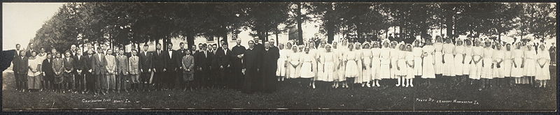
Today the only settlement left in Newton Township is Monti; traces of the old railroad grade can still be seen at the northern edge of the hamlet. St. Patrick's Catholic Church at Monti ceased regular masses in 2005.
Township (United States)
A township in the United States is a small geographic area. Townships range in size from 6 to 54 square miles , with being the norm.The term is used in three ways....
in Buchanan County
Buchanan County, Iowa
-2010 census:The 2010 census recorded a population of 20,958 in the county, with a population density of . There were 8,968 housing units, of which 8,161 were occupied.-2000 census:...
, Iowa
Iowa
Iowa is a state located in the Midwestern United States, an area often referred to as the "American Heartland". It derives its name from the Ioway people, one of the many American Indian tribes that occupied the state at the time of European exploration. Iowa was a part of the French colony of New...
, USA
United States
The United States of America is a federal constitutional republic comprising fifty states and a federal district...
. As of the 2000 census
United States Census, 2000
The Twenty-second United States Census, known as Census 2000 and conducted by the Census Bureau, determined the resident population of the United States on April 1, 2000, to be 281,421,906, an increase of 13.2% over the 248,709,873 persons enumerated during the 1990 Census...
, its population was 423.
Geography
Newton Township covers an area of 36.33 square miles (94.1 km²) and contains no incorporated settlements. The unincorporated community of MontiMonti, Iowa
Monti is a tiny unincorporated community located in the southeast corner of Buchanan County, Iowa, United States. Founded in the 1880s and platted in 1905, the community lies on the west bank of Buffalo Creek east of Quasqueton and west of Ryan....
is in the northern portion of the township. Other settlements in the township from the late 19th and early 20th centuries are abandoned. According to the USGS
United States Geological Survey
The United States Geological Survey is a scientific agency of the United States government. The scientists of the USGS study the landscape of the United States, its natural resources, and the natural hazards that threaten it. The organization has four major science disciplines, concerning biology,...
, Newton Township contains three cemeteries: Circle Grove, Saint Patrick's and Upper Spring Grove. Only Saint Patrick's of Monti is maintained.
History
The first permanent white settler in Newton Township was a Joseph Austin, who built a cabin "by a spring at the edge of some timber in the township" sometime before or during 1847. The first election was held in the southern part of the township in August 1854. Many early settlers of the area were from IrelandIreland
Ireland is an island to the northwest of continental Europe. It is the third-largest island in Europe and the twentieth-largest island on Earth...
.
Two cemeteries were established in the 1850s, one in the northern and one in the southern part of the township. A Catholic church and rectory
Rectory
A rectory is the residence, or former residence, of a rector, most often a Christian cleric, but in some cases an academic rector or other person with that title...
were constructed adjoining the northern cemetery in 1870. Newtonville was established in 1873, when a post office was built near the center of the township, at 42.347°N 91.675°W (Sections
Section (United States land surveying)
In U.S. land surveying under the Public Land Survey System , a section is an area nominally one square mile, containing , with 36 sections making up one survey township on a rectangular grid....
16 and 17, see map on right). In 1875, the State Atlas of Iowa showed two churches, seven schools, and 19 houses in the township. Just 11 years later, in 1886, Warner and Foote's map of Newton Township showed 137 houses, ten schools, three churches, and two post offices in the township.
Many other small settlements sprang up, including Erin, Atlantic, and Monti. None of these communities ever incorporated. Atlantic was located at 42.311°N 91.685°W (Sections 28 and 33), and Erin at 42.369°N 91.600°W (Section 1). Monti was founded in 1885, on Buffalo Creek in the northern part of the township, at the location of the Catholic church (Sections 2 and 3). With the introduction of Rural Free Delivery in 1902, both the Newtonville and Monti post offices closed.
In 1911, the village of Kiene was founded 1.5 miles west of Monti at 42.384°N 91.661°W (Section 4), the result of a planned railway through the area. Kiene was named after Henry Kiene or Peter Kiene, presidents of the proposed rail line, who planned a rail route west from Dubuque toward Independence in 1903. The Chicago, Anamosa and Northern (CAN) Railway was built through Newton Township in 1912 and passed through both Kiene and Monti. Monti soon became a small but bustling community, with stores, a blacksmith shop, a bank, and a flag station. The old Newtonville Congregational Church was moved to Kiene in June 1914, and a new church was built at Newtonville. Kiene was a village of 25 residents in 1914; the populations of Newtonville and Monti were too small to report.
The post-World War I years saw a decline in the area's population. The CAN railroad was sold for scrap during World War II. The Newtonville, Erin, and Atlantic areas emptied. By 1955, the only structure remaining at Kiene was the church. The official 1956 school district map for Buchanan County shows only the locations of Kiene and Monti; by this time, the other villages were gone. The Kiene Congregational Church closed in 1970, its congregation merged into the Church of Christ United in Winthrop.
The school at Monti closed in 1966, with the disbanding of the Monti Consolidated School District. The northern portions of the district went to East Buchanan Community School District, while the southern areas were ceded to North Linn Community School District.
Today the only settlement left in Newton Township is Monti; traces of the old railroad grade can still be seen at the northern edge of the hamlet. St. Patrick's Catholic Church at Monti ceased regular masses in 2005.
Parks and recreation
There are two wildlife areas in Newton Township. The Newton Township Wildlife Area, established in 1998, is a 158 acre (0.63940388 km²) park located three miles (5 km) southeast of Monti at the eastern edge of the township. Canoeing, fishing, and hunting are permitted at the park. Frogville Access, established in 1978, is a 116 acre (0.46943576 km²) park between Quasqueton and Troy Mills. It lies in the southwestern corner of the township.External links
- Photograph of Kiene, Iowa, early 20th century, Iowa Digital Library.
- US-Counties.com
- City-Data.com Comprehensive Statistical Data and more about Newton Township