Newmarket Road, Cambridge
Encyclopedia


Arterial road
An arterial road, or arterial thoroughfare, is a high-capacity urban road. The primary function of an arterial road is to deliver traffic from collector roads to freeways, and between urban centres at the highest level of service possible. As such, many arteries are limited-access roads, or feature...
in the east of Cambridge
Cambridge
The city of Cambridge is a university town and the administrative centre of the county of Cambridgeshire, England. It lies in East Anglia about north of London. Cambridge is at the heart of the high-technology centre known as Silicon Fen – a play on Silicon Valley and the fens surrounding the...
, England
England
England is a country that is part of the United Kingdom. It shares land borders with Scotland to the north and Wales to the west; the Irish Sea is to the north west, the Celtic Sea to the south west, with the North Sea to the east and the English Channel to the south separating it from continental...
. It is designated the A1134 at the western end, linked by a roundabout
Roundabout
A roundabout is the name for a road junction in which traffic moves in one direction around a central island. The word dates from the early 20th century. Roundabouts are common in many countries around the world...
forming a junction with Barnwell Road (A1134) to the south. The eastern end links with the city's inner ring road
Ring road
A ring road, orbital motorway, beltway, circumferential highway, or loop highway is a road that encircles a town or city...
at another roundabout, with Elizabeth Way
Elizabeth Way, Cambridge
Elizabeth Way is a road in northeast Cambridge, England. It is designated the A1134 and forms part of Cambridge's inner ring road. At the northern end is a roundabout forming a junction with Milton Road...
(A1134) to the north and East Road
East Road, Cambridge
East Road is a dual-carriageway road in the east of Cambridge, England. It is designated the A603 and forms part of Cambridge's inner ring road. The southwest end of East Road is next to Parker's Piece, at the junction with Parkside, Mill Road, and Gonville Place...
(A603) to the southeast. Newmarket Road continues a short way towards the city centre, becoming Maid's Causeway and then Jesus Lane
Jesus Lane
Jesus Lane is a historical street in central Cambridge, England. The street links with the junction of Bridge Street and Sidney Street to the west. To the east is a roundabout. To the south is King Street, running parallel with Jesus Lane and linking at the roundabout. The road continues east as...
. To the east, the road becomes the A1303
A1303 road
The A1303 is a predominantly single carriageway road running entirely in the county of Cambridgeshire, England. Prior to the construction of the Cambridge northern bypass and the Newmarket bypass, the A1303 had been classified as part of the A45....
and crosses the A14 at a major roundabout, continuing further east and parallel to the A14 out of the city. The road is named after the market town
Market town
Market town or market right is a legal term, originating in the medieval period, for a European settlement that has the right to host markets, distinguishing it from a village and city...
of Newmarket in Suffolk
Suffolk
Suffolk is a non-metropolitan county of historic origin in East Anglia, England. It has borders with Norfolk to the north, Cambridgeshire to the west and Essex to the south. The North Sea lies to the east...
, east of Cambridge.
The Abbey Stadium
Abbey Stadium
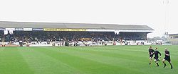
The Abbey Stadium, known as R Costings Abbey Stadium for sponsorship reasons, is a football stadium in Cambridge, England. It has been the home ground of Cambridge United F.C. since 1932, and currently has a maximum capacity of 9,617 spectators...
, home of Cambridge United Football Club
Cambridge United F.C.
Cambridge United Football Club is a professional football club from Cambridge, England. They are currently playing the 2011-2012 season in the Conference National, the fifth tier of the English league system, where they have competed since 2005 following their relegation from the Football League...
is to the south of the road. The section at the north end of the stadium next to the road is known as the Newmarket Road End. The historic Leper Chapel
Leper Chapel, Cambridge
The Leper Chapel in Cambridge, also currently known as the Leper Chapel of St. Mary Magdalene, lies on the east side of Cambridge, England, off Newmarket Road just after crossing over the railway line at Barnwell Junction...
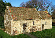
of St Mary Magdalene is also close to the road, where it crosses the railway. Dating from 1125, it is probably the oldest surviving building in Cambridge. The Cambridge City Cemetery
Cemetery
A cemetery is a place in which dead bodies and cremated remains are buried. The term "cemetery" implies that the land is specifically designated as a burying ground. Cemeteries in the Western world are where the final ceremonies of death are observed...
is off the road to the north. There is a brick-built cemetery chapel.
On the edge of the city south of Newmarket Road and west of the village of Teversham
Teversham
Teversham is a small village in Cambridgeshire located roughly from Fulbourn, and is roughly from the centre of Cambridge. It is a small village compared to neighbouring ones...
is Cambridge Airport
Cambridge Airport
Cambridge Airport is a small regional airport in South Cambridgeshire, England. It is located on the eastern outskirts of Cambridge, south of Newmarket Road and west of the village of Teversham, from the centre of Cambridge and approximately from London.Opened in 1938, when it replaced the old...
. The main building was designed by the architect Harold Tomlinson
Harold Tomlinson
Harold Tomlinson was a 20th century British architect.Tomlinson was based at the University of Cambridge School of Architecture. There he supervised the Scottish architect Frank James Connell....
and constructed 1936–37.
The road includes large out-of-town stores such as B&Q
B&Q
B&Q plc is a multinational DIY and home improvement retailer headquartered in Eastleigh, United Kingdom. It was founded in 1969 and is a wholly owned subsidiary of Kingfisher plc, which is listed on the London Stock Exchange....
, which forms part of more than 740000 square feet (68,748.2 m²) of retail space. There are also a number of car showrooms.

