

New York State Route 55A
Encyclopedia
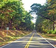
New York State Route 55A (NY 55A) is a state highway located in Sullivan
and Ulster counties. It is a loop route connected to NY 55
at both ends, near Grahamsville in the west and Napanoch
in the east. Inside the loop is New York City
's Rondout Reservoir
, which provides some beautiful scenery from both highways.
, going at first slightly northeast along the west end of the reservoir. In a mile it turns abruptly to the right once again as the roadway it follows continues as a county road to Sundown
.
 It crosses the mouth of Rondout Creek
on a long bridge over swampy areas where the creek reaches the reservoir. Afterwards it goes into much more wooded land.
It remains close to the reservoir's north shore for the rest of its route, offering many glimpses of the reservoir and access to it for those who have boating
or fishing
permits (Otherwise, access is severely restricted). At the east end of the reservoir, the view to Merriman Dam is better from NY 55A than from NY 55.
Not long afterward, NY 55A ends at NY 55 once again in the town of Wawarsing
, several miles northwest of the community of Napanoch
.
 When NY 55
was assigned as part of the 1930 renumbering of state highways in New York, it was routed along the northern bank of Rondout Creek
between the hamlets of Grahamsville
and Lackawack. In the mid-1940s, NY 55 was realigned to follow a new highway along the southern bank while its former routing to the north became NY 55A. The westernmost portion of the northern route was also reconfigured by this time to cross Rondout Creek at Lowes Corners. Both changes were made in order to accommodate the Rondout Reservoir
, which was created ca. 1950 following the construction of the Merriman Dam. The reservoir was completely contained within the NY 55 / NY 55A loop, with NY 55 forming the southern edge and NY 55A comprising the western and northern extents.
Sullivan County, New York
Sullivan County is a county located in the U.S. state of New York. As of the 2010 census, the population was 77,547. The county seat is Monticello. The name is in honor of Major General John Sullivan, who was a hero in the American Revolutionary War...
and Ulster counties. It is a loop route connected to NY 55
New York State Route 55
New York State Route 55 is a state highway in southern New York, running from the Pennsylvania state line at the Delaware River in Barryville to the Connecticut state line at Wingdale...
at both ends, near Grahamsville in the west and Napanoch
Napanoch, New York
Napanoch is a hamlet in Ulster County, New York. It is at the junction of routes 209 and 55. It is on the Shawangunk Ridge National Scenic Byway, and is part of the Hudson River Valley National Heritage Area....
in the east. Inside the loop is New York City
New York City
New York is the most populous city in the United States and the center of the New York Metropolitan Area, one of the most populous metropolitan areas in the world. New York exerts a significant impact upon global commerce, finance, media, art, fashion, research, technology, education, and...
's Rondout Reservoir
Rondout Reservoir
Rondout Reservoir is part of New York City's water supply network. It is located 75 miles northwest of the city in the Catskill Mountains, near the southern end of Catskill Park, split between the towns of Wawarsing in Ulster County and Neversink in Sullivan County...
, which provides some beautiful scenery from both highways.
Route description
NY 55A leaves NY 55 just east of GrahamsvilleGrahamsville, New York
Grahamsville is an unincorporated hamlet at the junction of NY 42 and 55 in the Town of Neversink, in Sullivan County, New York, USA. It is near the western end of Rondout Reservoir, and is the southernmost community in the Catskill Park...
, going at first slightly northeast along the west end of the reservoir. In a mile it turns abruptly to the right once again as the roadway it follows continues as a county road to Sundown
Sundown, New York
Sundown is a hamlet located within Denning, New York, in Ulster County, New York, United States. It is 34.6 miles from the city of Kingston, New York and 119 miles from New York City. Sundown is near the south town line of Denning on Route 46....
.
Rondout Creek
Rondout Creek is a tributary of the Hudson River in Ulster and Sullivan counties, New York, USA. It rises on Rocky Mountain in the eastern Catskills, flows south into Rondout Reservoir, part of New York City's water supply network, then into the valley between the Catskills and the Shawangunk...
on a long bridge over swampy areas where the creek reaches the reservoir. Afterwards it goes into much more wooded land.
It remains close to the reservoir's north shore for the rest of its route, offering many glimpses of the reservoir and access to it for those who have boating
Boating
Boating is the leisurely activity of travelling by boat, or the recreational use of a boat whether powerboats, sailboats, or man-powered vessels , focused on the travel itself, as well as sports activities, such as fishing or water skiing...
or fishing
Angling
Angling is a method of fishing by means of an "angle" . The hook is usually attached to a fishing line and the line is often attached to a fishing rod. Fishing rods are usually fitted with a fishing reel that functions as a mechanism for storing, retrieving and paying out the line. The hook itself...
permits (Otherwise, access is severely restricted). At the east end of the reservoir, the view to Merriman Dam is better from NY 55A than from NY 55.
Not long afterward, NY 55A ends at NY 55 once again in the town of Wawarsing
Wawarsing, New York
Wawarsing is a town in Ulster County, New York, United States. The population was 13,157 at the 2010 census. The name means "a place where the stream bends" in the Warwarsink language and refers to the geography of the land; particularly the joining of the Ver Nooy Kill and the Rondout Creek. The...
, several miles northwest of the community of Napanoch
Napanoch, New York
Napanoch is a hamlet in Ulster County, New York. It is at the junction of routes 209 and 55. It is on the Shawangunk Ridge National Scenic Byway, and is part of the Hudson River Valley National Heritage Area....
.
History
New York State Route 55
New York State Route 55 is a state highway in southern New York, running from the Pennsylvania state line at the Delaware River in Barryville to the Connecticut state line at Wingdale...
was assigned as part of the 1930 renumbering of state highways in New York, it was routed along the northern bank of Rondout Creek
Rondout Creek
Rondout Creek is a tributary of the Hudson River in Ulster and Sullivan counties, New York, USA. It rises on Rocky Mountain in the eastern Catskills, flows south into Rondout Reservoir, part of New York City's water supply network, then into the valley between the Catskills and the Shawangunk...
between the hamlets of Grahamsville
Grahamsville, New York
Grahamsville is an unincorporated hamlet at the junction of NY 42 and 55 in the Town of Neversink, in Sullivan County, New York, USA. It is near the western end of Rondout Reservoir, and is the southernmost community in the Catskill Park...
and Lackawack. In the mid-1940s, NY 55 was realigned to follow a new highway along the southern bank while its former routing to the north became NY 55A. The westernmost portion of the northern route was also reconfigured by this time to cross Rondout Creek at Lowes Corners. Both changes were made in order to accommodate the Rondout Reservoir
Rondout Reservoir
Rondout Reservoir is part of New York City's water supply network. It is located 75 miles northwest of the city in the Catskill Mountains, near the southern end of Catskill Park, split between the towns of Wawarsing in Ulster County and Neversink in Sullivan County...
, which was created ca. 1950 following the construction of the Merriman Dam. The reservoir was completely contained within the NY 55 / NY 55A loop, with NY 55 forming the southern edge and NY 55A comprising the western and northern extents.