
New York State Route 267
Encyclopedia
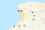
New York State Route 267 (NY 267) was an east–west state highway
in the western portion
of New York
in the United States. It extended for 7.16 miles (11.52 km) from an intersection with NY 93
in the Erie County
village of Akron
to a junction with NY 77
in the Genesee County
hamlet of Basom. Part of NY 267 in Genesee County passed through the Tonawanda Indian Reservation. The portion of NY 267 within Erie County was assigned ca. 1935. NY 267 was extended east to NY 77 in Basom in the late 1930s, replacing New York State Route 77A, a spur leading from NY 77 to the eastern edge of the Tonawanda Reservation. The Erie County segment of the route was transferred from the state of New York
to Erie County in April 1980, leading to the total removal of the NY 267 designation in August of that year.
 NY 267 began at an intersection with NY 93
in the village of Akron
in eastern Erie County
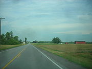
. The route headed eastward, following John Street through downtown Akron. NY 267 broke from John Street just four blocks later. While the street continued east to serve Akron Airport
, the route turned northeast to follow Bloomingdale Road out of the village. The route continued through gradually less developed areas of the town of Newstead
, intersecting with County Route 250 (CR 250, named Scotland Road). NY 267 crossed into Genesee County
soon afterward.
In the Genesee County town of Alabama
, NY 267 made a slight turn to the north as it entered the Tonawanda Indian Reservation. Once inside the reservation, the route remained on a north-northeasterly alignment for about 0.5 mile (0.80467 km) to a junction with Parker Road. At this point, the highway turned to the east, progressing across the reservation. At an intersection with Reuben Road 1.25 miles (2.01 km) later, NY 267 turned to the north for another 0.5 mile (0.80467 km) before it exited the reservation. The route continued for roughly 1 miles (1.6 km) to the hamlet of Basom, where it terminated at an intersection with NY 77
.
 NY 267 was assigned ca. 1935 to a routing extending from NY 93
in Akron
to the Erie
–Genesee
county line by way of John Street and Bloomingdale Road. Farther east, the portion of Bloomingdale Road between the Tonawanda Indian Reservation and NY 77
was designated as NY 77A around the same time. NY 77A and the remainder of Bloomingdale Road within Genesee County became an extension of NY 267 in the late 1930s. On April 1, 1980, ownership and maintenance of the portion of NY 267 within Erie County—by this point the lone state-maintained portion of the route—was transferred from the state of New York
to Erie County as part of a highway maintenance swap between the two levels of government. The NY 267 designation was removed from the entirety of its routing just over four months later on August 14, 1980. The Erie County segment of the route is now CR 573 while the Genesee County section is locally maintained.
State highway
State highway, state road or state route can refer to one of three related concepts, two of them related to a state or provincial government in a country that is divided into states or provinces :#A...
in the western portion
Western New York
Western New York is the westernmost region of the state of New York. It includes the cities of Buffalo, Rochester, Niagara Falls, the surrounding suburbs, as well as the outlying rural areas of the Great Lakes lowlands, the Genesee Valley, and the Southern Tier. Some historians, scholars and others...
of New York
New York
New York is a state in the Northeastern region of the United States. It is the nation's third most populous state. New York is bordered by New Jersey and Pennsylvania to the south, and by Connecticut, Massachusetts and Vermont to the east...
in the United States. It extended for 7.16 miles (11.52 km) from an intersection with NY 93
New York State Route 93
New York State Route 93 is a state highway in western New York in the United States. It runs in a northwest–southeast direction between NY 18F near the Niagara River in the village of Youngstown and NY 5 just south of the village of Akron...
in the Erie County
Erie County, New York
Erie County is a county located in the U.S. state of New York. As of the 2010 census, the population was 919,040. The county seat is Buffalo. The county's name comes from Lake Erie, which in turn comes from the Erie tribe of American Indians who lived south and east of the lake before 1654.Erie...
village of Akron
Akron, New York
Akron, New York is a village in Erie County, New York, United States. The population was listed as 3,085 in the 2000 census. The name means a high place. It is part of the Buffalo–Niagara Falls Metropolitan Statistical Area....
to a junction with NY 77
New York State Route 77
New York State Route 77 is a north–south state highway in the western part of New York in the United States. The highway runs for across mostly rural areas from an intersection with NY 78 and NY 98 in the Wyoming County town of Java to a junction with NY 31 near the city of...
in the Genesee County
Genesee County, New York
Genesee County is a county located in Western New York, United States. As of the 2010 census, the population was 60,079. Its name is from the Seneca Indian word Gen-nis'-hee-yo meaning "The Beautiful Valley." Its county seat is Batavia.- History :...
hamlet of Basom. Part of NY 267 in Genesee County passed through the Tonawanda Indian Reservation. The portion of NY 267 within Erie County was assigned ca. 1935. NY 267 was extended east to NY 77 in Basom in the late 1930s, replacing New York State Route 77A, a spur leading from NY 77 to the eastern edge of the Tonawanda Reservation. The Erie County segment of the route was transferred from the state of New York
New York
New York is a state in the Northeastern region of the United States. It is the nation's third most populous state. New York is bordered by New Jersey and Pennsylvania to the south, and by Connecticut, Massachusetts and Vermont to the east...
to Erie County in April 1980, leading to the total removal of the NY 267 designation in August of that year.
Route description
New York State Route 93
New York State Route 93 is a state highway in western New York in the United States. It runs in a northwest–southeast direction between NY 18F near the Niagara River in the village of Youngstown and NY 5 just south of the village of Akron...
in the village of Akron
Akron, New York
Akron, New York is a village in Erie County, New York, United States. The population was listed as 3,085 in the 2000 census. The name means a high place. It is part of the Buffalo–Niagara Falls Metropolitan Statistical Area....
in eastern Erie County
Erie County, New York
Erie County is a county located in the U.S. state of New York. As of the 2010 census, the population was 919,040. The county seat is Buffalo. The county's name comes from Lake Erie, which in turn comes from the Erie tribe of American Indians who lived south and east of the lake before 1654.Erie...
. The route headed eastward, following John Street through downtown Akron. NY 267 broke from John Street just four blocks later. While the street continued east to serve Akron Airport
Akron Airport
Akron Airport is a privately owned, public-use airport located one nautical miles east of the central business district of Akron, a village in Erie County, New York, United States.- Facilities and aircraft :...
, the route turned northeast to follow Bloomingdale Road out of the village. The route continued through gradually less developed areas of the town of Newstead
Newstead, New York
Newstead is the most northeastern town in Erie County, New York, United States. The population was 8,404 at the 2000 census. The name is reportedly derived from Newstead Abbey in England....
, intersecting with County Route 250 (CR 250, named Scotland Road). NY 267 crossed into Genesee County
Genesee County, New York
Genesee County is a county located in Western New York, United States. As of the 2010 census, the population was 60,079. Its name is from the Seneca Indian word Gen-nis'-hee-yo meaning "The Beautiful Valley." Its county seat is Batavia.- History :...
soon afterward.
In the Genesee County town of Alabama
Alabama, New York
Alabama is a town in Genesee County, New York, United States. The town is in the northwest part of the county. New York State Route 63 and New York State Route 77 intersect in the town. The population was 1,881 at the 2000 census...
, NY 267 made a slight turn to the north as it entered the Tonawanda Indian Reservation. Once inside the reservation, the route remained on a north-northeasterly alignment for about 0.5 mile (0.80467 km) to a junction with Parker Road. At this point, the highway turned to the east, progressing across the reservation. At an intersection with Reuben Road 1.25 miles (2.01 km) later, NY 267 turned to the north for another 0.5 mile (0.80467 km) before it exited the reservation. The route continued for roughly 1 miles (1.6 km) to the hamlet of Basom, where it terminated at an intersection with NY 77
New York State Route 77
New York State Route 77 is a north–south state highway in the western part of New York in the United States. The highway runs for across mostly rural areas from an intersection with NY 78 and NY 98 in the Wyoming County town of Java to a junction with NY 31 near the city of...
.
History
New York State Route 93
New York State Route 93 is a state highway in western New York in the United States. It runs in a northwest–southeast direction between NY 18F near the Niagara River in the village of Youngstown and NY 5 just south of the village of Akron...
in Akron
Akron, New York
Akron, New York is a village in Erie County, New York, United States. The population was listed as 3,085 in the 2000 census. The name means a high place. It is part of the Buffalo–Niagara Falls Metropolitan Statistical Area....
to the Erie
Erie County, New York
Erie County is a county located in the U.S. state of New York. As of the 2010 census, the population was 919,040. The county seat is Buffalo. The county's name comes from Lake Erie, which in turn comes from the Erie tribe of American Indians who lived south and east of the lake before 1654.Erie...
–Genesee
Genesee County, New York
Genesee County is a county located in Western New York, United States. As of the 2010 census, the population was 60,079. Its name is from the Seneca Indian word Gen-nis'-hee-yo meaning "The Beautiful Valley." Its county seat is Batavia.- History :...
county line by way of John Street and Bloomingdale Road. Farther east, the portion of Bloomingdale Road between the Tonawanda Indian Reservation and NY 77
New York State Route 77
New York State Route 77 is a north–south state highway in the western part of New York in the United States. The highway runs for across mostly rural areas from an intersection with NY 78 and NY 98 in the Wyoming County town of Java to a junction with NY 31 near the city of...
was designated as NY 77A around the same time. NY 77A and the remainder of Bloomingdale Road within Genesee County became an extension of NY 267 in the late 1930s. On April 1, 1980, ownership and maintenance of the portion of NY 267 within Erie County—by this point the lone state-maintained portion of the route—was transferred from the state of New York
New York
New York is a state in the Northeastern region of the United States. It is the nation's third most populous state. New York is bordered by New Jersey and Pennsylvania to the south, and by Connecticut, Massachusetts and Vermont to the east...
to Erie County as part of a highway maintenance swap between the two levels of government. The NY 267 designation was removed from the entirety of its routing just over four months later on August 14, 1980. The Erie County segment of the route is now CR 573 while the Genesee County section is locally maintained.