

New York State Route 213
Encyclopedia
New York State Route 213 (NY 213) is a state highway located entirely in Ulster County
. It runs from the eastern Catskills
to downtown Kingston
.
While it is signed as an east–west route, most of its course consists of two segments running in a more north–south direction, giving it a V-shape on the map. The only section of the highway to truly run east–west is a middle segment between its two concurrencies
, in the vicinity of High Falls
.
along the south side of Ashokan Reservoir
, not far from the now-closed spillway
road. It shortly winds its way down through Olivebridge
, across the Blue Line
and out of the Catskill Park, following a more southeasterly tack. When approaching from the east, a spectacular view of Ashokan High Point
is available from this section.
 Much of this section feels more like the county roads it overlaps, winding through narrow, wooded stretches and rounding some 90-degree angled corners, situations not normally found on state highways. Only just before downtown Stone Ridge
does the road begin to open up and straighten out.
. A half-mile south of the hamlet, it leaves to the east at a traffic light
. After that, it heads more directly to the east, crossing Rondout Creek
just above the falls that give High Falls
its name.
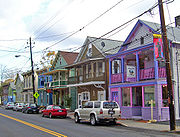 It passes through downtown High Falls
with its shops, trendy restaurants and remnants of the Delaware and Hudson Canal
, then heads east into the Town of Marbletown
. It follows the creek again and begins to curve northward.
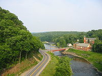 In Rosendale
213 meets NY 32
and crosses the creek with it. The concurrency ends at the next major water crossing, the Wallkill River
, just past Tillson
. After that bridge, it turns to the northeast again and follows the river under the New York State Thruway
past the parklike areas around Sturgeon Pool
in Rifton
, formed by the Wallkill's impoundment
near its mouth.
After the pond ends, 213 runs parallel to the Rondout (although some distance away), along a straighter course toward another crossing at New Salem, just outside of the city limits of Kingston
. Once in Kingston, it follows Abeel Street, turning left at Wilbur Avenue. After a lengthy winding route, it turns right on Greenkill Avenue for one block, then left on Clinton Avenue. Two blocks later, it meets NY 32 at Henry Street, turning right and overlapping it for four blocks until it reaches Broadway. NY 32 continues left, and NY 213 ends.
at the west end of the Ashokan Reservoir
in Boiceville
and followed what is now NY 28A
southeastward around the reservoir to Olivebridge
. Here, it turned onto its modern alignment and proceeded eastward to Rosendale
, initially the junction of NY 213 and NY 376, a north–south connector between Rosendale and Dashville. The route continued northeast from Rosendale on modern NY 32
to Kingston, where it ended in the western portion of the city. At the time, the segment of modern NY 213 between Dashville and Kingston was part of NY 32. Ca. 1933, NY 213 was truncated to its current western terminus in Olivebridge and rerouted east of Rosendale to follow NY 376 and NY 32 to Kingston. The former alignment of NY 213 north of Rosendale became part of a realigned NY 32.
Ulster County, New York
Ulster County is a county located in the state of New York, USA. It sits in the state's Mid-Hudson Region of the Hudson Valley. As of the 2010 census, the population was 182,493. Recent population estimates completed by the United States Census Bureau for the 12-month period ending July 1 are at...
. It runs from the eastern Catskills
Catskill Mountains
The Catskill Mountains, an area in New York State northwest of New York City and southwest of Albany, are a mature dissected plateau, an uplifted region that was subsequently eroded into sharp relief. They are an eastward continuation, and the highest representation, of the Allegheny Plateau...
to downtown Kingston
Kingston, New York
Kingston is a city in and the county seat of Ulster County, New York, USA. It is north of New York City and south of Albany. It became New York's first capital in 1777, and was burned by the British Oct. 16, 1777, after the Battles of Saratoga...
.
While it is signed as an east–west route, most of its course consists of two segments running in a more north–south direction, giving it a V-shape on the map. The only section of the highway to truly run east–west is a middle segment between its two concurrencies
Concurrency (road)
A concurrency, overlap, or coincidence in a road network is an instance of one physical road bearing two or more different highway, motorway, or other route numbers...
, in the vicinity of High Falls
High Falls, New York
High Falls is a hamlet in Ulster County, New York, United States. The population was 627 at the 2000 census.High Falls is located in Marbletown, near the town boundary with Rosendale.-Geography:...
.
Olivebridge to Stone Ridge
Route 213 begins in the east at a junction with NY 28ANew York State Route 28A
New York State Route 28A is an east–west state highway in Ulster County, New York, in the United States. It extends for along the south side of Ashokan Reservoir in Catskill Park, serving as a southerly alternate route of NY 28 through the area...
along the south side of Ashokan Reservoir
Ashokan Reservoir
The Ashokan Reservoir is a reservoir in Ulster County, New York, USA. The reservoir is in the eastern end of the Catskill Park, and is one of several reservoirs created to provide the City of New York with water. However, it is one of only two reservoirs in the Catskill Watershed. It is also New...
, not far from the now-closed spillway
Spillway
A spillway is a structure used to provide the controlled release of flows from a dam or levee into a downstream area, typically being the river that was dammed. In the UK they may be known as overflow channels. Spillways release floods so that the water does not overtop and damage or even destroy...
road. It shortly winds its way down through Olivebridge
Olivebridge, New York
Olivebridge is a hamlet in Ulster County, New York, United States, within Catskill Park and the Catskill Mountains.The community's name is sometimes written Olive Bridge, but the United States Board on Geographic Names gives the name as Olivebridge...
, across the Blue Line
Blue Line (New York State)
The Blue Line is the term used in New York state for the boundaries of the Adirondack and Catskill parks, within which can be found the state's Forest Preserve...
and out of the Catskill Park, following a more southeasterly tack. When approaching from the east, a spectacular view of Ashokan High Point
Ashokan High Point
Ashokan High Point is a summit in the Catskill Mountains of New York. The trail that leads up to it is very old....
is available from this section.
Stone Ridge, New York
Stone Ridge is a hamlet in Ulster County, New York, United States. The population was 1,173 at the 2000 census.Stone Ridge is located in the Town of Marbletown, along US 209 where it overlaps NY 213.-Geography:...
does the road begin to open up and straighten out.
Stone Ridge to High Falls
In Stone Ridge 213 joins US 209 for a mile or so, along the hamlet's historic Main StreetMain Street Historic District (Stone Ridge, New York)
The Main Street Historic District in Stone Ridge, New York, United States, is located along US 209/NY 213 in that hamlet, part of the Town of Marbletown in Ulster County. It is a strip from the southern end of the unincorporated community to a short distance north of the intersection at Cooper...
. A half-mile south of the hamlet, it leaves to the east at a traffic light
Traffic light
Traffic lights, which may also be known as stoplights, traffic lamps, traffic signals, signal lights, robots or semaphore, are signalling devices positioned at road intersections, pedestrian crossings and other locations to control competing flows of traffic...
. After that, it heads more directly to the east, crossing Rondout Creek
Rondout Creek
Rondout Creek is a tributary of the Hudson River in Ulster and Sullivan counties, New York, USA. It rises on Rocky Mountain in the eastern Catskills, flows south into Rondout Reservoir, part of New York City's water supply network, then into the valley between the Catskills and the Shawangunk...
just above the falls that give High Falls
High Falls, New York
High Falls is a hamlet in Ulster County, New York, United States. The population was 627 at the 2000 census.High Falls is located in Marbletown, near the town boundary with Rosendale.-Geography:...
its name.
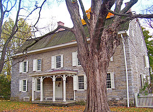
High Falls Historic District
The High Falls Historic District corresponds roughly to the downtown section of the hamlet of that name in Marbletown, New York, United States. It is a area around the intersection of state highway NY 213, Main Street, Mohonk Road The High Falls Historic District corresponds roughly to the...
with its shops, trendy restaurants and remnants of the Delaware and Hudson Canal
Delaware and Hudson Canal
The Delaware and Hudson Canal was the first venture of the Delaware and Hudson Canal Company, which later developed the Delaware and Hudson Railway...
, then heads east into the Town of Marbletown
Marbletown, New York
Marbletown is a town in Ulster County, New York, United States. The population was 5,854 at the 2000 census.The Town of Marbletown is near the center of Ulster County, southwest of the City of Kingston. US 209 and NY 213 pass through the town...
. It follows the creek again and begins to curve northward.
Rosendale to Kingston
Rosendale, New York
Rosendale is a town in the center of Ulster County, New York, United States. It once contained a village of the same name, which was dissolved through a vote. The population was 6,075 at the 2010 census.- History :...
213 meets NY 32
New York State Route 32
New York State Route 32 is a north–south state highway that extends for through the Hudson Valley and Capital District regions of the U.S. state of New York. It is a two-lane surface road for nearly its entire length, with few divided and no limited-access sections. From Harriman to Albany,...
and crosses the creek with it. The concurrency ends at the next major water crossing, the Wallkill River
Wallkill River
The Wallkill River, a tributary of the Hudson, drains Lake Mohawk in Sparta, New Jersey, flowing from there generally northeasterly to Rondout Creek in New York, near Rosendale, with the combined flows reaching the Hudson at Kingston....
, just past Tillson
Tillson, New York
Tillson is a hamlet in Ulster County, New York, United States. The population was 1,709 at the 2000 census.Tillson is in the Town of Rosendale, along routes 32 and 213.-Geography:Tillson is located at ....
. After that bridge, it turns to the northeast again and follows the river under the New York State Thruway
New York State Thruway
The New York State Thruway is a system of limited-access highways located within the state of New York in the United States. The system, known officially as the Governor Thomas E. Dewey Thruway for former New York Governor Thomas E. Dewey, is operated by the New York State Thruway Authority and...
past the parklike areas around Sturgeon Pool
Sturgeon Pool
Sturgeon Pool is a reservoir near the hamlet of Rifton, in the Town of Esopus in Ulster County, New York.It was created by damming the Wallkill River just above its confluence with Rondout Creek for hydroelectricity ....
in Rifton
Rifton, New York
Rifton is a hamlet in Ulster County, New York, United States. The population was 501 at the 2000 census.Rifton is near the west town line of the Town of Esopus on Route 213.-History:...
, formed by the Wallkill's impoundment
Dam
A dam is a barrier that impounds water or underground streams. Dams generally serve the primary purpose of retaining water, while other structures such as floodgates or levees are used to manage or prevent water flow into specific land regions. Hydropower and pumped-storage hydroelectricity are...
near its mouth.
After the pond ends, 213 runs parallel to the Rondout (although some distance away), along a straighter course toward another crossing at New Salem, just outside of the city limits of Kingston
Kingston, New York
Kingston is a city in and the county seat of Ulster County, New York, USA. It is north of New York City and south of Albany. It became New York's first capital in 1777, and was burned by the British Oct. 16, 1777, after the Battles of Saratoga...
. Once in Kingston, it follows Abeel Street, turning left at Wilbur Avenue. After a lengthy winding route, it turns right on Greenkill Avenue for one block, then left on Clinton Avenue. Two blocks later, it meets NY 32 at Henry Street, turning right and overlapping it for four blocks until it reaches Broadway. NY 32 continues left, and NY 213 ends.
History
NY 213 was assigned as part of the 1930 renumbering of state highways in New York. Originally, NY 213 began at NY 28New York State Route 28
New York State Route 28 is a state highway extending for in the shape of a "C" between the Hudson Valley city of Kingston and southern Warren County in the U.S. state of New York. Along the way, it intersects several major routes, including Interstate 88 , U.S. Route 20 , and the...
at the west end of the Ashokan Reservoir
Ashokan Reservoir
The Ashokan Reservoir is a reservoir in Ulster County, New York, USA. The reservoir is in the eastern end of the Catskill Park, and is one of several reservoirs created to provide the City of New York with water. However, it is one of only two reservoirs in the Catskill Watershed. It is also New...
in Boiceville
Boiceville, New York
Boiceville is a community in Ulster County, New York, USA. Boiceville is located at the intersection with New York State Route 28 and New York State Route 28A, within Catskill State Park. The community is located at .-Education:...
and followed what is now NY 28A
New York State Route 28A
New York State Route 28A is an east–west state highway in Ulster County, New York, in the United States. It extends for along the south side of Ashokan Reservoir in Catskill Park, serving as a southerly alternate route of NY 28 through the area...
southeastward around the reservoir to Olivebridge
Olivebridge, New York
Olivebridge is a hamlet in Ulster County, New York, United States, within Catskill Park and the Catskill Mountains.The community's name is sometimes written Olive Bridge, but the United States Board on Geographic Names gives the name as Olivebridge...
. Here, it turned onto its modern alignment and proceeded eastward to Rosendale
Rosendale, New York
Rosendale is a town in the center of Ulster County, New York, United States. It once contained a village of the same name, which was dissolved through a vote. The population was 6,075 at the 2010 census.- History :...
, initially the junction of NY 213 and NY 376, a north–south connector between Rosendale and Dashville. The route continued northeast from Rosendale on modern NY 32
New York State Route 32
New York State Route 32 is a north–south state highway that extends for through the Hudson Valley and Capital District regions of the U.S. state of New York. It is a two-lane surface road for nearly its entire length, with few divided and no limited-access sections. From Harriman to Albany,...
to Kingston, where it ended in the western portion of the city. At the time, the segment of modern NY 213 between Dashville and Kingston was part of NY 32. Ca. 1933, NY 213 was truncated to its current western terminus in Olivebridge and rerouted east of Rosendale to follow NY 376 and NY 32 to Kingston. The former alignment of NY 213 north of Rosendale became part of a realigned NY 32.