

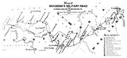
Nemacolin's Path
Encyclopedia
Indigenous peoples of the Americas
The indigenous peoples of the Americas are the pre-Columbian inhabitants of North and South America, their descendants and other ethnic groups who are identified with those peoples. Indigenous peoples are known in Canada as Aboriginal peoples, and in the United States as Native Americans...
trail that crossed the great barrier of the Allegheny Mountains
Allegheny Mountains
The Allegheny Mountain Range , also spelled Alleghany, Allegany and, informally, the Alleghenies, is part of the vast Appalachian Mountain Range of the eastern United States and Canada...
via the Cumberland Narrows
Cumberland Narrows
The Cumberland Narrows is a water gap in western Maryland in the United States, just west of Cumberland, Maryland. Wills Creek cuts through the central ridge of the Wills Mountain Anticline at a low elevation here between Wills Mountain to the north and Haystack Mountain to the south...
Mountain pass
Mountain pass
A mountain pass is a route through a mountain range or over a ridge. If following the lowest possible route, a pass is locally the highest point on that route...
and connected the Potomac River
Potomac River
The Potomac River flows into the Chesapeake Bay, located along the mid-Atlantic coast of the United States. The river is approximately long, with a drainage area of about 14,700 square miles...
and the Monongahela River
Monongahela River
The Monongahela River is a river on the Allegheny Plateau in north-central West Virginia and southwestern Pennsylvania in the United States...
watersheds on either side of the Allegheny range of the present-day USA. Nemacolin's Trail connected Cumberland, Maryland
Cumberland, Maryland
Cumberland is a city in the far western, Appalachian portion of Maryland, United States. It is the county seat of Allegany County, and the primary city of the Cumberland, MD-WV Metropolitan Statistical Area. At the 2010 census, the city had a population of 20,859, and the metropolitan area had a...
with what became Brownsville, Pennsylvania
Brownsville, Pennsylvania
Brownsville is a borough in Fayette County, Pennsylvania, United States, officially founded in 1785 located 35 miles south of Pittsburgh along the Monongahela River...
.
It was an ancient American Indian trail. When settlers improved it around 1750, it became the template trail, in large part the route for what became known on the eastern slopes as the eastern part of Braddock's Road. This was later improved as the Cumberland Road, the National Road
National Road
The National Road or Cumberland Road was the first major improved highway in the United States to be built by the federal government. Construction began heading west in 1811 at Cumberland, Maryland, on the Potomac River. It crossed the Allegheny Mountains and southwestern Pennsylvania, reaching...
, the National Pike, and eventually U.S. Route 40
U.S. Route 40
U.S. Route 40 is an east–west United States highway. As with most routes whose numbers end in a zero, U.S. 40 once traversed the entire United States. It is one of the original 1920s U.S. Highways, and its first termini were San Francisco, California, and Atlantic City, New Jersey...
, the so-called National Highway. U.S. Route 40
U.S. Route 40
U.S. Route 40 is an east–west United States highway. As with most routes whose numbers end in a zero, U.S. 40 once traversed the entire United States. It is one of the original 1920s U.S. Highways, and its first termini were San Francisco, California, and Atlantic City, New Jersey...
became one of the first officially recognized highways in the United States. The earlier road, known as the Cumberland Road/National Road, ran on the first cast iron bridge
Dunlap's Creek Bridge
Dunlap's Creek Bridge was the first cast iron, metal arch bridge in the United States. It was designed by Richard Delafield and built by the United States Army Corps of Engineers. Constructed from 1836 to 1839 on the National Road in Brownsville, Pennsylvania, it remains in use today...
constructed in the United States, at Dunlap's Creek. Nemacolin's Trail became the gateway by which settlers in Conestoga wagons or by stage coaches reached the promised lands of the American near and far west.
Crossing the Allegheny divide was a major task, requiring much planning, time and effort, until well into the 20th century as evidenced by the lack of east-west highways for the length of the border between Virginia
Virginia
The Commonwealth of Virginia , is a U.S. state on the Atlantic Coast of the Southern United States. Virginia is nicknamed the "Old Dominion" and sometimes the "Mother of Presidents" after the eight U.S. presidents born there...
and West Virginia
West Virginia
West Virginia is a state in the Appalachian and Southeastern regions of the United States, bordered by Virginia to the southeast, Kentucky to the southwest, Ohio to the northwest, Pennsylvania to the northeast and Maryland to the east...
the two regions sundered by some of the harshest terrain in the mountain chain. Crossing the Allegheny range to the north of the Cumberland Gap or to the south is feasible only hundreds of miles to either the north or south. The ridgelines are oriented north-south, presenting a virtually impassible obstacle to east-west travel.
Nemacolin's Path starts from a site in present day Cumberland, Maryland
Cumberland, Maryland
Cumberland is a city in the far western, Appalachian portion of Maryland, United States. It is the county seat of Allegany County, and the primary city of the Cumberland, MD-WV Metropolitan Statistical Area. At the 2010 census, the city had a population of 20,859, and the metropolitan area had a...
, continuing on to Brownsville, Pennsylvania
Brownsville, Pennsylvania
Brownsville is a borough in Fayette County, Pennsylvania, United States, officially founded in 1785 located 35 miles south of Pittsburgh along the Monongahela River...
to the neighborhood known today as Redstone located at mouth of Redstone Creek
Redstone Creek
Redstone Creek is a historically important widemouthed canoe and river boat-navigable brook-sized tributary stream of the Monongahela River in Fayette County, Pennsylvania. The creek is long, running from headwaters on Chestnut Ridge north through the city of Uniontown and reaching the Monongahela...
. In colonial America, the site was known as Redstone Old Fort
Redstone Old Fort
Redstone Old Fort or Redstone Fort or Fort Burd on The Nemacolin Trail was the name of the French and Indian War era wooden fort built in 1759 by Pennsylvania Militia Colonel James Burd to guard the ancient Indian trail's river ford on a mound overlooking the eastern shore of the Monongahela River...
for its defensive installation. During 1749 and 1750, the Delaware
Delaware
Delaware is a U.S. state located on the Atlantic Coast in the Mid-Atlantic region of the United States. It is bordered to the south and west by Maryland, and to the north by Pennsylvania...
Indian chief Nemacolin and Maryland
Maryland
Maryland is a U.S. state located in the Mid Atlantic region of the United States, bordering Virginia, West Virginia, and the District of Columbia to its south and west; Pennsylvania to its north; and Delaware to its east...
frontiersman Thomas Cresap
Thomas Cresap
Colonel Thomas Cresap was an English-born pioneer settler in the state of Maryland, and an agent of Lord Baltimore in the Maryland-Pennsylvania boundary dispute. During the dispute, Cresap became a notorious figure in the Conejohela Flats areathe Susquehanna Valley in the area south of Wright's...
supervised improving the trail.
Later, during the French and Indian War
French and Indian War
The French and Indian War is the common American name for the war between Great Britain and France in North America from 1754 to 1763. In 1756, the war erupted into the world-wide conflict known as the Seven Years' War and thus came to be regarded as the North American theater of that war...
, the eastern part of Nemacolin's Path was used as military route for British General Edward Braddock's ill-fated attempt to capture Fort Duquesne
Fort Duquesne
Fort Duquesne was a fort established by the French in 1754, at the junction of the Allegheny and Monongahela rivers in what is now downtown Pittsburgh in the state of Pennsylvania....
. It was forestalled by the capture of the force under Colonel
Colonel
Colonel , abbreviated Col or COL, is a military rank of a senior commissioned officer. It or a corresponding rank exists in most armies and in many air forces; the naval equivalent rank is generally "Captain". It is also used in some police forces and other paramilitary rank structures...
George Washington
George Washington
George Washington was the dominant military and political leader of the new United States of America from 1775 to 1799. He led the American victory over Great Britain in the American Revolutionary War as commander-in-chief of the Continental Army from 1775 to 1783, and presided over the writing of...
at Fort Necessity, where he was staging supplies for a move down to the western trail head and crossing point on the Monongahela
Monongahela River
The Monongahela River is a river on the Allegheny Plateau in north-central West Virginia and southwestern Pennsylvania in the United States...
at Redstone Creek
Redstone Creek
Redstone Creek is a historically important widemouthed canoe and river boat-navigable brook-sized tributary stream of the Monongahela River in Fayette County, Pennsylvania. The creek is long, running from headwaters on Chestnut Ridge north through the city of Uniontown and reaching the Monongahela...
(now Brownsville, Pennsylvania
Brownsville, Pennsylvania
Brownsville is a borough in Fayette County, Pennsylvania, United States, officially founded in 1785 located 35 miles south of Pittsburgh along the Monongahela River...
).