
Natural Steps, Arkansas
Encyclopedia
Natural Steps is an unincorporated
Unincorporated area
In law, an unincorporated area is a region of land that is not a part of any municipality.To "incorporate" in this context means to form a municipal corporation, a city, town, or village with its own government. An unincorporated community is usually not subject to or taxed by a municipal government...
census-designated place
Census-designated place
A census-designated place is a concentration of population identified by the United States Census Bureau for statistical purposes. CDPs are delineated for each decennial census as the statistical counterparts of incorporated places such as cities, towns and villages...
in Pulaski County, Arkansas, United States, just 18 miles northwest of Little Rock along the southern bank of the Arkansas River
Arkansas River
The Arkansas River is a major tributary of the Mississippi River. The Arkansas generally flows to the east and southeast as it traverses the U.S. states of Colorado, Kansas, Oklahoma, and Arkansas. The river's initial basin starts in the Western United States in Colorado, specifically the Arkansas...
, on Arkansas Highway 300
Arkansas Highway 300
Arkansas Highway 300 is a designation for two state highway in Central Arkansas. The main route of runs from AR 9/AR 10 east to Cantrell Road in Little Rock...
. As of the 2010 census
United States Census, 2010
The Twenty-third United States Census, known as Census 2010 or the 2010 Census, is the current national census of the United States. National Census Day was April 1, 2010 and is the reference date used in enumerating individuals...
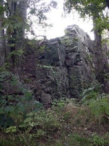
, its population is 426. Today, it is a small farming community with scattered businesses. Most of the natural steps, a geologic formation, still stand today and are used as a marker for river runners. The Natural Steps are not open to the public for viewing.
History
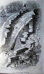
The small town was named after "two perfectly parallel vertical walls of sandstone, twenty feet apart, that jut out from the disintegrated soft slates, prominent conformity, descending step like, fifty-one feet from the top of the bank, where they first show themselves, to the edge of the lowest water-mark of the Arkansas River and can be seen running their course beneath the stream. These form a conspicuous landmark to boatman and travelers on the Arkansas River, and are known under the name of the "Natural Steps". Beginning in 1822, the local “Natural Steps” provided a convenient stop for Little Rock visitors to disembark for their hike to the mountain."
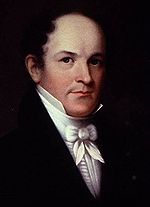
David Dale Owen
David Dale Owen was a prominent American geologist. He conducted the first geological surveys of Indiana, Kentucky, and Arkansas.David Dale was the third son of Robert Owen, a Welsh reformer who moved to the United States and established a social experiment at New Harmony, Indiana, where David...
(Principal Geologist
Geologist
A geologist is a scientist who studies the solid and liquid matter that constitutes the Earth as well as the processes and history that has shaped it. Geologists usually engage in studying geology. Geologists, studying more of an applied science than a theoretical one, must approach Geology using...
) in his Second Report of a Geological Reconnaissance of the Middle and Southern Counties of Arkansas (1859) ordered by Elias Nelson Conway
Elias Nelson Conway
Elias Nelson Conway was the fifth Governor of Arkansas.Elias Nelson Conway was brother to James Sevier Conway, the first governor of Arkansas. He and his family moved to Missouri. Conway attended Bonne Femme Academy in Boone County, Missouri.In 1833 Conway moved to Little Rock, Arkansas...
, Governor of Arkansas. He wrote, "In sight of the Pinnacle (Pinnacle Mountain State Park
Pinnacle Mountain State Park
Pinnacle Mountain State Park is located just northwest of Little Rock, Arkansas, USA, in the foothills of the Ouachita Mountains near Natural Steps, Arkansas on Arkansas Highway 300. The primary natural feature of the park is Pinnacle Mountain, elevation , which rises steeply above the Arkansas...
) on the Arkansas River, near the mouth of the Big Maumelle, are "The Natural Steps". I found to be forty feet above the Arkansas River, at its stage when I examined and sketched them, on May 30, 1859, but they are fifty-one feet above low-water mark."
"Seen from the River at a little distance, they have a wonderfully artificial appearance, looking like steps laid by regular masonry, and form, indeed, not only a remarkable feature in the landscape, but also a striking and unequivocal instance, of which Arkansas
Arkansas
Arkansas is a state located in the southern region of the United States. Its name is an Algonquian name of the Quapaw Indians. Arkansas shares borders with six states , and its eastern border is largely defined by the Mississippi River...
furnishes several, of strata tilted nearly on edge."
Arkansas River
The Arkansas River is a major tributary of the Mississippi River. The Arkansas generally flows to the east and southeast as it traverses the U.S. states of Colorado, Kansas, Oklahoma, and Arkansas. The river's initial basin starts in the Western United States in Colorado, specifically the Arkansas...
and show low-water depths across the channel at close intervals. They also showed gravel bars and shoals, ferry and landing locations, and other features important to river travel. The map was intended for navigation. In their maps, a drawing and location of the "Natural Steps" were included.
Native Americans
Fred O. Henker, M.D. wrote, "The first inhabitants of the Natural Steps area were Native Americans, Indians whose presence in the vicinity dates back possibly 10,000 years.""During early European explorations and the colonial period, local Native Americans, from about 1500 to the late 1700s, were the Quapaw
Quapaw
The Quapaw people are a tribe of Native Americans who historically resided on the west side of the Mississippi River in what is now the state of Arkansas.They are federally recognized as the Quapaw Tribe of Indians.-Government:...
meaning (down stream people)."
Naturalist Thomas Nuttall
Thomas Nuttall
Thomas Nuttall was an English botanist and zoologist, who lived and worked in America from 1808 until 1841....
wrote A Journal of Travels into the Arkansas Territory
Arkansas Territory
The Territory of Arkansas, initially organized as the Territory of Arkansaw, was an organized incorporated territory of the United States that existed from July 4, 1819 until June 15, 1836, when the final extent of the territory was admitted to the Union as the State of Arkansas.-History:The...
During the Year 1819. It was based on his travels from 1819-1821 to study botany along the Arkansas River. He also observed the Quapaw and other Native Americans. "A number of families were now about to settle, or rather take provisionary possession of the land purchased from the Osage
Osage Nation
The Osage Nation is a Native American Siouan-language tribe in the United States that originated in the Ohio River valley in present-day Kentucky. After years of war with invading Iroquois, the Osage migrated west of the Mississippi River to their historic lands in present-day Arkansas, Missouri,...
, situated along the banks of the Arkansa, from Frog bayou to the falls of the Verdigris..." Nuttall’s travels took him to the mouth of the Verdigris River
Verdigris River
The Verdigris River is a tributary of the Arkansas River in southeastern Kansas and northeastern Oklahoma in the United States. It is about long...
.
Thomas Nuttall found few Native Americans in the Natural Steps area in 1819.
French Explorers
The Pinnacle Mountain Community Post wrote:"History reveals the French were notorious traders with the Natives and perhaps many canoe or river raft pulled up and tied off in the area. Word has it that Bernard de la Harpe
Bernard de la Harpe
Bernard de la Harpe or Jean-Baptiste Bénard de la Harpe was a French explorer who is credited with the discovery of Little Rock, Arkansas. In 1722, la Harpe found two distinct rock formations on the Arkansas River, the smaller one the South bank he named La Petite Roche and the larger on the North...
spent some time in the area. The French explorers were coming down the river and when they rounded the bend, right near Palarm Creek, they named the twin peaks of Pinnacle Mountain Maumelle, which is French for a woman's breasts."
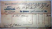
Steamboat Landing

The Arkansas Gazette
Arkansas Gazette
The Arkansas Gazette, known as the oldest newspaper west of the Mississippi River, and located from 1908 until its October 18, 1991 closing at the now historic Gazette Building, was for many years the newspaper of record for Little Rock and the State of Arkansas...
on May 19, 1878 wrote, "The excursion yesterday to Natural Steps on the steamer Maumelle under the auspices of the M.E. church and the management of its popular pastor, Rev. A.W. Decker, and Gen. Henry Rudd, was a great success, both pecuniarily and pleasurably. The boat left Little Rock promptly at 8:30 a.m. and after traversing our beautiful river, with its varied and picturesque scenery for about thirty miles duly reached its point of destination, the Natural Steps, where the excursionists disembarked and sought the shady groves in the vicinity, where they indulged in picnicking in the true and time-honored style; after when the Natural Steps were duly inspected and climbed and such getting up stairs you never did see."
A riverboat pilot on the Arkansas River in the late 19th century, R. E. Cross wrote in 1938:
"For years and years I rafted timber from Dardanelle and points below, to the old Freeman Lumber Company at Gleason, Ark., and to the Beebe Stave Company, located a few miles below Little Rock.
"There once lived a Dr. Moreland at Natural Steps who had a farm and a cotton gin, and in whose cottonseed house we slept many, many times after landing near Scott eddy. We cooked many a savory supper and breakfast in that old gin-lot. We would each dig a hole in the cottonseed and crawl in, wet clothes and all, and we slept very well."
.jpg)
The Battle of Palarm
This was a battle that began with the Brooks-Baxter WarBrooks-Baxter War
The Brooks–Baxter War was an armed conflict in Little Rock, Arkansas, in the United States, in 1874 between factions of the Republican Party over the disputed 1872 election for governor...
and occurred on the stern wheel steamboat "Hallie" on May 8, 1874. Palarm is a small community on the north side of the Arkansas River from Natural Steps.
Robert W. Meriwether of the Faulkner County Historical Society wrote:
"After stopping at Natural Steps to take on fuel wood, the "Hallie" was proceeding upstream. Suddenly a "terrific volley" of shots was fired at the steamer from behind rocks along the northern (eastern) bank of the river near Palarm. The Hallie Rifles returned the fire. The shooting continued for ten to fifteen minutes. One stray bullet pierced the supply pipe between the vessel's boiler and engine, thus cutting off its power, and the boat drifted downriver, out of gun range, and lodged on the southern (western) shore. The boat's captain, a pilot, and one rifleman were killed; the other pilot and three or four riflemen were wounded. One source stated that the Brooks regiment suffered one man killed and three wounded; another report was that five men were killed and "quite a number" wounded."
Ancient Fort
THE BENEDICT MANUSCRIPTWritten by R.W. Benedict Circa 1880
Discovery of Antiquarian Relics at Natural Steps, Pulaski County, Arkansas on South Side River
"About the year 1820 my father and family settled at Natural Steps, making a purchase of an improvement on public lands, of a Quapaw Indian named Heinman. I, at that time was about 8 years old and the events, that I am now to relate, are my own recollections and observations. About the year 1821, General Nix (General John Nicks) of the United States Army, was proceeding up the Arkansas river to supersede General (William) Bradford in the Indian Country of the far west, and to establish the military post of Fort Gibson
Fort Gibson
Fort Gibson, now located in Oklahoma and designated Fort Gibson Historical Site, guarded the American frontier in Indian Territory from 1824 until 1890...
. He was traveling in 3 Keel Boats, loaded with troops and Supplies (there being no Steamboats in those days). In passing our home, General Nix being an old acquaintance of my father John C. Benedict, stopped off to see his old friend. Previous to his arrival we had discovered, that upon the Spot where we were living, there had evidently been a Fort of great antiquity, and unknown to history. We invited the attention of General Nix to our discovery and after making a thorough examination, he pronounced the ruins to be unquestionably those of a very ancient raised Fort. Every evidence existed corroborative of the fact, that away back in the past centuries, there had been an important Fortification
Fortification
Fortifications are military constructions and buildings designed for defence in warfare and military bases. Humans have constructed defensive works for many thousands of years, in a variety of increasingly complex designs...
at this place, and that there had been a terrible fight engaged in, either at its capitulation and destruction, or at some time previous. The four walls of the fortification were still plainly visible, and their outlines well defined – and General Nix stepped their straight lines in measuring them. That this Fort must have been of great antiquity was evidenced by the fact that at this time immense trees were growing in the area inside the walls. Wild cherry trees, full 2 foot (0.6096 m) in diameter, and 50 or 60 feet (18.3 m) to their first branches and as straight as an arrow. The walls were built of rock, and from the quantity of them these walls must have been of great size, but they were now torn down and covered with debris. In the immediate vicinity of the Fort, on a high elevation and far above any possible chance of overflow, there was to be seen a large excavation, now become a pond, grown up with "Menockonock" weeds and other water plants. All the surroundings proved that this excavation was of great age, contemporary with that of the Fort, and from its situation on the high lands, it could have been made but for one purpose, and that to procure the material for the embankment of the fort, or else a water receptacle for the uses of the Fort. Outside of the walls, and along the bank of the river, we found immense quantities of "Mashed or flattened bullets", of various sizes and shapes, indicating that they had been shot into something, evidently the stone walls of the Fort, and had been mashed by the contact. Here were also found Stone Hatchets, and arrowheads, all pointing unmistakably to the conclusion that a sanguinary battle had been fought here at sometime. Inside of the walls, while plowing, we found great quantities of lead that had been melted, and also an immense Indian Axe of solid stone, perfect in form, save that the handle had been broken off. This was a very interesting relic, and affords room for much thought and conjecture, as it was of extraordinary size, and uncommon shape, being four times as large as anything of the kind we had ever seen before or since. Nothing of its form had ever been seen in this country before, and the verdict of all was that it must have been brought from some far-off country, by an invading force. In or about the Fort was also found another most remarkable relic, which was "a solid piece of Brass", weighing exactly 5 pounds, 5 or 6 inches (152.4 mm) long, square in shape, having on either of its four sides, three distinct deep impressions about the size and shape of an old fashioned watch case, the centre impressions being the largest, and on either end a similar impression covering the entire end, save a margin on the outside. All of these impressions were of like shape, only differing in size. No letters, or characters appeared thereon, but perfectly smooth surfaces, save the impressions spoken of. This brass nugget, was examined by many of the most scientific men of Arkansas, in that day, and none were ever able to throw any light on it, as to whence it came, or for what purposes it could have been utilized. It remained in my father's possession for many years, he always having refused to dispose of it, though frequently urged to do so, and it finally very mysteriously disappeared, and we could never get any trace of it."
"About four miles above this spot, one Joshua Chandler found a piece, or rather a slab, of lead of peculiar shape, and singularly situated. It was found about 18 feet (5.5 m) under what appeared to be the virgin soil, which had been some distance from the river bank, but the wash and caving for many years had reached it, and when found its edge was alone discernible, protruding from the washed bank. Upon excavating it, he found it to be a slab of lead, smooth on the faces and edges, about 8 by 14 inches (355.6 mm) in size, 2 inches thick, and weighing exactly 77 pounds. I remember the weight distinctly, as Chandler carried it to Little Rock and sold it to Joseph Henderson, a merchant, who was a brother-in-law of Chester Ashley, and received therefor 77 one pound bars of lead. This slab bore distinct signs on its faces of having been struck with an axe or tomahawk. It had a hole in each corner about 1 by ½ inch, just about the size that would be necessary for a strap to pass through in order to pack it. It was found in a vein of black clay and a little removed from it, on one side, was a bed of ashes and fire-coals, in same vein of clay, plainly indicating that this was over the surface of the ground and that the accumulation of ages had thus covered it with 18 feet (5.5 m) of soil. Here again is ample room for speculation and conjecture. Was this the remains of a camp-fire? Was this slab of lead cast here at this time? If so, by whom, for what purpose, and why was it abandoned? From my studies in connection with these discoveries, I am convinced that there certainly was, at sometime, an important Fort at this place, garrisoned by somebody; that said Fort was attacked by invaders; that it was subsequently demolished either before or after capitulation; and that history fails to record any information thereof."
"It is a matter of history that "De-Soto" Hernando de Soto (explorer)
Hernando de Soto (explorer)
Hernando de Soto was a Spanish explorer and conquistador who, while leading the first European expedition deep into the territory of the modern-day United States, was the first European documented to have crossed the Mississippi River....
, passed through this identical country in his search for the "Golden land". Crossing the Arkansas river near or at Pine Bluff, he continued his explorations up to near the head-waters of the Arkansas, and returning passed over nearly the same route; that he had many desperate fights with the Indians; that he, on this exploration established three Forts, and that historians have so far failed to locate the 3rd Fort. May not this be the lost Fort of De-Sota? I think so, can any proof be brought to the contrary."
Courtesy of and Transcribed June 2000
By B. Collins
Great-great-granddaughter of R.W. Benedict. The family of Mr. Benedict still have the original manuscript, written in the 1800s, in their possession.
The ancient fort has not been located and now it is believed that the fort was likely built by Bernard de la Harpe.
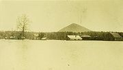
Flood of 1927
This picture was taken of the Great Mississippi Flood of 1927Great Mississippi Flood of 1927
The Great Mississippi Flood of 1927 was the most destructive river flood in the history of the United States.-Events:The flood began when heavy rains pounded the central basin of the Mississippi in the summer of 1926. By September, the Mississippi's tributaries in Kansas and Iowa were swollen to...
in Natural Steps. It shows Natural Steps knee deep in Arkansas River water from this point, all the way to Pinnacle Mountain. Seen in the background are the Natural Steps train depot, the Moreland commissary and Pinnacle Mountain.
The Mainard House
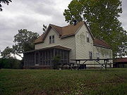
The Moreland House
The first Moreland home was built in the 1870s and was nothing more than a shack. It was later converted into a barn and garage once the new home was built.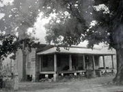
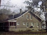
Great Mississippi Flood of 1927
The Great Mississippi Flood of 1927 was the most destructive river flood in the history of the United States.-Events:The flood began when heavy rains pounded the central basin of the Mississippi in the summer of 1926. By September, the Mississippi's tributaries in Kansas and Iowa were swollen to...
, the basement of the home was filled with water from the Arkansas River and the only way to get access to the home was by boat. The picture above, Flood of 1927, was taken from the house. The house did not survive a fire in the late 1970s.
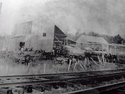
Train Depot
At one time, Natural Steps had a small train depot off Maple Ave. "The Memphis and Choctaw Railroad was built through the south edge of town in 1898 with a small station building beside the track." "Railroad ties, oak, and cypress lumber, and wooden shingles were shipped out on the railroad starting in 1907, from depots at the towns of Pinnacle and Natural Steps. Several smaller sawmills called "gopher mills" operated in the area, and the timber industry, along with farming, provided the first major work for early residents." The old depot was destroyed in the early 1900s.Businesses
Cotton
Cotton is a soft, fluffy staple fiber that grows in a boll, or protective capsule, around the seeds of cotton plants of the genus Gossypium. The fiber is almost pure cellulose. The botanical purpose of cotton fiber is to aid in seed dispersal....
was the main cash crop when they first started their farming operation and as time went on they moved into Soybeans. The farm, at one time, had a cotton gin
Cotton gin
A cotton gin is a machine that quickly and easily separates cotton fibers from their seeds, a job formerly performed painstakingly by hand...
, a blacksmith shop, a sawmill
Sawmill
A sawmill is a facility where logs are cut into boards.-Sawmill process:A sawmill's basic operation is much like those of hundreds of years ago; a log enters on one end and dimensional lumber exits on the other end....
, and a commissary
Commissary
A commissary is someone delegated by a superior to execute a duty or an office; in a formal, legal context, one who has received power from a legitimate superior authority to pass judgment in a certain cause or to take information concerning it.-Word history:...
along the Rock Island Railroad, but were torn down in 1963. The commissary was destroyed in the early 1900s. The Moreland family still farms in the area today.
"The commissary was also used as the first post office for the area. The post office was established on September 6, 1880, with Dr. Duval as postmaster. However, the post office lasted only thirteen months, closing on October 3, 1881. A second post office was established on March 15, 1901, with Henry P. Clay as postmaster, succeeded in 1902 by Little Bart Moreland, in 1910 by Walter A. Nowlin, and in 1913 by Little Bart Moreland. The post office was discontinued on August 31, 1925, with Little Bart Moreland the last postmaster."
Pinnacle Realty, Inc. was started in Natural Steps in 1974 and continues to sell real estate in the area. Their office is located off Arkansas Hwy 300.
Churches
The Natural Steps Baptist Church was established in 1913 and built beside the Natural Steps Cemetery. The original church burned in 1962 and was rebuilt along Hwy 300 where it still stands today.The Natural Steps Methodist Church was written about by the Arkansas Gazette
Arkansas Gazette
The Arkansas Gazette, known as the oldest newspaper west of the Mississippi River, and located from 1908 until its October 18, 1991 closing at the now historic Gazette Building, was for many years the newspaper of record for Little Rock and the State of Arkansas...
on November 12, 1936.
"The village of Natural Steps is on the Rock Island Railroad on a bluff overlooking the Arkansas River, about 18 miles northwest of Little Rock. It received its name from natural rock steps leading from the bluff down to the river. The river bottom lands are very fertile, but mostly cultivated by colored people so that the white population of this community is very small. It is not known just when the first Methodist church was organized at Natural Steps. The records show that in December, 1884, a deed was given to the property where the present church is now located. The property was given jointly by Mr. and Mrs. R.C. Newson and Dr. and Mrs. T. M. Duvall, citizens of this community at that time. Soon after the deed was executed a church was built and used, both, as a Methodist church and a school house. After about ten years the church was burned, supposedly, by some one who had fallen out with the school teacher. Soon after this the present church was built under the pastorate of Rev. J.F. Taylor who has given a large part of his long ministry to the mountain territory lying between Little Rock and Hot Springs and who is at present serving two churches out in this territory that were left off the regular appointments. This church was originally called Shady Grove.
Our church at Natural Steps now has a membership of 15 with a church building valued at $1,000.
The information concerning this church was given by Mrs. J.E. Moreland, whose deceased husband was one of the original trustees of the church property. Mrs. Moreland now lives in Little Rock and belongs to Winfield Church."
The old Methodist Church burned to the ground, in the late 1940s, during a volunteer clean-up day at the Natural Steps Cemetery. A spark from one of the fires landed on the roof of the church and by the time the locals realized, it was too late.
Cemeteries
Natural Steps Cemetery Est. Sept 1, 1861Bailor Cemetery African American Cemetery
School
"Beginning in the late 1884, Natural Steps built the Natural Steps Methodist Church that was originally known as Shady Grove Church. It occupied a one-room church and school house. The school closed in the late 1920's. That building burned ten years after it was built and was replaced with another. This building burned in the 1940s." Written by Fred O. Henker, M.D.Historic Bridge
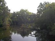
Truss bridge
A truss bridge is a bridge composed of connected elements which may be stressed from tension, compression, or sometimes both in response to dynamic loads. Truss bridges are one of the oldest types of modern bridges...
was built on the old Arkansas HWY 300 to cross the Little Maumelle River. It is on the Historic Bridges of the United States (Maumelle River AR 300 Bridge) for Pulaski County, Arkansas. The bridge still stands in the shadow of Pinnacle Mountain, but was made obsolete by a new bridge in 1981. Today, it is only open to pedestrians for fishing and is part of the 223 mile long Ouachita National Recreation Trail
Ouachita National Recreation Trail
Ouachita National Recreation Trail is a long, continuous hiking trail through the Ouachita Mountainsof Oklahoma and Arkansas.The trail is primarily a hiking and backpacking trail, but about 2/3 of the trail are available to mountain bikers....
.
State Park
.jpg)
Pinnacle Mountain State Park
Pinnacle Mountain State Park is located just northwest of Little Rock, Arkansas, USA, in the foothills of the Ouachita Mountains near Natural Steps, Arkansas on Arkansas Highway 300. The primary natural feature of the park is Pinnacle Mountain, elevation , which rises steeply above the Arkansas...
was established as a state park in 1973. "The Fulk family, who owned the largest tract, including Pinnacle Mountain, also supported the plan to establish it as a state park." It is located just south of Natural Steps on Arkansas Highway 300 and is heavily visited by climbers, hikers, and picnickers. "The primary natural feature of the 2000 acres (8.1 km²) park is Pinnacle Mountain, elevation 1011 feet (308.2 m), which rises steeply above the Arkansas River Valley, at an elevation of 300 feet (91.4 m)." The mountain is on the northeast corner of the Ouachita Mountains
Ouachita Mountains
The Ouachita Mountains are a mountain range in west central Arkansas and southeastern Oklahoma. The range's subterranean roots may extend as far as central Texas, or beyond it to the current location of the Marathon Uplift. Along with the Ozark Mountains, the Ouachita Mountains form the U.S...
.
"The cone-shaped peak was first mentioned in the book, A Journal of Travels into the Arkansas Territory During the Year 1819, written by naturalist Thomas Nuttall. During the colonial and early American periods, the mountain was known as “Mamelle” mountain. “Mamelle” is a name commonly applied in the French-speaking parts of the world to a breast or any breast-shaped hill. Over time, the term “Mamelle” became “Maumelle,” which is a name now applied to the Big Maumelle and Little Maumelle rivers, Lake Maumelle, and two different communities in the area."
"Beginning in 1822, the local “Natural Steps” provided a convenient stop for Little Rock visitors to disembark for their hike to the mountain. Visitation increased with the construction of the local railroad in the 1890s. With common use of the automobile and improved roads in the early 20th century, climbing the pinnacle became even more popular and accessible."
"The park provides environmental protection and conservation for a relatively unspoiled tract of hills, forests, and waterways near a growing metropolitan area. It also provides recreational and educational facilities and programs for visitors. The park’s diverse habitats range from high upland rocky peaks, upland forests, and wetlands and bottomlands along the Big and Little Maumelle rivers. The various habitats provide many outdoor recreational and educational opportunities. Included in these are canoe and boat tours led by park interpreters. Also available are educational tours, self-guided trails, wayside outdoor exhibits, four major vistas, and opportunities for natural solitude."
"Pinnacle Mountain is a day-use-only park with an emphasis on preservation rather than development. Gates at Pinnacle Mountain State Park close one hour after sunset. Park facilities include picnic sites, two standard pavilions, two launch ramps, eight hiking trails, and two overlooks. The park visitor center overlooking the Arkansas River includes exhibits, A/V programs, a meeting room, and gift shop."
"The eight hiking trails range from the easy one-half-mile paved Kingfisher trail to the two-mile Rocky Valley trail. The Ouachita National Recreation Trail begins at the visitor center and proceeds 223 miles through the Ouachita Mountains, ending at Talimena State Park in southeastern Oklahoma. The first three miles are within the park."

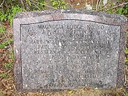
Masonic Stone
Legend
In the 1940s, residents of Natural Steps began dynamiting the steps in search of ConfederateConfederate States of America
The Confederate States of America was a government set up from 1861 to 1865 by 11 Southern slave states of the United States of America that had declared their secession from the U.S...
gold lying beneath the massive stones. The legend is, a Confederate Gunboat was sunk at the natural steps so the Union Army
Union Army
The Union Army was the land force that fought for the Union during the American Civil War. It was also known as the Federal Army, the U.S. Army, the Northern Army and the National Army...
, that just claimed Little Rock, couldn't take possession of the Confederate gold on board. The thought being, the steps would be a marker for where the gold laid and the Confederates could come back later and reclaim it. Three Confederate soldiers died in the explosion that sank the gunboat and are buried in the Natural Steps Cemetery. In the late 19th century, one of the locals, waiting to catch a steamboat at the foot of the steps, found a $5 gold piece. No gold was ever found in the 1940s and the steps were partially destroyed by the dynamite.
Another legend was given to us by Bart Moreland Sr. who was born in Natural Steps. "The old story goes that Jesse James
Jesse James
Jesse Woodson James was an American outlaw, gang leader, bank robber, train robber, and murderer from the state of Missouri and the most famous member of the James-Younger Gang. He also faked his own death and was known as J.M James. Already a celebrity when he was alive, he became a legendary...
and his gang spent the night, in Natural Steps, and robbed a stage coach in Benton, on the road to Hot Springs
Hot Springs, Arkansas
Hot Springs is the 10th most populous city in the U.S. state of Arkansas, the county seat of Garland County, and the principal city of the Hot Springs Metropolitan Statistical Area encompassing all of Garland County...
, the next day." Bart Sr. then said, "Yeah, that was the talk, then, I was born 1899, and it was the 1800s that Jesse James spent the night there." When asked who told him, "Oh, several, my dad and mother for one, or two." The old cabin that Jesse James was said to have stayed in, no longer exists.
Written in the Pinnacle Mountain Community Post.
The Natural Steps Ghost
On the darkest of nights in late October, a woman in white can be seen walking in the Natural Steps Cemetery. She is first seen in the northeast section of the cemetery where the old Natural Steps Baptist Church sat before it burned. From there, she is seen heading north into the woods towards the natural steps. Once she arrives at the steps, she follows the rock steps down into the Arkansas River and is never seen again.The legend is that the woman in white is Martha Sanders. A young bride who lost her husband, Gustavus Sanders, days after their wedding. Gustavus Sanders, died in October 1880 from an unknown disease that took many lives in the small community. But before his death, Gustavus and Martha decided to wed at their favorite meeting spot, at the top of the natural steps, overlooking the Arkansas River. Unfortunately, the honeymoon was short for the young couple because just days later he was dead and was laid to rest behind the old wooden church. The grief was too great for Martha and after his funeral she just disappeared, never seen again by family or friends. It is believed that she is the woman in white and that she took her life by jumping into the Arkansas River from the Natural Steps.
The woman in white has been seen by a few in the community. The older generations still tell their stories of Gustavus and Martha Sanders.
External links
- Find-A-Grave profile for David Dale Owens
- Find-A-Grave profile for Lt. Col John Nicks
- Find-A-Grave profile for William Bradford
- Find-A-Grave profile for Elias Nelson Conway
- Pinnacle Mountain State Park
- The Battle of Palarm
- The Battle of Palarm drawing
- Pinnacle Realty Inc.
- 1870 Arkansas River Survey
- 1870 Map of the Arkansas River
- Archaeological Digs