

National Register of Historic Places listings in West Side Chicago
Encyclopedia
There are 54 sites in the National Register of Historic Places
listings in West Side Chicago, out of 326 listings in the City of Chicago
. The West Side is defined for this article as the area north of the Chicago Sanitary and Ship Canal
, south of Fullerton Avenue, west of the Chicago River
and east of the western city limits. One site, Logan Square Boulevards Historic District, spans a border and is included also in listings on the North Side
.
.
National Register of Historic Places
The National Register of Historic Places is the United States government's official list of districts, sites, buildings, structures, and objects deemed worthy of preservation...
listings in West Side Chicago, out of 326 listings in the City of Chicago
Chicago
Chicago is the largest city in the US state of Illinois. With nearly 2.7 million residents, it is the most populous city in the Midwestern United States and the third most populous in the US, after New York City and Los Angeles...
. The West Side is defined for this article as the area north of the Chicago Sanitary and Ship Canal
Chicago Sanitary and Ship Canal
The Chicago Sanitary and Ship Canal, historically known as the Chicago Drainage Canal, is the only shipping link between the Great Lakes and the Mississippi River system, by way of the Illinois and Des Plaines Rivers...
, south of Fullerton Avenue, west of the Chicago River
Chicago River
The Chicago River is a system of rivers and canals with a combined length of that runs through the city of the same name, including its center . Though not especially long, the river is notable for being the reason why Chicago became an important location, as the link between the Great Lakes and...
and east of the western city limits. One site, Logan Square Boulevards Historic District, spans a border and is included also in listings on the North Side
National Register of Historic Places listings in North Side Chicago
There are 81 sites in the National Register of Historic Places listings in North Side Chicago, out of 326 listings in the City of Chicago. The North Side is defined for this article as the area west of Lake Michigan, north of North Avenue and east of the Chicago River plus the area north of...
.
West Side Chicago listings on the National Register
The listed properties are distributed across 9 of the 77 well-defined community areas of ChicagoCommunity areas of Chicago
Community areas in Chicago refers to the work of the Social Science Research Committee at University of Chicago which has unofficially divided the City of Chicago into 77 community areas. These areas are well-defined and static...
.
| Landmark name | Image | Date listed | Location | Neighborhood | Description | |
|---|---|---|---|---|---|---|
| 1 | 7th District Police Station 7th District Police Station The 7th District Police Station, or Maxwell Street Station in Chicago, Illinois was built in 1888 in response to the need for increased police presence in "Bloody Maxwell", known colloquially as "the Wickedest Police District in the World." The neighborhood, a changing melting pot of Irish,... |
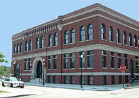 |
943-949 W. Maxwell Street Maxwell Street Maxwell Street is an east-west street in Chicago, Illinois that intersects with Halsted Street just south of Roosevelt Road. It runs at 1330 South in the numbering system running from 500 West to 1126 West. The Maxwell Street neighborhood is considered part of the Near West Side and is one of the... 41°51′52"N 87°39′2"W |
Near West Side Near West Side, Chicago The Near West Side, one of the 77 defined community areas of Chicago, is located , adjacent to the downtown central business district . The rich history of the Near West Side of Chicago has its genesis in the Hull House phenomenon... |
Romanesque style police station Police station A police station or station house is a building which serves to accommodate police officers and other members of staff. These buildings often contain offices and accommodation for personnel and vehicles, along with locker rooms, temporary holding cells and interview/interrogation rooms.- Facilities... that served in pacifying the "Bloody Maxwell" area from 1888 to 1988. |
|
| 2 | Austin Historic District | Roughly bounded by W. Ohio Street, N. Waller Avenue, N. Parkside Avenue, W. West End Avenue, & N. Mayfield Avenue & W. Corcoran Place 41°53′12"N 87°46′12"W |
Austin Austin, Chicago Austin, located on the West Side of Chicago, Illinois, is the largest of the city's 77 officially defined community areas, followed by Lake View. Its eastern boundary is the Belt Railway located just east of Cicero Avenue. Its northernmost border is the Milwaukee District/West Line... |
|||
| 3 | Austin Town Hall Park Historic District Austin Town Hall Park Austin Town Hall Park is a park at 5610 W. Lake Street in the Austin neighborhood of Chicago, Illinois. The site was formerly used for the town hall of Cicero Township. The Austin subdivision of Cicero was annexed to Chicago in 1899, and the town hall site eventually became part of the Chicago Park... |
 |
Roughly bounded by W. Lake Street Lake Street (Chicago) Lake Street is an east-west arterial road in Chicago and its suburbs. Part of Lake Street is designated as U.S. Route 20. Lake Street begins in the city of Chicago and travels west and slightly north to the Chicago suburbs. It ends at the eastern terminus of the Elgin Bypass around Elgin, where... , N. Central Avenue, N. Parkside Avenue, and W. Race Avenue 41°53′18"N 87°45′57"W |
Austin Austin, Chicago Austin, located on the West Side of Chicago, Illinois, is the largest of the city's 77 officially defined community areas, followed by Lake View. Its eastern boundary is the Belt Railway located just east of Cicero Avenue. Its northernmost border is the Milwaukee District/West Line... |
||
| 4 | Automatic Electric Company Building | 1001 W. Van Buren Street 41°52′42"N 87°39′8"W |
Near West Side Near West Side, Chicago The Near West Side, one of the 77 defined community areas of Chicago, is located , adjacent to the downtown central business district . The rich history of the Near West Side of Chicago has its genesis in the Hull House phenomenon... |
|||
| 5 | Building at 900 West Lake Street | 900 W. Lake Street Lake Street (Chicago) Lake Street is an east-west arterial road in Chicago and its suburbs. Part of Lake Street is designated as U.S. Route 20. Lake Street begins in the city of Chicago and travels west and slightly north to the Chicago suburbs. It ends at the eastern terminus of the Elgin Bypass around Elgin, where... 41°53′9"N 87°39′0"W |
Near West Side Near West Side, Chicago The Near West Side, one of the 77 defined community areas of Chicago, is located , adjacent to the downtown central business district . The rich history of the Near West Side of Chicago has its genesis in the Hull House phenomenon... |
|||
| 6 | Central Park Theater | 3531-39 W. Roosevelt Road Roosevelt Road Roosevelt Road is a major east-west thoroughfare in the city of Chicago, Illinois, and its western suburbs. It is 1200 South in the city's street numbering system, but only one mile south of Madison Street... 41°51′59"N 87°42′26"W |
North Lawndale North Lawndale, Chicago North Lawndale located on the west side of Chicago, Illinois, is one of the well-defined community areas in the city of Chicago.-History:... |
|||
| 7 | Anton Cermak House | 2348 S. Millard Ave. 41°50′54"N 87°42′59"W |
South Lawndale South Lawndale, Chicago South Lawndale is located on the west side of the city of Chicago, Illinois, is one of 77 well-defined Chicago community areas. The neighborhood is predominantly Mexican.- Little Village :... |
|||
| 8 | Chicago and North Western Railway Power House | 211 N. Clinton Street 41°53′18"N 87°38′54"W |
Near West Side Near West Side, Chicago The Near West Side, one of the 77 defined community areas of Chicago, is located , adjacent to the downtown central business district . The rich history of the Near West Side of Chicago has its genesis in the Hull House phenomenon... |
|||
| 9 | Chicago Telephone Company Kedzie Exchange | 17 S. Homan Avenue 41°52′49"N 87°42′39"W |
East Garfield Park East Garfield Park, Chicago East Garfield Park is a community area located on the west side of Chicago, Illinois, USA. It is part of the Chicago West Side area. Located directly in the path of gentrification heading westward from the Loop, East Garfield Park was named one of America's most "up and coming neighborhoods" in the... |
|||
| 10 | Church of the Epiphany | 201 S. Ashland Avenue 41°52′43"N 87°39′59"W |
Near West Side Near West Side, Chicago The Near West Side, one of the 77 defined community areas of Chicago, is located , adjacent to the downtown central business district . The rich history of the Near West Side of Chicago has its genesis in the Hull House phenomenon... |
|||
| 11 | Columbus Park Columbus Park (Chicago) Columbus Park, located on the west side of Chicago, Illinois in the Austin neighborhood, is bounded by West Adams Street, South Austin Boulevard, South Central Avenue, and the Eisenhower Expressway, to which it lost nine acres when the expressway was constructed. The remnant park is part of the... |
 |
500 S. Central Avenue 41°52′28"N 87°46′10"W |
Austin Austin, Chicago Austin, located on the West Side of Chicago, Illinois, is the largest of the city's 77 officially defined community areas, followed by Lake View. Its eastern boundary is the Belt Railway located just east of Cicero Avenue. Its northernmost border is the Milwaukee District/West Line... |
||
| 12 | Cook County Hospital Administration Building | 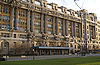 |
1835 W. Harrison Street 41°52′33"N 87°40′22"W |
Near West Side Near West Side, Chicago The Near West Side, one of the 77 defined community areas of Chicago, is located , adjacent to the downtown central business district . The rich history of the Near West Side of Chicago has its genesis in the Hull House phenomenon... |
||
| 13 | Creamery Package Manufacturing Company Building | 1245 W. Washington Blvd. 41°52′58"N 87°39′30"W |
Near West Side Near West Side, Chicago The Near West Side, one of the 77 defined community areas of Chicago, is located , adjacent to the downtown central business district . The rich history of the Near West Side of Chicago has its genesis in the Hull House phenomenon... |
|||
| 14 | Dawson Brothers Plant | 517-519 N. Halsted Street Halsted Street Halsted Street is a major north-south street in the American city of Chicago, Illinois.-Location:In Chicago's grid system, Halsted street marks 800 West, one mile west of State Street, from Grace Street in Lakeview south to the city limits at the Little Calumet River in West Pullman... 41°53′31"N 87°38′50"W |
West Town West Town, Chicago West Town, located in Chicago, Illinois, northwest of the Loop, is one of 77 officially designated Chicago community areas. Its name may refer to Western Avenue, which was the city's western boundary at the time of West Town's settlement, but more likely was a convenient abstraction by the creators... |
|||
| 15 | East Village Historic District | Bounded by W. Division Street Division Street (Chicago) Division Street is a major east-west street in Chicago, Illinois, located at 1200 North . Division Street begins in the Gold Coast neighborhood near Lake Shore Drive, passes through Polonia Triangle at Milwaukee Avenue into Wicker Park and continues to Chicago's city limits and into the city's... , W. Chicago Avenue, N. Hermitage Avenue and N. Damen Avenue 41°53′58.68"N 87°40′25.61"W |
West Town West Town, Chicago West Town, located in Chicago, Illinois, northwest of the Loop, is one of 77 officially designated Chicago community areas. Its name may refer to Western Avenue, which was the city's western boundary at the time of West Town's settlement, but more likely was a convenient abstraction by the creators... |
|||
| 16 | First Congregational Church of Austin | .jpg) |
5701 W. Midway Park 41°53′19"N 87°46′5"W |
Austin Austin, Chicago Austin, located on the West Side of Chicago, Illinois, is the largest of the city's 77 officially defined community areas, followed by Lake View. Its eastern boundary is the Belt Railway located just east of Cicero Avenue. Its northernmost border is the Milwaukee District/West Line... |
||
| 17 | Jennie Foley Building | 626-628 S. Racine Avenue 41°52′24"N 87°39′25"W |
Near West Side Near West Side, Chicago The Near West Side, one of the 77 defined community areas of Chicago, is located , adjacent to the downtown central business district . The rich history of the Near West Side of Chicago has its genesis in the Hull House phenomenon... |
|||
| 18 | Garfield Park |  |
100 N. Central Park Avenue 41°53′11"N 87°42′58"W |
East Garfield Park East Garfield Park, Chicago East Garfield Park is a community area located on the west side of Chicago, Illinois, USA. It is part of the Chicago West Side area. Located directly in the path of gentrification heading westward from the Loop, East Garfield Park was named one of America's most "up and coming neighborhoods" in the... |
||
| 19 | Abraham Groesbeck House | 1304 W. Washington Boulevard 41°52′59"N 87°39′36"W |
Near West Side Near West Side, Chicago The Near West Side, one of the 77 defined community areas of Chicago, is located , adjacent to the downtown central business district . The rich history of the Near West Side of Chicago has its genesis in the Hull House phenomenon... |
|||
| 20 | Guyon Hotel | 4000 W. Washington Boulevard 41°52′55"N 87°43′35"W |
West Garfield Park West Garfield Park, Chicago West Garfield Park located on the west side of Chicago, Illinois, is one of 77 officially designated Chicago community areas.West Garfield Park had 86 foreclosures in 2006 and 87 foreclosures in 2007, resulting in 67.7 foreclosures per square mile in 2006 and 70.1 foreclosures per square mile in... |
|||
| 21 | Holy Trinity Russian Orthodox Cathedral and Rectory | 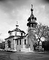 |
1117-1127 N. Leavitt Street 41°54′7"N 87°40′55"W |
West Town West Town, Chicago West Town, located in Chicago, Illinois, northwest of the Loop, is one of 77 officially designated Chicago community areas. Its name may refer to Western Avenue, which was the city's western boundary at the time of West Town's settlement, but more likely was a convenient abstraction by the creators... |
||
| 22 | Home Bank and Trust Company | 1200 N. Ashland Avenue 41°54′14"N 87°40′5"W |
West Town West Town, Chicago West Town, located in Chicago, Illinois, northwest of the Loop, is one of 77 officially designated Chicago community areas. Its name may refer to Western Avenue, which was the city's western boundary at the time of West Town's settlement, but more likely was a convenient abstraction by the creators... |
|||
| 23 | Hull House Hull House Hull House is a settlement house in the United States that was co-founded in 1889 by Jane Addams and Ellen Gates Starr. Located in the Near West Side of , Hull House opened its doors to the recently arrived European immigrants. By 1911, Hull House had grown to 13 buildings. In 1912 the Hull... |
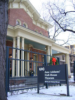 |
800 S. Halsted Street Halsted Street Halsted Street is a major north-south street in the American city of Chicago, Illinois.-Location:In Chicago's grid system, Halsted street marks 800 West, one mile west of State Street, from Grace Street in Lakeview south to the city limits at the Little Calumet River in West Pullman... 41°52′17"N 87°38′49"W |
Near West Side Near West Side, Chicago The Near West Side, one of the 77 defined community areas of Chicago, is located , adjacent to the downtown central business district . The rich history of the Near West Side of Chicago has its genesis in the Hull House phenomenon... |
||
| 24 | Humboldt Park Humboldt Park (Chicago park) Humboldt Park is a park located on the northwest side of Chicago, Illinois at 1400 North Sacramento Avenue.The park was named for Alexander von Humboldt, a German naturalist. William Le Baron Jenney began developing the park in the 1870s, molding a flat prairie landscape into a "pleasure ground"... |
 |
Roughly bounded by N. Sacramento Boulevard and W. Augusta Boulevard, and N. Kedzie Avenue, W. North Avenue and N. California Avenue and W. Division Street Division Street (Chicago) Division Street is a major east-west street in Chicago, Illinois, located at 1200 North . Division Street begins in the Gold Coast neighborhood near Lake Shore Drive, passes through Polonia Triangle at Milwaukee Avenue into Wicker Park and continues to Chicago's city limits and into the city's... 41°54′12"N 87°42′10"W |
West Town West Town, Chicago West Town, located in Chicago, Illinois, northwest of the Loop, is one of 77 officially designated Chicago community areas. Its name may refer to Western Avenue, which was the city's western boundary at the time of West Town's settlement, but more likely was a convenient abstraction by the creators... |
||
| 25 | International Tailoring Company Building International Tailoring Company Building International Tailoring Company Building is a historic building that was listed on the National Register on April 18, 2008.It has been used by the School of the Art Institute of Chicago for exhibit space, and, as of 2005 was being converted to residential condos. It is located at 847 W. Jackson... |
847 W. Jackson Boulevard 41°52′39.74"N 87°38′56.91"W |
Near West Side Near West Side, Chicago The Near West Side, one of the 77 defined community areas of Chicago, is located , adjacent to the downtown central business district . The rich history of the Near West Side of Chicago has its genesis in the Hull House phenomenon... |
|||
| 26 | Jewish People's Institute | 3500 W. Douglas Boulevard 41°51′47"N 87°42′47"W |
North Lawndale North Lawndale, Chicago North Lawndale located on the west side of Chicago, Illinois, is one of the well-defined community areas in the city of Chicago.-History:... |
|||
| 27 | K-Town Historic District | Bounded on the north by W. Cullerton Street; on the south by W. Cermak Road Cermak Road Cermak Road, formerly 22nd Street, is a major east-west artery on Chicago's south side and western suburbs. It is named for assassinated Chicago mayor Anton Cermak.-Points of interest:... , on the west by S. Kostner Avenue, and on the east by S. Pulaski Road Pulaski Road (Chicago) Pulaski Road is a major north-south thoroughfare in the city of Chicago, at 4000 W., or exactly five miles west of State Street. It is named after revolutionary war hero Casimir Pulaski... 41°51′11"N 87°43′47"W |
South Lawndale South Lawndale, Chicago South Lawndale is located on the west side of the city of Chicago, Illinois, is one of 77 well-defined Chicago community areas. The neighborhood is predominantly Mexican.- Little Village :... |
|||
| 28 | Patrick J. King House | 3234 W. Washington Boulevard 41°52′58"N 87°42′27"W |
East Garfield Park East Garfield Park, Chicago East Garfield Park is a community area located on the west side of Chicago, Illinois, USA. It is part of the Chicago West Side area. Located directly in the path of gentrification heading westward from the Loop, East Garfield Park was named one of America's most "up and coming neighborhoods" in the... |
|||
| 29 | Henry E. Legler Regional Branch of the Chicago Public Library | 115 S. Pulaski Road Pulaski Road (Chicago) Pulaski Road is a major north-south thoroughfare in the city of Chicago, at 4000 W., or exactly five miles west of State Street. It is named after revolutionary war hero Casimir Pulaski... 41°52′46"N 87°43′31"W |
West Garfield Park West Garfield Park, Chicago West Garfield Park located on the west side of Chicago, Illinois, is one of 77 officially designated Chicago community areas.West Garfield Park had 86 foreclosures in 2006 and 87 foreclosures in 2007, resulting in 67.7 foreclosures per square mile in 2006 and 70.1 foreclosures per square mile in... |
|||
| 30 | Lindemann and Hoverson Company Showroom and Warehouse | 2620 W. Washington Boulevard 41°52′58.6"N 87°41′31.4"W |
East Garfield Park East Garfield Park, Chicago East Garfield Park is a community area located on the west side of Chicago, Illinois, USA. It is part of the Chicago West Side area. Located directly in the path of gentrification heading westward from the Loop, East Garfield Park was named one of America's most "up and coming neighborhoods" in the... |
|||
| 31 | Logan Square Boulevards Historic District | 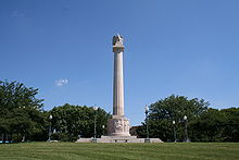 |
W. Logan Boulevard, Logan Square, N. Kedzie Boulevard, Palmer Square, and N. Humboldt Boulevard 41°55′12"N 87°41′58"W |
Logan Square Logan Square, Chicago Logan Square is one of the 77 city-designated community areas located on the near northwest side of the City of Chicago. The name, used here to describe the community area defined by U.S. census tracts, also applies to one of a number of smaller, more loosely defined residential neighborhoods... |
Three boulevards connected by two parks, on both the North Side and West Sides. | |
| 32 | Lou Mitchell's Restaurant |  |
565 W. Jackson Boulevard 41°52′38"N 87°38′30"W |
Near West Side Near West Side, Chicago The Near West Side, one of the 77 defined community areas of Chicago, is located , adjacent to the downtown central business district . The rich history of the Near West Side of Chicago has its genesis in the Hull House phenomenon... |
||
| 33 | Midwest Athletic Club | 6 N. Hamlin Avenue 41°52′52"N 87°43′16"W |
West Garfield Park West Garfield Park, Chicago West Garfield Park located on the west side of Chicago, Illinois, is one of 77 officially designated Chicago community areas.West Garfield Park had 86 foreclosures in 2006 and 87 foreclosures in 2007, resulting in 67.7 foreclosures per square mile in 2006 and 70.1 foreclosures per square mile in... |
|||
| 34 | Notre Dame de Chicago | 1338 W. Flournoy Street 41°52′24"N 87°39′39"W |
Near West Side Near West Side, Chicago The Near West Side, one of the 77 defined community areas of Chicago, is located , adjacent to the downtown central business district . The rich history of the Near West Side of Chicago has its genesis in the Hull House phenomenon... |
|||
| 35 | Otis Elevator Company Factory Building | 1435 W. 15th Street and 1501 S. Laflin Street 41°51′41.2"N 87°39′44.2"W |
Near West Side Near West Side, Chicago The Near West Side, one of the 77 defined community areas of Chicago, is located , adjacent to the downtown central business district . The rich history of the Near West Side of Chicago has its genesis in the Hull House phenomenon... |
|||
| 36 | Pilsen Historic District Pilsen Historic District The Pilsen Historic District is an historic district located in the Pilsen neighborhood of Chicago. Pilsen is a neighborhood made up of the residential sections of the Lower West Side community area of Chicago. In the late 19th century Pilsen was inhabited by Czech immigrants who named the... |
Roughly bounded by W. 16th Street, W. Cermak Road Cermak Road Cermak Road, formerly 22nd Street, is a major east-west artery on Chicago's south side and western suburbs. It is named for assassinated Chicago mayor Anton Cermak.-Points of interest:... , S. Halsted Street Halsted Street Halsted Street is a major north-south street in the American city of Chicago, Illinois.-Location:In Chicago's grid system, Halsted street marks 800 West, one mile west of State Street, from Grace Street in Lakeview south to the city limits at the Little Calumet River in West Pullman... and S. Western Avenue Western Avenue (Chicago) Western Avenue is the longest continuous street within the city of Chicago at in length. Western Avenue extends south as a continuous road to the Dixie Highway at Sibley Boulevard in Dixmoor, giving the road a total length of . However, Western Avenue extends intermittently through the... 41°51′14"N 87°40′13"W |
Lower West Side Lower West Side, Chicago Lower West Side located on the west side of Chicago, Illinois, is one of 77 well-defined Chicago community areas.-Government and infrastructure:The United States Postal Service operates the Pilsen Post Office at 1859 South Ashland Avenue.... |
|||
| 37 | Produce Terminal Cold Storage Company Building | 1550 S. Blue Island Avenue Blue Island Avenue Blue Island Avenue is a diagonal street in the city of Chicago, Illinois that once led to a ridge of land that early pioneers gave the name "Blue Island" because at a distance it looked like an island in the prairie. The blue color was attributed to atmospheric scattering or to blue flowers growing... 41°51′42"N 87°39′28"W |
Near West Side Near West Side, Chicago The Near West Side, one of the 77 defined community areas of Chicago, is located , adjacent to the downtown central business district . The rich history of the Near West Side of Chicago has its genesis in the Hull House phenomenon... |
|||
| 38 | Pulaski Park and Fieldhouse | 1419 W. Blackhawk Street 41°54′21"N 87°39′47"W |
West Town West Town, Chicago West Town, located in Chicago, Illinois, northwest of the Loop, is one of 77 officially designated Chicago community areas. Its name may refer to Western Avenue, which was the city's western boundary at the time of West Town's settlement, but more likely was a convenient abstraction by the creators... |
|||
| 39 | St. Ignatius College Prep | 1076 W. Roosevelt Road Roosevelt Road Roosevelt Road is a major east-west thoroughfare in the city of Chicago, Illinois, and its western suburbs. It is 1200 South in the city's street numbering system, but only one mile south of Madison Street... 41°52′3"N 87°39′6"W |
Near West Side Near West Side, Chicago The Near West Side, one of the 77 defined community areas of Chicago, is located , adjacent to the downtown central business district . The rich history of the Near West Side of Chicago has its genesis in the Hull House phenomenon... |
|||
| 40 | St. Matthew Evangelical Lutheran School | 2101-2107 W. 21st Street 41°51′13"N 87°40′43"W |
Lower West Side Lower West Side, Chicago Lower West Side located on the west side of Chicago, Illinois, is one of 77 well-defined Chicago community areas.-Government and infrastructure:The United States Postal Service operates the Pilsen Post Office at 1859 South Ashland Avenue.... |
|||
| 41 | St. Patrick's Roman Catholic Church | .jpg) |
718 W. Adams Street 41°52′45"N 87°38′40"W |
Near West Side Near West Side, Chicago The Near West Side, one of the 77 defined community areas of Chicago, is located , adjacent to the downtown central business district . The rich history of the Near West Side of Chicago has its genesis in the Hull House phenomenon... |
||
| 42 | Schoenhofen Brewery Historic District Schoenhofen Brewery Historic District The Schoenhofen Brewery Historic District is centered around the former site of the Peter Schoenhofen Brewing Company at 18th and Canalport Avenue in the Pilsen neighborhood of Chicago, Illinois.... |
 |
Roughly bounded by W. 16th Street, W. 18th Street, S. Canal Street, and S. Clinton Street 41°51′31"N 87°38′22"W |
Lower West Side Lower West Side, Chicago Lower West Side located on the west side of Chicago, Illinois, is one of 77 well-defined Chicago community areas.-Government and infrastructure:The United States Postal Service operates the Pilsen Post Office at 1859 South Ashland Avenue.... |
||
| 43 | Sears, Roebuck and Company Complex | 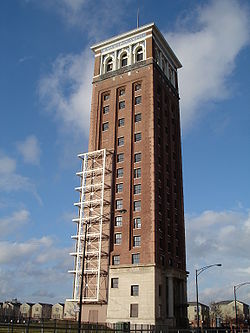 |
925 S. Homan Avenue 41°52′10"N 87°42′42"W |
East Garfield Park East Garfield Park, Chicago East Garfield Park is a community area located on the west side of Chicago, Illinois, USA. It is part of the Chicago West Side area. Located directly in the path of gentrification heading westward from the Loop, East Garfield Park was named one of America's most "up and coming neighborhoods" in the... |
||
| 44 | Shedd Park Fieldhouse | 3660 W. 23rd Street 41°51′1"N 87°43′1"W |
South Lawndale South Lawndale, Chicago South Lawndale is located on the west side of the city of Chicago, Illinois, is one of 77 well-defined Chicago community areas. The neighborhood is predominantly Mexican.- Little Village :... |
|||
| 45 | J. P. Smith Shoe Company Plant | 671-699 N. Sangamon Avenue and 901-921 W. Huron Street 41°53′41"N 87°39′3"W |
West Town West Town, Chicago West Town, located in Chicago, Illinois, northwest of the Loop, is one of 77 officially designated Chicago community areas. Its name may refer to Western Avenue, which was the city's western boundary at the time of West Town's settlement, but more likely was a convenient abstraction by the creators... |
|||
| 46 | South Water Market | Bounded by W. 14th Place, the 16th Street rail embankment, S. Racine Avenue, and S. Morgan Street 41°51′42"N 87°39′15"W |
Near West Side Near West Side, Chicago The Near West Side, one of the 77 defined community areas of Chicago, is located , adjacent to the downtown central business district . The rich history of the Near West Side of Chicago has its genesis in the Hull House phenomenon... |
|||
| 47 | Story-Camp Rowhouses | 1526-1528 W. Monroe Street 41°52′48"N 87°39′57"W |
Near West Side Near West Side, Chicago The Near West Side, one of the 77 defined community areas of Chicago, is located , adjacent to the downtown central business district . The rich history of the Near West Side of Chicago has its genesis in the Hull House phenomenon... |
|||
| 48 | Tri-Taylor Historic District | Roughly bounded by S. Claremont Avenue, W. Harrison Street, S. Oakley Avenue, W. Polk Street, W. Ogden Avenue Ogden Avenue (Chicago) Ogden Avenue is an arterial street extending from the Near West Side of Chicago to Aurora, Illinois.The street follows the route of the Southwestern Plank Road, which opened in 1848 across swampy terrain between Chicago and Riverside, Illinois, and was extended to Naperville by 1851.The 1909 Plan... , and W. Roosevelt Road Roosevelt Road Roosevelt Road is a major east-west thoroughfare in the city of Chicago, Illinois, and its western suburbs. It is 1200 South in the city's street numbering system, but only one mile south of Madison Street... ; also roughly bounded on the north by Oakley, Harrison, and Claremont Streets, and on the southeast by Taylor and Oakley Streets 41°52′13"N 87°41′0"W |
Near West Side Near West Side, Chicago The Near West Side, one of the 77 defined community areas of Chicago, is located , adjacent to the downtown central business district . The rich history of the Near West Side of Chicago has its genesis in the Hull House phenomenon... |
Second set of boundaries represents a boundary increase of | ||
| 49 | Union Park Congregational Church and Carpenter Chapel | 1613 W. Washington Boulevard 41°53′6"N 87°40′3"W |
Near West Side Near West Side, Chicago The Near West Side, one of the 77 defined community areas of Chicago, is located , adjacent to the downtown central business district . The rich history of the Near West Side of Chicago has its genesis in the Hull House phenomenon... |
Now known as First Baptist Congregational Church; built in 1871; severely damaged in the February 2, 2011 blizzard | ||
| 50 | Union Park Hotel | 1519-1521 W Warren Blvd. 41°52′55.62"N 87°39′58.02"W |
Near West Side Near West Side, Chicago The Near West Side, one of the 77 defined community areas of Chicago, is located , adjacent to the downtown central business district . The rich history of the Near West Side of Chicago has its genesis in the Hull House phenomenon... |
|||
| 51 | United States Post Office-Chicago |  |
433 W. Van Buren Street 41°52′34"N 87°38′19"W |
Near West Side Near West Side, Chicago The Near West Side, one of the 77 defined community areas of Chicago, is located , adjacent to the downtown central business district . The rich history of the Near West Side of Chicago has its genesis in the Hull House phenomenon... |
||
| 52 | Seth Warner House | 631 N. Central Avenue 41°53′31"N 87°45′54"W |
Austin Austin, Chicago Austin, located on the West Side of Chicago, Illinois, is the largest of the city's 77 officially defined community areas, followed by Lake View. Its eastern boundary is the Belt Railway located just east of Cicero Avenue. Its northernmost border is the Milwaukee District/West Line... |
|||
| 53 | Jackson Boulevard Historic District Jackson Boulevard District and Extension The West Jackson Boulevard District in Chicago, Illinois, also known as West Jackson Historic District, was listed on the National Register of Historic Places in 1978. It was earlier designed as a Chicago Landmark, in 1976, and expanded as Jackson Boulevard District and Extension in 1997. The... |
Roughly bounded by S. Laflin Avenue, S. Ashland Avenue, W. Adams Street, and W. Van Buren Street; also 1513 W. Adams Street 41°52′39"N 87°39′55"W |
Near West Side Near West Side, Chicago The Near West Side, one of the 77 defined community areas of Chicago, is located , adjacent to the downtown central business district . The rich history of the Near West Side of Chicago has its genesis in the Hull House phenomenon... |
Second set of boundaries represents a boundary increase of | ||
| 54 | Wicker Park Historic District Wicker Park Historic District The Wicker Park Historic District is a historic district in Chicago, Illinois that was listed on the National Register of Historic Places in 1979. Its area included, in 1979, 827 contributing buildings.... |
Roughly bounded by N. Wood, W. Crystal and N. Caton Streets, N. Claremont and W. North Avenues 41°54′26"N 87°40′20"W |
West Town West Town, Chicago West Town, located in Chicago, Illinois, northwest of the Loop, is one of 77 officially designated Chicago community areas. Its name may refer to Western Avenue, which was the city's western boundary at the time of West Town's settlement, but more likely was a convenient abstraction by the creators... |
Key
| NRHP-listed | |
| ∞ | NRHP-listed Historic district Historic district A historic district or heritage district is a section of a city which contains older buildings considered valuable for historical or architectural reasons. In some countries, historic districts receive legal protection from development.... |
| * | National Historic Landmark National Historic Landmark A National Historic Landmark is a building, site, structure, object, or district, that is officially recognized by the United States government for its historical significance... and NRHP-listed |
| ∞ | National Historic Landmark National Historic Landmark A National Historic Landmark is a building, site, structure, object, or district, that is officially recognized by the United States government for its historical significance... and NRHP-listed Historic district Historic district A historic district or heritage district is a section of a city which contains older buildings considered valuable for historical or architectural reasons. In some countries, historic districts receive legal protection from development.... |
See also
- List of Chicago Landmarks
- List of Registered Historic Places in Illinois
- List of National Historic Landmarks in Illinois
- National Register of Historic Places listings in Central ChicagoNational Register of Historic Places listings in Central ChicagoCurrently there are 114 National Register of Historic Places listings in Central Chicago, out of 326 listings in the City of Chicago. Central Chicago includes 3 of the 77 well-defined community areas of Chicago: the historic business and cultural center of Chicago, the Loop, as well as the Near...
- National Register of Historic Places listings in North Side ChicagoNational Register of Historic Places listings in North Side ChicagoThere are 81 sites in the National Register of Historic Places listings in North Side Chicago, out of 326 listings in the City of Chicago. The North Side is defined for this article as the area west of Lake Michigan, north of North Avenue and east of the Chicago River plus the area north of...
- National Register of Historic Places listings in South Side ChicagoNational Register of Historic Places listings in South Side ChicagoThere are 78 sites on the National Register of Historic Places listings in South Side Chicago, out of 326 listings in the City of Chicago. The South Side is defined for this article as the area west of Lake Michigan and south of 26th Street and the Chicago Sanitary and Ship Canal to the southern...
- National Register of Historic Places listings in Central Chicago
External links
- Chicago Listing on the National Register of Historic Places, February 10, 2009, City of Chicago, Richard M. Daley, Mayor.
- Cook County, Illinois listings at NRHP.COM, a private site repackaging government NRHP data
- National Register Information System, National Park Service.