

National Register of Historic Places listings in Gloucester, Massachusetts
Encyclopedia
This is a list of the National Register of Historic Places listings in Gloucester, Massachusetts.
This is intended to be a complete list of the properties and districts on the National Register of Historic Places
in Gloucester
, Massachusetts
, United States
. The locations of National Register properties and districts for which the latitude and longitude coordinates are included below, may be seen in a Google map.
Essex County
, of which Gloucester is a part, is the location of 455 properties and districts listed on the National Register. Gloucester itself is the location of 33 of these properties and districts.
This is intended to be a complete list of the properties and districts on the National Register of Historic Places
National Register of Historic Places
The National Register of Historic Places is the United States government's official list of districts, sites, buildings, structures, and objects deemed worthy of preservation...
in Gloucester
Gloucester, Massachusetts
Gloucester is a city on Cape Ann in Essex County, Massachusetts, in the United States. It is part of Massachusetts' North Shore. The population was 28,789 at the 2010 U.S. Census...
, Massachusetts
Massachusetts
The Commonwealth of Massachusetts is a state in the New England region of the northeastern United States of America. It is bordered by Rhode Island and Connecticut to the south, New York to the west, and Vermont and New Hampshire to the north; at its east lies the Atlantic Ocean. As of the 2010...
, United States
United States
The United States of America is a federal constitutional republic comprising fifty states and a federal district...
. The locations of National Register properties and districts for which the latitude and longitude coordinates are included below, may be seen in a Google map.
Essex County
Essex County, Massachusetts
-National protected areas:* Parker River National Wildlife Refuge* Salem Maritime National Historic Site* Saugus Iron Works National Historic Site* Thacher Island National Wildlife Refuge-Demographics:...
, of which Gloucester is a part, is the location of 455 properties and districts listed on the National Register. Gloucester itself is the location of 33 of these properties and districts.
Current listings
| Landmark name | Image | Date listed | Location | Summary | |
|---|---|---|---|---|---|
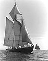
| 1 | ADVENTURE (schooner) Adventure (schooner) The 1926 schooner Adventure is one of the last of the famous Grand Banks fishing schooners of Gloucester, Massachusetts. She is one of only two "knockabout" fishing schooners surviving.Adventure was declared a National Historic Landmark in 1994.... |
 |
State Fish Pier, Gloucester Inner Harbor 42°36′52.47"N 70°39′5.88"W |
||
| 2 | Annisquam Bridge Annisquam Bridge Annisquam Bridge is a historic bridge in Annisquam, Massachusetts, a village within the city of Gloucester.Built in 1861 to cross Lobster Cove, the bridge was added to the National Historic Register of Historic Places in 1983. It is a wood pile bridge.... |
Carries Bridgewater St. over Lobster Cove between Washington St. and River Rd. 42°39′18"N 70°40′32.4"W |
|||
| 3 | Annisquam Harbor Light Station | Wigwam Pt. 42°39′49"N 70°40′31"W |
|||
| 4 | Babson-Alling House Babson-Alling House Babson-Alling House is a historic colonial house at 245 Washington Street in Gloucester, Massachusetts.It was built in 1740 and added to the National Register of Historic Places in 1996.... |
245 Washington St. 42°37′20"N 70°40′42"W |
|||
| 5 | Beauport Beauport, Sleeper-McCann House Beauport, also known as Sleeper-McCann House, Little Beauport, or Henry Davis Sleeper House, is a historic house in Gloucester, Massachusetts. It was built starting in 1907 as the summer home of interior decorator and antique collector Henry Davis Sleeper... |
Eastern Point Boulevard 42°35′28"N 70°39′38"W |
|||
| 6 | Beauport Beauport, Sleeper-McCann House Beauport, also known as Sleeper-McCann House, Little Beauport, or Henry Davis Sleeper House, is a historic house in Gloucester, Massachusetts. It was built starting in 1907 as the summer home of interior decorator and antique collector Henry Davis Sleeper... |
75 Eastern Point Boulevard 42°35′28"N 70°39′38"W |
|||
| 7 | Central Gloucester Historic District Central Gloucester Historic District Central Gloucester Historic District is a historic district with boundaries to Middle, Main, Center, Hancock, Short, Prospect and Pleasant Streets in Gloucester, Massachusetts.It was added to the National Register of Historic Places in 1982.... |
Roughly bounded by Middle, Main, Center, Hancock, Short, Prospect, and Pleasant Sts. 42°36′46"N 70°39′55"W |
|||
| 8 | Davis-Freeman House Davis-Freeman House Davis-Freeman House is a historic house at 302 Essex Street in Gloucester, Massachusetts.It was built in 1709 and added to the National Register of Historic Places in 1990.... |
302 Essex St. 42°36′38"N 70°42′32"W |
|||
| 9 | Dyke-Wheeler House Dyke-Wheeler House Dyke-Wheeler House is a historic colonial house at 144 Wheeler Street in Gloucester, Massachusetts.It was built in 1720 and added to the National Register of Historic Places in 1990.... |
144 Wheeler St. 42°38′36"N 70°40′51"W |
|||
| 10 | East Gloucester Square Historic District East Gloucester Square Historic District East Gloucester Square Historic District is a historic district on E. Main Street in Gloucester, Massachusetts, roughly bounded by Inner Harbor, Smith Cove, Wonson Cove, and Mt. Pleasant Avenue.... |
E. Main St., roughly bounded by Inner Harbor, Smith Cove, Woonson Cove, and Mt. Pleasant Ave. 42°36′28"N 70°39′7"W |
|||
| 11 | Eastern Point Light Station | 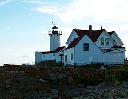 |
Eastern Pt. 42°34′38"N 70°39′52"W |
||
| 12 | First Parish Burial Ground | 122-R Centennial Ave. 42°37′2.64"N 70°40′23.16"W |
|||
| 13 | FRANK A. PALMER AND LOUISE B. CRARY (Shipwreck) | Address Restricted | |||
| 14 | Front Street Block Front Street Block Front Street Block is a historic block in the West End at 55-71 Main Street in Gloucester, Massachusetts.The block was built in 1831 and added to the National Register of Historic Places in 1974.... |
West End, 55-71 Main St. 42°36′45"N 70°39′55"W |
|||
| 15 | Gloucester City Hall Gloucester City Hall Gloucester City Hall is a historic city hall at Dale Avenue in Gloucester, Massachusetts.It was built in 1869-1871 and added to the National Register of Historic Places in 1973.-External Links:*... |
Dale Ave. 42°36′50"N 70°39′47"W |
|||
| 16 | Gloucester Fisherman's Memorial Gloucester Fisherman's Memorial Gloucester Fisherman's Memorial is a historic memorial cenotaph sculpture on South Stacy Boulevard, near entrance of Stacy Esplanade in Gloucester, Massachusetts, built in 1925.... |
S. Stacy Boulevard near the entrance to Stacy Esplanade 42°36′36"N 70°40′17"W |
|||
| 17 | Gloucester Net and Twine Company Gloucester Net and Twine Company Gloucester Net and Twine Company is a historic factory at Maplewood Avenue, southeast of the junction of Maplewood Avenue and Grove Street in Gloucester, Massachusetts.... |
Maplewood Ave. at the southeastern junction of Maplewood Ave. and Grove St. 42°37′15"N 70°40′7"W |
|||
| 18 | Hammond Castle Hammond Castle Hammond Castle is located on the coast of Gloucester, Massachusetts. The castle, which was constructed between 1926 and 1929, was the home and laboratory of John Hays Hammond, Jr. Mr. Hammond was an inventor who was a pioneer in remote control and held over four hundred patents... |
80 Hesperus Ave. 42°35′6"N 70°41′35"W |
|||
| 19 | Edward Harraden House Edward Harraden House Edward Harraden House is a historic house at 12—14 Leonard Street in Gloucester, Massachusetts.The house was built in 1660 and added to the National Register of Historic Places in 1990.... |
12-14 Leonard St. 42°39′13"N 70°40′47"W |
|||
| 20 | William Haskell House William Haskell House William Haskell House is a historic house at 11 Lincoln Street in Gloucester, Massachusetts.... |
11 Lincoln St. 42°37′38"N 70°44′18"W |
|||
| 21 | Ella Proctor Herrick House Ella Proctor Herrick House Ella Proctor Herrick House is a historic house at 189 Concord Street in Gloucester, Massachusetts.... |
189 Concord St. 42°38′33"N 70°43′26"W |
|||
| 22 | JOFFRE (shipwreck) | Off the Gloucester coastline | |||
| 23 | Fitz Henry Lane House | Harbor side of Rogers St. 42°36′41"N 70°39′36"W |
|||
| 24 | Norwood-Hyatt House Norwood-Hyatt House Norwood-Hyatt House is a historic house at 704 Washington Street in Gloucester, Massachusetts. Alpheus Hyatt purchased the house in 1878. He started the first marine biological laboratory in the country here in Annisquam, Massachusetts, a village of Gloucester. It later moved to Woods Hole and was... |
704 Washington St. 42°39′4"N 70°40′26"W |
|||
| 25 | Oak Grove Cemetery Oak Grove Cemetery (Gloucester, Massachusetts) Oak Grove Cemetery is a historic cemetery founded in 1854, and bounded by Derby, Washington, and Grove Sts., and Maplewood Avenue in Gloucester, Massachusetts.It was added to the National Register of Historic Places in 1854.... |
Bounded by Derby, Washington, and Grove Sts., and Maplewood Ave. 42°37′10"N 70°40′14"W |
|||
| 26 | Our Lady of Good Voyage Church Our Lady of Good Voyage Church Our Lady of Good Voyage Church is a historic Roman Catholic church at 136-144 Prospect Street and 2-4 Taylor Street in Gloucester, Massachusetts.The church was built in 1914 and added to the National Historic Register in 1990.... |
136-144 Prospect St. and 2-4 Taylor St. 42°37′1"N 70°39′28"W |
|||
| 27 | PORTLAND (Shipwreck and Remains) Portland (Shipwreck) The Portland is a historic shipwreck in Gloucester, Massachusetts. The S.S. Portland was built by New England Shipbuilding Co. in 1889 and sank in the Portland Gale of 1898 off of Cape Ann, killing 192 people.... |
Address Restricted | |||
| 28 | Puritan House Puritan House Puritan House is a historic house at 3 Washington Street and 2 Main Street in Gloucester, Massachusetts.The house was built in 1810 and added to the National Historic Register in 1976.... |
3 Washington St. and 2 Main St. 42°36′41"N 70°40′0"W |
|||
| 29 | George O. Stacy House George O. Stacy House George O. Stacy House is a historic house at 107 Atlantic Road in Gloucester, Massachusetts.... |
107 Atlantic Rd. 42°36′30"N 70°38′3"W |
|||
| 30 | Ten Pound Island Light Ten Pound Island Light Ten Pound Island Light is a historic lighthouse in Gloucester Harbor in Gloucester, Massachusetts.The lighthouse was built in 1881 and added to the National Register of Historic Places in 1988.... |
Gloucester Harbor 42°36′6.8"N 70°39′55.8"W |
|||
| 31 | Webster-Lane House Webster-Lane House Webster-Lane House is a historic house at 304 Main Street in Gloucester, Massachusetts.... |
304 Main St. 42°36′56"N 70°39′27"W |
|||
| 32 | White-Ellery House White-Ellery House The White-Ellery House is a historic house located in Gloucester, Massachusetts. It is on the National Register of Historic Places. It is owned and operated by the Cape Ann Museum whose headquarters is located at 27 Pleasant Street in Gloucester.-History:... |
 |
244 Washington St. 42°37′23"N 70°40′34"W |
||
| 33 | Whittemore House | 179 Washington St. 42°37′7"N 70°40′28"W |
See also
- List of National Historic Landmarks in Massachusetts
- National Register of Historic Places listings in Massachusetts
- National Register of Historic Places listings in Essex County, Massachusetts