

National Register of Historic Places listings in Cameron County, Texas
Encyclopedia
List of Registered Historic Places in Angelina County, Texas
This is intended to be a complete list of properties and districts listed on the National Register of Historic Places
in Cameron County, Texas
. The locations of National Register properties and districts (at least for all showing latitude and longitude coordinates below) may be seen in a Google map by clicking on "Map of all coordinates".
|--
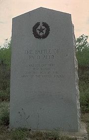
! | 21
| Palo Alto Battlefield National Historical Park
| |
|
| 6.3 miles N of Brownsville at intersection of FM 1847 and FM 511
26°1′4.39"N 97°28′50.22"W
| Brownsville
|
|}
This is intended to be a complete list of properties and districts listed on the National Register of Historic Places
National Register of Historic Places
The National Register of Historic Places is the United States government's official list of districts, sites, buildings, structures, and objects deemed worthy of preservation...
in Cameron County, Texas
Cameron County, Texas
Cameron County is the southernmost county located in the U.S. state of Texas. In 2010, its population was 406,220. Its county seat is Brownsville. Cameron was founded in 1848...
. The locations of National Register properties and districts (at least for all showing latitude and longitude coordinates below) may be seen in a Google map by clicking on "Map of all coordinates".
|--
! | 21
| Palo Alto Battlefield National Historical Park
|
| 6.3 miles N of Brownsville at intersection of FM 1847 and FM 511
26°1′4.39"N 97°28′50.22"W
| Brownsville
Brownsville, Texas
Brownsville is a city in the southernmost tip of the state of Texas, in the United States. It is located on the northern bank of the Rio Grande, directly north and across the border from Matamoros, Tamaulipas, Mexico. Brownsville is the 16th largest city in the state of Texas with a population of...
|
|}