

National Parks in the Republic of Ireland
Encyclopedia
National Parks in the Republic of Ireland is a link page for any national park
in the Republic of Ireland
.
Table below shows the name of the national park and in which county of Ireland it is located. The first park which was established in Ireland was the Killarney
located in County Kerry
in 1932. Since then a further 5 National Parks have been opened; the most recently being Ballycroy
in County Mayo
; this is also the largest national park in the Republic of Ireland
at 110 km2 in size. The smallest being the Burren National Park
in The Burren
located in County Clare
at only 15 km2 in size.
National park
A national park is a reserve of natural, semi-natural, or developed land that a sovereign state declares or owns. Although individual nations designate their own national parks differently A national park is a reserve of natural, semi-natural, or developed land that a sovereign state declares or...
in the Republic of Ireland
Republic of Ireland
Ireland , described as the Republic of Ireland , is a sovereign state in Europe occupying approximately five-sixths of the island of the same name. Its capital is Dublin. Ireland, which had a population of 4.58 million in 2011, is a constitutional republic governed as a parliamentary democracy,...
.
Table below shows the name of the national park and in which county of Ireland it is located. The first park which was established in Ireland was the Killarney
Killarney National Park
Killarney National Park is located beside the town of Killarney, County Kerry, Ireland. It was the first national park established in Ireland, created when Muckross Estate was donated to the Irish state in 1932...
located in County Kerry
County Kerry
Kerry means the "people of Ciar" which was the name of the pre-Gaelic tribe who lived in part of the present county. The legendary founder of the tribe was Ciar, son of Fergus mac Róich. In Old Irish "Ciar" meant black or dark brown, and the word continues in use in modern Irish as an adjective...
in 1932. Since then a further 5 National Parks have been opened; the most recently being Ballycroy
Ballycroy National Park
Ballycroy National Park is located in the Owenduff/Nephin Mountains area of the Barony of Erris in northwest County Mayo, Ireland. It is one of the largest expanses of peatland in Europe, consisting of 117.79 square kilometres of Atlantic blanket bog. It is a unique habitat with a diverse flora and...
in County Mayo
County Mayo
County Mayo is a county in Ireland. It is located in the West Region and is also part of the province of Connacht. It is named after the village of Mayo, which is now generally known as Mayo Abbey. Mayo County Council is the local authority for the county. The population of the county is 130,552...
; this is also the largest national park in the Republic of Ireland
Republic of Ireland
Ireland , described as the Republic of Ireland , is a sovereign state in Europe occupying approximately five-sixths of the island of the same name. Its capital is Dublin. Ireland, which had a population of 4.58 million in 2011, is a constitutional republic governed as a parliamentary democracy,...
at 110 km2 in size. The smallest being the Burren National Park
The Burren
The Burren is a karst-landscape region or alvar in northwest County Clare, in Ireland. It is one of the largest karst landscapes in Europe. The region measures approximately 250 square kilometres and is enclosed roughly within the circle made by the villages Ballyvaughan, Kinvara, Tubber, Corofin,...
in The Burren
The Burren
The Burren is a karst-landscape region or alvar in northwest County Clare, in Ireland. It is one of the largest karst landscapes in Europe. The region measures approximately 250 square kilometres and is enclosed roughly within the circle made by the villages Ballyvaughan, Kinvara, Tubber, Corofin,...
located in County Clare
County Clare
-History:There was a Neolithic civilisation in the Clare area — the name of the peoples is unknown, but the Prehistoric peoples left evidence behind in the form of ancient dolmen; single-chamber megalithic tombs, usually consisting of three or more upright stones...
at only 15 km2 in size.
| National Park | Photo | Region | Land Area | Established |
|---|---|---|---|---|
| Ballycroy Ballycroy National Park Ballycroy National Park is located in the Owenduff/Nephin Mountains area of the Barony of Erris in northwest County Mayo, Ireland. It is one of the largest expanses of peatland in Europe, consisting of 117.79 square kilometres of Atlantic blanket bog. It is a unique habitat with a diverse flora and... |
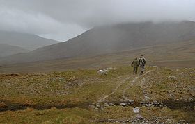 |
County Mayo County Mayo County Mayo is a county in Ireland. It is located in the West Region and is also part of the province of Connacht. It is named after the village of Mayo, which is now generally known as Mayo Abbey. Mayo County Council is the local authority for the county. The population of the county is 130,552... |
110 km² (42.5 sq mi) | 1998 |
| Connemara Connemara National Park Connemara National Park is one of six National Parks in the Republic of Ireland that are managed by the National Parks and Wildlife Service of the Department of the Environment, Heritage and Local Government. It is located in the west of Ireland within County Galway.-History:Connemara National... |
 |
County Galway County Galway County Galway is a county in Ireland. It is located in the West Region and is also part of the province of Connacht. It is named after the city of Galway. Galway County Council is the local authority for the county. There are several strongly Irish-speaking areas in the west of the county... |
30 km² (11.6 sq mi) | 1990 |
| Glenveagh Glenveagh Glenveagh — covering 170 square kilometres of hillside above Glenveagh Castle on the shore of Lough Veagh , some 20 km from Gweedore in County Donegal, Ireland — forms the heart of the Glenveagh National Park , the second largest national park in Ireland... |
County Donegal County Donegal County Donegal is a county in Ireland. It is part of the Border Region and is also located in the province of Ulster. It is named after the town of Donegal. Donegal County Council is the local authority for the county... |
170 km² (65.6 sq mi) | 1984 | |
| Killarney Killarney National Park Killarney National Park is located beside the town of Killarney, County Kerry, Ireland. It was the first national park established in Ireland, created when Muckross Estate was donated to the Irish state in 1932... |
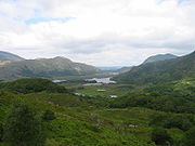 |
County Kerry County Kerry Kerry means the "people of Ciar" which was the name of the pre-Gaelic tribe who lived in part of the present county. The legendary founder of the tribe was Ciar, son of Fergus mac Róich. In Old Irish "Ciar" meant black or dark brown, and the word continues in use in modern Irish as an adjective... |
105 km² (40.5 sq mi) | 1932 |
| The Burren The Burren The Burren is a karst-landscape region or alvar in northwest County Clare, in Ireland. It is one of the largest karst landscapes in Europe. The region measures approximately 250 square kilometres and is enclosed roughly within the circle made by the villages Ballyvaughan, Kinvara, Tubber, Corofin,... |
County Clare County Clare -History:There was a Neolithic civilisation in the Clare area — the name of the peoples is unknown, but the Prehistoric peoples left evidence behind in the form of ancient dolmen; single-chamber megalithic tombs, usually consisting of three or more upright stones... |
15 km² (5.8 sq mi) | 1998 | |
| Wicklow Mountains Wicklow Mountains The Wicklow Mountains form the largest continuous upland area in Ireland. They occupy the whole centre of County Wicklow and stretch outside its borders into Counties Carlow, Wexford and Dublin. Where the mountains extend into County Dublin, they are known locally as the Dublin Mountains... |
 |
County Wicklow County Wicklow County Wicklow is a county in Ireland. It is part of the Mid-East Region and is also located in the province of Leinster. It is named after the town of Wicklow, which derives from the Old Norse name Víkingalág or Wykynlo. Wicklow County Council is the local authority for the county... |
205 km² (79.2 sq mi) | 1991 |