
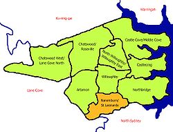
Naremburn, New South Wales
Encyclopedia
Suburb
The word suburb mostly refers to a residential area, either existing as part of a city or as a separate residential community within commuting distance of a city . Some suburbs have a degree of administrative autonomy, and most have lower population density than inner city neighborhoods...
on the lower North Shore
North Shore (Sydney)
The North Shore is an informal term used to describe the primarily residential area of northern metropolitan Sydney, in the state of New South Wales, Australia. The term usually refers to the suburbs located on the north shore of Sydney Harbour between Middle Harbour and the Lane Cove River, up to...
of Sydney
Sydney
Sydney is the most populous city in Australia and the state capital of New South Wales. Sydney is located on Australia's south-east coast of the Tasman Sea. As of June 2010, the greater metropolitan area had an approximate population of 4.6 million people...
, New South Wales
New South Wales
New South Wales is a state of :Australia, located in the east of the country. It is bordered by Queensland, Victoria and South Australia to the north, south and west respectively. To the east, the state is bordered by the Tasman Sea, which forms part of the Pacific Ocean. New South Wales...
, Australia
Australia
Australia , officially the Commonwealth of Australia, is a country in the Southern Hemisphere comprising the mainland of the Australian continent, the island of Tasmania, and numerous smaller islands in the Indian and Pacific Oceans. It is the world's sixth-largest country by total area...
. Naremburn is located 6 kilometres north of the Sydney central business district
Sydney central business district
The Sydney central business district is the main commercial centre of Sydney, New South Wales, Australia. It extends southwards for about 3 kilometres from Sydney Cove, the point of first European settlement. Its north–south axis runs from Circular Quay in the north to Central railway station in...
, in the local government area of the City of Willoughby
City of Willoughby
The City of Willoughby is a Local Government Area on the North Shore of Sydney, in the state of New South Wales, Australia. It is located 6 km north of the Sydney central business district....
.
History
The suburb name dates to the 1800s but its origin cannot be verified. Naremburn was originally known as Central Township. The earliest land grants in the area were granted to Humphrey Evans and Peter Dargan in 1794.Commercial area and transport
Naremburn has a small shopping strip on Willoughby Road about ten minute's walk from Crows NestCrows Nest, New South Wales
Crows Nest is a suburb on the lower North Shore of Sydney, New South Wales, Australia. Crows Nest is located 5 kilometres north of the Sydney central business district, in the local government area of North Sydney Council.-History:...
.
The Warringah Freeway
Warringah Freeway
The Warringah Freeway is a major road in Sydney, New South Wales, Australia. This freeway forms part of the Sydney Orbital Network to provide access to most of the suburbs in Sydney and is also a major route to the north, south, east and west of the metropolis.-History:Planning began in 1951...
to the city runs through the suburb. The closest railway station is St Leonards railway station on the North Shore line of the CityRail
CityRail
CityRail is an operating brand of RailCorp, a corporation owned by the state government of New South Wales, Australia. It is responsible for providing commuter rail services, and some coach services, in and around Sydney, Newcastle and Wollongong, the three largest cities of New South Wales. It is...
network.
Churches
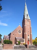
- St Leonards Catholic Church
- St Cuthberts Anglican Church (Naremburn Cammeray Anglican ChurchNaremburn Cammeray Anglican ChurchNaremburn Cammeray Anglican Church is a dynamic and growing Anglican Church on Sydney's North Shore. It is has four centres of Ministry - Naremburn, Cammeray, NAAC and SJEC.-History:...
)
Former primary schools
Until the 1990s, there were two primary schools operating — St Leonard’s Catholic Primary School, and, Naremburn Public School — both on Willoughby Road. The Catholic school shared the same site as the adjacent Catholic church, and, the public school was located opposite on Willoughby Road. Changing demographics and corresponding lack of demand lead to both schools being closed within five years of each other. The former Catholic school is now a creative arts learning centre. The former public school is now a housing development.External links
- Naremburn/St Leonards - community profile