
Nanda Devi National Park
Encyclopedia
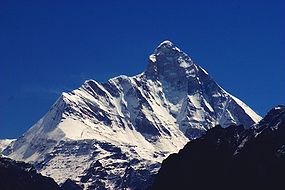
The Nanda Devi National Park is a national park
situated around the peak of Nanda Devi
, 7817 m (25,646 ft), in the state of Uttarakhand
in northern India
. It was established as national park in 1982. Along with the adjoining Valley of Flowers
National Park to the northwest, it was inscribed a World Heritage Site
by UNESCO
in 1988.. It covers 630.33 km² Both parks are encompassed in the Nanda Devi Biosphere Reserve (223,674 ha) which is further surrounded by a buffer zone (5,148.57 km²). This Reserve is in the UNESCO World Network of Biosphere Reserves
since 2004.
The park encompasses the Nanda Devi Sanctuary, a glacial basin surrounded by a ring of peaks between 6000 metres (19,685 ft) and 7500 m (24,606.3 ft) high, and drained by the Rishi Ganga through the Rishi Ganga Gorge, a steep, almost impassable defile
. The entire park lies at an elevation of more than 3500 m (11,482.9 ft) above mean sea level.
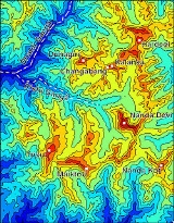
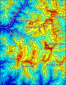 The Sanctuary can be divided into two parts, Inner and Outer. Together, they are surrounded by the main Sanctuary Wall, which forms a roughly square outline, with high, continuous ridges on the north, east, and south sides. On the west side, less high but still imposing ridges drop from the north and south toward the Rishi Ganga Gorge, which drains the Sanctuary towards the west.
The Inner Sanctuary occupies roughly the eastern two-thirds of the total area, and contains Nanda Devi itself and the two major glaciers flanking the peak, the Uttari (north) Rishi Glacier and the Dakkhni (south) Rishi Glacier. These are fed by the smaller Uttari Nanda Devi and Dakkhni Nanda Devi Glaciers respectively. The first recorded entry of humans into the Inner Sanctuary was by Eric Shipton
and H. W. Tilman
in 1934, via the Rishi Gorge.
The Outer Sanctuary occupies the western third of the total Sanctuary, and is separated from the Inner Sanctuary by high ridges, through which flows the Rishi Ganga. It is split in two by the Rishi Ganga; on the north side lies the Ramani Glacier, flowing down from the slopes of Dunagiri
and Changabang
, and on the south lies the Trisul Glacier, flowing from the peak of the same name. This portion of the Sanctuary is accessible to the outside (though requiring the crossing of a 4000 m (13,123.4 ft) pass). The first serious climbing expedition to pass through the Outer Sanctuary was that of T. G. Longstaff
, who climbed Trisul I
in 1907 via the eponymous glacier.
 Apart from Nanda Devi, the following peaks lie on ridges dividing the Inner and Outer Sanctuary areas.
, while others are independent peaks.
National park
A national park is a reserve of natural, semi-natural, or developed land that a sovereign state declares or owns. Although individual nations designate their own national parks differently A national park is a reserve of natural, semi-natural, or developed land that a sovereign state declares or...
situated around the peak of Nanda Devi
Nanda Devi
Nanda Devi is the second highest mountain in India and the highest entirely within the country ; owing to this geography it was the highest known mountain in the world until computations on Dhaulagiri by western surveyors in 1808...
, 7817 m (25,646 ft), in the state of Uttarakhand
Uttarakhand
Uttarakhand , formerly Uttaranchal, is a state in the northern part of India. It is often referred to as the Land of Gods due to the many holy Hindu temples and cities found throughout the state, some of which are among Hinduism's most spiritual and auspicious places of pilgrimage and worship...
in northern India
India
India , officially the Republic of India , is a country in South Asia. It is the seventh-largest country by geographical area, the second-most populous country with over 1.2 billion people, and the most populous democracy in the world...
. It was established as national park in 1982. Along with the adjoining Valley of Flowers
Valley of Flowers
Valley of Flowers National Park is an Indian national park, nestled high in West Himalaya, is renowned for its meadows of endemic alpine flowers and outstanding natural beauty. It is located in Uttarakhand state. This richly diverse area is also home to rare and endangered animals, including the...
National Park to the northwest, it was inscribed a World Heritage Site
World Heritage Site
A UNESCO World Heritage Site is a place that is listed by the UNESCO as of special cultural or physical significance...
by UNESCO
UNESCO
The United Nations Educational, Scientific and Cultural Organization is a specialized agency of the United Nations...
in 1988.. It covers 630.33 km² Both parks are encompassed in the Nanda Devi Biosphere Reserve (223,674 ha) which is further surrounded by a buffer zone (5,148.57 km²). This Reserve is in the UNESCO World Network of Biosphere Reserves
World Network of Biosphere Reserves
The UNESCO World Network of Biosphere Reserves covers internationally-designated protected areas, known as biosphere reserves, that are meant to demonstrate a balanced relationship between man and nature The UNESCO World Network of Biosphere Reserves covers internationally-designated protected...
since 2004.
The park encompasses the Nanda Devi Sanctuary, a glacial basin surrounded by a ring of peaks between 6000 metres (19,685 ft) and 7500 m (24,606.3 ft) high, and drained by the Rishi Ganga through the Rishi Ganga Gorge, a steep, almost impassable defile
Defile (geography)
Defile is a geographic term for a narrow pass or gorge between mountains or hills. It has its origins as a military description of a pass through which troops can march only in a narrow column or with a narrow front...
. The entire park lies at an elevation of more than 3500 m (11,482.9 ft) above mean sea level.
Layout of the Sanctuary
The Inner Sanctuary occupies roughly the eastern two-thirds of the total area, and contains Nanda Devi itself and the two major glaciers flanking the peak, the Uttari (north) Rishi Glacier and the Dakkhni (south) Rishi Glacier. These are fed by the smaller Uttari Nanda Devi and Dakkhni Nanda Devi Glaciers respectively. The first recorded entry of humans into the Inner Sanctuary was by Eric Shipton
Eric Shipton
Eric Earle Shipton CBE was a distinguished British Himalayan mountaineer.-Early years:Born in Ceylon in 1907 where his father, a tea planter, died before he was three years old. His mother buried her grief by taking Eric and his sister Marge and travelling constantly for the next five years...
and H. W. Tilman
Bill Tilman
Major Harold William "Bill" Tilman, CBE, DSO, MC and Bar was an English mountaineer and explorer, renowned for his Himalayan climbs and sailing voyages.-Early years and Africa:...
in 1934, via the Rishi Gorge.
The Outer Sanctuary occupies the western third of the total Sanctuary, and is separated from the Inner Sanctuary by high ridges, through which flows the Rishi Ganga. It is split in two by the Rishi Ganga; on the north side lies the Ramani Glacier, flowing down from the slopes of Dunagiri
Dunagiri (mountain)
Dunagiri is one of the high peaks of the Garhwal Himalayas in the northern Indian state of Uttarakhand. It lies at the northwest corner of the Sanctuary Wall, a ring of peaks surrounding Nanda Devi and enclosing the Nanda Devi Sanctuary....
and Changabang
Changabang
Changabang is a mountain in the Garhwal Himalaya of Uttarakhand, India. It is part of a group of peaks that form the northeast wall of the Nanda Devi Sanctuary. It is a particularly steep and rocky peak, and all routes on it are serious undertakings. It has been the site of many significant climbs...
, and on the south lies the Trisul Glacier, flowing from the peak of the same name. This portion of the Sanctuary is accessible to the outside (though requiring the crossing of a 4000 m (13,123.4 ft) pass). The first serious climbing expedition to pass through the Outer Sanctuary was that of T. G. Longstaff
Thomas George Longstaff
Tom George Longstaff was an English doctor, explorer and mountaineer, most famous for being the first person to climb a summit of over 7,000 meters in elevation, Trisul, in the Indian Himalaya in 1907. He also made important explorations and climbs in Tibet, Nepal, the Karakoram, Spitsbergen,...
, who climbed Trisul I
Trisul
Trisul is a group of three Himalayan mountain peaks of western Kumaun, with the highest reaching 7120m. The three peaks resemble a trident - in Hindi/Sanskrit, Trishul, trident, is the weapon of Shiva. The Trishul group forms the southeast corner of the ring of peaks enclosing the Nanda Devi...
in 1907 via the eponymous glacier.
Within the Sanctuary
- Nanda DeviNanda DeviNanda Devi is the second highest mountain in India and the highest entirely within the country ; owing to this geography it was the highest known mountain in the world until computations on Dhaulagiri by western surveyors in 1808...
: 7816 m (25,643 ft) - Devistan I, II: 6678 metres (21,909 ft), 6529 m (21,421 ft)
- Rishi Kot: 6236 m (20,459 ft)
On the Sanctuary Wall
These peaks are listed in clockwise order, starting from just north of the Rishi Gorge. Some of them are relatively minor summits and have small topographic prominenceTopographic prominence
In topography, prominence, also known as autonomous height, relative height, shoulder drop , or prime factor , categorizes the height of the mountain's or hill's summit by the elevation between it and the lowest contour line encircling it and no higher summit...
, while others are independent peaks.
- Hanuman: 6075 m (19,931 ft)
- DunagiriDunagiriDunagiri is a historic area in Almora district in the state of Uttarakhand in India at . Approximately from Delhi, a cluster of six small villages forms the place that is variously known as Dunagiri, Drongiri and Doonagiri. 116 such villages combine to form the Development Block of Dwarahat, which...
: 7066 m (23,182 ft) - ChangabangChangabangChangabang is a mountain in the Garhwal Himalaya of Uttarakhand, India. It is part of a group of peaks that form the northeast wall of the Nanda Devi Sanctuary. It is a particularly steep and rocky peak, and all routes on it are serious undertakings. It has been the site of many significant climbs...
: 6864 m (22,520 ft) - Kalanka: 6931 m (22,740 ft)
- Rishi PaharRishi PaharRishi Pahar is a Himalayan mountain peak, located in the Pithoragarh district of Uttarakhand state in India. It lies at the northeast corner of the ring of peaks surrounding the Nanda Devi Sanctuary, and on the eastern rim of the Nanda Devi Biosphere Reserve, just south of Trishuli and Hardeol. The...
: 6992 m (22,940 ft) - Mangraon: 6568 m (21,549 ft)
- Deo Damla: 6620 m (21,719 ft)
- Bamchu: 6303 m (20,679 ft)
- Sakram: 6254 m (20,518 ft)
- Latu Dhura: 6392 m (20,971 ft)
- Nanda Devi EastNanda DeviNanda Devi is the second highest mountain in India and the highest entirely within the country ; owing to this geography it was the highest known mountain in the world until computations on Dhaulagiri by western surveyors in 1808...
: 7434 m (24,390 ft) - Nanda Khat: 6611 m (21,690 ft)
- Panwali Doar (or "Panwali Dwar"): 6663 m (21,860 ft)
- Maiktoli: 6803 m (22,320 ft)
- Devtoli: 6788 m (22,270 ft)
- Mrigthuni: 6855 m (22,490 ft)
- TrisulTrisulTrisul is a group of three Himalayan mountain peaks of western Kumaun, with the highest reaching 7120m. The three peaks resemble a trident - in Hindi/Sanskrit, Trishul, trident, is the weapon of Shiva. The Trishul group forms the southeast corner of the ring of peaks enclosing the Nanda Devi...
I, II, III: 7120 metres (23,360 ft), 6690 metres (21,949 ft), 6008 m (19,711 ft) - Bethartoli Himal: 6352 m (20,840 ft)
Just outside the Wall
The following are the most notable peaks which are adjacent to the wall; they are all connected to the Wall by high passes. They lie just outside the boundaries of the Park.- HardeolHardeolHardeol or 'Temple of God' is one of the major peaks of the Kumaon Himalaya. It is the highest peak on the northern side of the ring of peaks guarding the Nanda Devi Sanctuary, and lies at the northeast corner of this ring. It is situated at the northern end of the Milam valley, in the Pithoragarh...
: 7151 m (23,461 ft) (northeast corner) - TrishuliTrishuliTirsuli is a Himalayan mountain peak in the Pithoragarh district of Kumaon Uttarakhand, India. It is part of the complex of mountains, including Tirsuli West, Hardeol, Dunagiri, Changabang, and Kalanka, which make up the northeast wall of the Nanda Devi Sanctuary, in the Garhwal Himalaya. It rises...
: 7074 m (23,209 ft) (just beyond Hardeol) - Nanda KotNanda KotNanda Kot is a mountain peak of the Himalaya range located in the Pithoragarh district of Uttarakhand state in India. It lies in the Kumaon Himalaya, just outside of the ring of peaks enclosing the Nanda Devi Sanctuary, southeast of Nanda Devi itself...
: 6861 m (22,510 ft) (southeast corner) - Nanda GhuntiNanda GhuntiNanda Ghunti is a 6,309 metre high mountain in Garhwal, IndiaIt lies on the Outer Rim of the Nanda Devi Sanctuary. It was first surveyed by TG Longstaff in 1907. Eric Shipton surveyed it from West in 1931. First serious attempt was made by BP Goodfellow J Buz , in 1944...
: 6309 m (20,699 ft) (southwest corner)