
Namcha Barwa
Encyclopedia
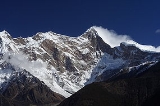
Namjagbarwa Peak also known as Namcha Barwa, Namchabarwa, or Nanjiabawa Feng, is a mountain
in the Tibet
an Himalaya. The traditional definition of the Himalaya extending from the Indus River to the Brahmaputra would make it the eastern anchor of the entire mountain chain, and it is the highest peak of its own section
as well Earth's easternmost peak over 7,600 metres.
, emerging as the Dihang and becoming the Brahmaputra. Namjagbarwa's sister peak Gyala Peri
7,294 metres rises across the gorge 22 km to the NNW.
in the Karakoram
was climbed in 1976, Namcha Barwa became the highest unclimbed independent mountain
in the world., until it was finally climbed in 1992.
Frank Kingdon-Ward may have presaged the effects of global warming some 85 years ago when describing "a quaint prophecy among the Kongbo Tibetans that Namche Barwa will one day fall into the Tsangpo gorge and block the river, which will then turn aside and flow over the Doshong La [pass]. This is recorded in a book by some fabulous person whose image may be seen in the little gompa [monastery] at Payi, in Pome. " (126-7)
U.K. Alpine Club's Himalayan Index lists no further ascents.
Mountain
Image:Himalaya_annotated.jpg|thumb|right|The Himalayan mountain range with Mount Everestrect 58 14 160 49 Chomo Lonzorect 200 28 335 52 Makalurect 378 24 566 45 Mount Everestrect 188 581 920 656 Tibetan Plateaurect 250 406 340 427 Rong River...
in the Tibet
Tibet
Tibet is a plateau region in Asia, north-east of the Himalayas. It is the traditional homeland of the Tibetan people as well as some other ethnic groups such as Monpas, Qiang, and Lhobas, and is now also inhabited by considerable numbers of Han and Hui people...
an Himalaya. The traditional definition of the Himalaya extending from the Indus River to the Brahmaputra would make it the eastern anchor of the entire mountain chain, and it is the highest peak of its own section
Namcha Barwa Himal
Namcha Barwa Himal, also known as Namjagbarwa syntaxis or Namjagbarwa Group Complex, is the easternmost section of the Himalaya in southeastern Tibet and northeastern India. This section spans 180 km...
as well Earth's easternmost peak over 7,600 metres.
Location
Namjagbarwa is in an isolated part of southeastern Tibet rarely visited by outsiders. It stands inside the Great Bend of the Yarlung Tsangpo River as the river enters its notable gorge across the HimalayaHimalayas
The Himalaya Range or Himalaya Mountains Sanskrit: Devanagari: हिमालय, literally "abode of snow"), usually called the Himalayas or Himalaya for short, is a mountain range in Asia, separating the Indian subcontinent from the Tibetan Plateau...
, emerging as the Dihang and becoming the Brahmaputra. Namjagbarwa's sister peak Gyala Peri
Gyala Peri
Gyala Peri is a peak just beyond the eastern end of the Himalaya at the entrance to Tsangpo gorge. Its height is sometimes listed as 7150 m....
7,294 metres rises across the gorge 22 km to the NNW.
Notable features
Namcha rises 5,000 to 6,800 metres above the Yarlung Tsangpo. After 7,795 metre Batura SarBatura Sar
Batura Sar, also referred to as Batura I, is the 25th highest mountain on earth and the 10th highest in Pakistan. It is the highest peak of the Batura Muztagh, which is the westernmost subrange of the Karakoram range...
in the Karakoram
Karakoram
The Karakoram, or Karakorum , is a large mountain range spanning the borders between Pakistan, India and China, located in the regions of Gilgit-Baltistan , Ladakh , and Xinjiang region,...
was climbed in 1976, Namcha Barwa became the highest unclimbed independent mountain
Highest unclimbed mountain
The highest unclimbed mountain in a particular region or in the world is often a matter of controversy. In some parts of the world surveying and mapping are still not reliable, and there are not comprehensive records of the routes of explorers, mountaineers and local inhabitants.However, a major...
in the world., until it was finally climbed in 1992.
Frank Kingdon-Ward may have presaged the effects of global warming some 85 years ago when describing "a quaint prophecy among the Kongbo Tibetans that Namche Barwa will one day fall into the Tsangpo gorge and block the river, which will then turn aside and flow over the Doshong La [pass]. This is recorded in a book by some fabulous person whose image may be seen in the little gompa [monastery] at Payi, in Pome. " (126-7)
Climbing history
Namcha Barwa was located in 1912 by British surveyors but the area remained virtually unvisited until Chinese alpinists began attempting the peak in the 1980s. Although they scouted multiple routes, they did not reach the summit. In 1990 a Japanese-Chinese expedition reconnoitered the peak. Another joint expedition reached 7460m in 1991 but lost member Hiroshi Onishi in an avalanche. The next year a third Japanese-Chinese expedition established six camps on the South Ridge over intermediate Nai Peng (7,043m) reaching the summit October 30.U.K. Alpine Club's Himalayan Index lists no further ascents.
External links
- Chinese expedition in the 1980s