

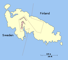
Märket
Encyclopedia
Skerry
A skerry is a small rocky island, usually defined to be too small for habitation. It may simply be a rocky reef. A skerry can also be called a low sea stack....
in the Baltic Sea
Baltic Sea
The Baltic Sea is a brackish mediterranean sea located in Northern Europe, from 53°N to 66°N latitude and from 20°E to 26°E longitude. It is bounded by the Scandinavian Peninsula, the mainland of Europe, and the Danish islands. It drains into the Kattegat by way of the Øresund, the Great Belt and...
between Sweden
Sweden
Sweden , officially the Kingdom of Sweden , is a Nordic country on the Scandinavian Peninsula in Northern Europe. Sweden borders with Norway and Finland and is connected to Denmark by a bridge-tunnel across the Öresund....
and Finland
Finland
Finland , officially the Republic of Finland, is a Nordic country situated in the Fennoscandian region of Northern Europe. It is bordered by Sweden in the west, Norway in the north and Russia in the east, while Estonia lies to its south across the Gulf of Finland.Around 5.4 million people reside...
(in the area of the autonomous Åland Islands
Åland Islands
The Åland Islands form an archipelago in the Baltic Sea. They are situated at the entrance to the Gulf of Bothnia and form an autonomous, demilitarised, monolingually Swedish-speaking region of Finland...
), which has been divided between two sovereignties since the Treaty of Fredrikshamn of 1809 defined the border between Sweden and Russian Empire
Russian Empire
The Russian Empire was a state that existed from 1721 until the Russian Revolution of 1917. It was the successor to the Tsardom of Russia and the predecessor of the Soviet Union...
as going through the middle of the island. The westernmost land point of Finland is on Märket. The Finnish side of the island is part of the Municipality of Hammarland
Hammarland
Hammarland is a municipality of Åland, an autonomous territory of Finland.The municipality has a population of and covers an area of ofwhich is water. The population density is.The municipality is unilingually Swedish...
.. The Swedish part of island is itself divided by two counties of Sweden
Counties of Sweden
The Counties of Sweden are the first level administrative and political subdivisions of Sweden. Sweden is divided into 21 counties. The counties were established in 1634 on Count Axel Oxenstierna's initiative, superseding the historical provinces of Sweden to introduce a modern administration...
- Uppsala County
Uppsala County
Uppsala County is a county or län on the eastern coast of Sweden. It borders the counties of Stockholm, Södermanland, Västmanland, Gävleborg, and the Baltic Sea.- Province :For History, Geography and Culture see: Uppland...
(Östhammar Municipality
Östhammar Municipality
Östhammar Municipality is a municipality in Uppsala County in east central Sweden. Its seat is located in the city of Östhammar....
) and Stockholm County
Stockholm County
Stockholm County is a county or län on the Baltic sea coast of Sweden. It borders Uppsala County and Södermanland County. It also borders Mälaren and the Baltic Sea. The city of Stockholm is the capital of Sweden. Stockholm County is divided by the historic provinces of Uppland and Södermanland...
(Norrtälje Municipality
Norrtälje Municipality
Norrtälje Municipality is a municipality in Stockholm County in east central Sweden. Its seat is located in the city of Norrtälje....
).
Geography and history
The 6 NM wide UnderstenUndersten
Understen is a Swedish island and lighthouse station located in South Kvarken, east of Öregrund at the northern tip of sea of Åland in Sweden. The first day beacon on the island was built in the 18th century. The first lighthouse was built in 1848, and lit in November that year with a colza oil lamp...
–Märket Passage links the Bothnian Sea
Bothnian Sea
The Bothnian Sea links the Bothnian Bay with the Baltic proper. Kvarken is situated between the two. Together, the Bothnian Sea and Bay make up a larger geographical entity, the Gulf of Bothnia...
to the Baltic proper
Baltic Sea
The Baltic Sea is a brackish mediterranean sea located in Northern Europe, from 53°N to 66°N latitude and from 20°E to 26°E longitude. It is bounded by the Scandinavian Peninsula, the mainland of Europe, and the Danish islands. It drains into the Kattegat by way of the Øresund, the Great Belt and...
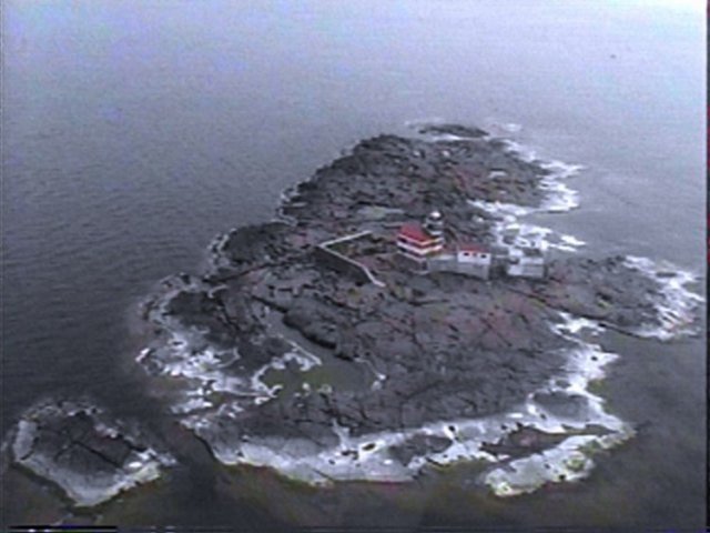
. The skerry is roughly 350 metres (1,148.3 ft) long by 150 metres (492.1 ft) wide, and its area is about 3.3 hectares (8.2 acre). It is argued to be the smallest sea island shared by two countries.
The name Märket ('the Mark') probably comes from its usefulness as a navigation mark before there were lighthouses. The route between Sweden and Åland has a passage of about 27 kilometres (27,000,000,000,000 nm) (17 mi) length over open sea, and it was probably good to have a mark to aim at.
There is a lighthouse
Lighthouse
A lighthouse is a tower, building, or other type of structure designed to emit light from a system of lamps and lenses or, in older times, from a fire, and used as an aid to navigation for maritime pilots at sea or on inland waterways....
on the Finnish side of the current border, which has been unmanned and automated since 1979. When it was built by the Russians and Finns in 1885 there were no clear maps of the island. After the completion of the lighthouse, it was discovered that it had been built on the Swedish part of the island.
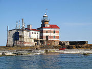
This dilemma resulted in an unusual shape for the international border, one that ingeniously satisfied both Finnish and Swedish interests. The adjusted border takes the form of an inverted 'S', and the lighthouse is connected to the rest of Finland only by a short stretch of land. The border is regularly resurveyed every 25 years by officials representing both countries. The last such joint inspection took place in August 2006.
The lighthouse is in urgent need of maintenance, and a Finnish interest group is trying to raise funds for its preservation. The lighthouse has been automatic since 1979 and the surrounding buildings are no longer used. The increasing general availability of GPS has made its primary function redundant.
Radio amateurs activity
Radio amateursAmateur radio operator
An amateur radio operator is an individual who typically uses equipment at an amateur radio station to engage in two-way personal communications with other similar individuals on radio frequencies assigned to the amateur radio service. Amateur radio operators have been granted an amateur radio...
and CB
Citizens' band radio
Citizens' Band radio is, in many countries, a system of short-distance radio communications between individuals on a selection of 40 channels within the 27-MHz band. Citizens' Band is distinct from the FRS, GMRS, MURS and amateur radio...
operators around the world consider the Finnish part of Market Reef (as they call it) a separate entity, distinct from Finland and Sweden. The Finnish part of Market Reef used to be one of the world's most desired "countries"
DX Century Club
The DX Century Club, or DXCC, is an amateur radio operating award earned by making contact with 100 or more geographic entities around the world....
among radio amateurs due to its special status and relative remoteness. Usually there are one or more Amateur Radio expeditions to the island every year, weather permitting. During these expeditions tens of thousands of radio contacts are made with people in several parts of the world. At high seas, landing is only possible with a helicopter. Good pictures of Märket are shown on QSL
QSL
QSL is one of the Q codes used in radiocommunication and radio broadcasting. A Q code message can stand for a statement or a question . In this case, QSL? means "do you confirm receipt of my transmission?" while QSL means "I confirm receipt of your transmission". Some also take it to mean "Query...
cards. The official prefix for use on the Finnish side is OH0, as in the rest of the Åland Islands, but OJ0 is the optional call sign
Call sign
In broadcasting and radio communications, a call sign is a unique designation for a transmitting station. In North America they are used as names for broadcasting stations...
prefix
ITU prefix
The International Telecommunication Union allocates call sign prefixes for radio and television stations of all types. They also form the basis for, but do not exactly match, aircraft registration identifiers. These prefixes are agreed upon internationally, and are a form of country code...
for Market Reef. There is a fee for using an OJ0 call sign, while the use of the OH0/ prefix in front of the own call sign is free. All radio activity on the island is by visitors on DX-pedition
DX-pedition
A DX-pedition is an expedition to what is considered an exotic place by amateur radio operators, perhaps because of its remoteness or because there are very few radio amateurs active from that place. This could be an island, a country, or even a particular spot on a geographical grid.The activity...
s. When the Finnish part of the reef was given its special status in amateur radio, in the late 1960s the lighthouse keeper himself became a licenced Amateur Radio operator who initially used the call OH0MA. On the Swedish side of Market Reef the callsigns 8S9M and SI8MI have been used.
Climate
Märket has a continental climate affected by oceanic influences; it has a reputation for being one of the windiest places in FinlandFinland
Finland , officially the Republic of Finland, is a Nordic country situated in the Fennoscandian region of Northern Europe. It is bordered by Sweden in the west, Norway in the north and Russia in the east, while Estonia lies to its south across the Gulf of Finland.Around 5.4 million people reside...
. A meteorological station has been managed by the lighthouse keepers since 1896 and an automatic station was inaugurated on the November 10, 1977 a short while after its automation.
The effect of the sea is very important to the climate of the island: thermal inertia dramatically reduces the temperature fluctuations during the year compared to the continent and to a lesser extent compared to the central part of Fasta Åland
Fasta Åland
Fasta Åland is the largest and most populous island of Åland, an autonomous province of Finland. The provincial capital Mariehamn is located on the island. With the area of 685 km² it is the 3rd largest island in Finland....
, the largest island of the archipelago of Åland. Märket holds five records for daytime temperatures for weather stations in Finland, all in the period between November 29 and January 1, with 10.2°C (50.4°F) on December 15, 2006 and 8.8°C (47.8°F) on December 31, 1975. The average yearly temperature is roughly 6°C (43°F) and is one of the in highest in Finland, with the month of January being milder than on the continent (-2.5°C or 28°F on average), and a warm summer (15.9°C or 61°F on average in July). The island is drier than the mainland: the average rainfall does not usually surpass 550mm (21.7 in).
External links
- 2007 Radio DXpedition to Märket
- Configurable map centred on Märket from Citizen's Mapsite of Finland
- The Swedish Lighthouse Society's site on Märket
- Market Reef at MostTraveledPeople.com
- Joint border survey between Finland and Sweden in progress from Helsingin SanomatHelsingin SanomatHelsingin Sanomat is the largest subscription newspaper in Finland and the Nordic countries, owned by Sanoma. Except after certain holidays, it is published daily. In 2008, its daily circulation was 412,421 on weekdays and 468,505 on Sundays...
(International Edition), includes paragraph about Märket, with a small map. - A recent air photo of the island