

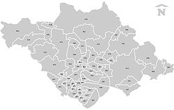
Municipalities of Tlaxcala
Encyclopedia

Mexico
The United Mexican States , commonly known as Mexico , is a federal constitutional republic in North America. It is bordered on the north by the United States; on the south and west by the Pacific Ocean; on the southeast by Guatemala, Belize, and the Caribbean Sea; and on the east by the Gulf of...
state
States of Mexico
The United Mexican States is a federal republic formed by 32 federal entities .According to the Constitution of 1917, the states of the federation are free and sovereign. Each state has their own congress and constitution, while the Federal District has only limited autonomy with a local Congress...
of Tlaxcala
Tlaxcala
Tlaxcala officially Estado Libre y Soberano de Tlaxcala is one of the 31 states which along with the Federal District comprise the 32 federative entities of Mexico. It is divided into 60 municipalities and its capital city is Tlaxcala....
is made up of 60 municipalities (municipios
Municipality
A municipality is essentially an urban administrative division having corporate status and usually powers of self-government. It can also be used to mean the governing body of a municipality. A municipality is a general-purpose administrative subdivision, as opposed to a special-purpose district...
).
|- style="text-align:center; background:#d8edff;"
!INEGI
National Institute of Statistics, Geography, and Data Processing
The National Institute of Statistic and Geography is an autonomous agency of the Mexican Government dedicated to coordinate the National System of Statistical and Geographical Information of the country...
code!!Municipality!!Municipal Seat
|-
| 001 || Acuamanala de Miguel Hidalgo
Acuamanala de Miguel Hidalgo
Acuamanala de Miguel Hidalgo is a municipality in Tlaxcala in south-eastern Mexico.-References:...
|| Acuamanala
|-
| 002 || Altzayanca || Atlzayanca
|-
| 003 || Amaxac de Guerrero || Amaxac de Guerrero
|-
| 004 || Apetatitlán de Antonio Carvajal
Apetatitlán de Antonio Carvajal
Apetatitlán de Antonio Carvajal is a municipality in Tlaxcala in south-eastern Mexico.-References:...
|| Apetatitlán
|-
| 005 || Apizaco
Apizaco
Apizaco is a city in Apizaco Municipality located near the geographic center of the Mexican state of Tlaxcala, approximately 25 minutes by car from the state's capital city of Tlaxcala. The city gets its name from the Nahuatl language words "ātl" , "pitzāhuac" , and the suffix "co" , forming...
|| Apizaco
Apizaco
Apizaco is a city in Apizaco Municipality located near the geographic center of the Mexican state of Tlaxcala, approximately 25 minutes by car from the state's capital city of Tlaxcala. The city gets its name from the Nahuatl language words "ātl" , "pitzāhuac" , and the suffix "co" , forming...
|-
| 006 || Atlangatepec || Atlangatepec
|-
| 007 || Benito Juárez || Benito Juárez
|-
| 008 || Calpulalpan || Calpulalpan
|-
| 009 || Chiautempan || Santa Ana Chiautempan
|-
| 010 || Contla de Juan Cuamatzi
Contla de Juan Cuamatzi
Contla de Juan Cuamatzi is a municipality in Tlaxcala in south-eastern Mexico.-References:...
|| Contla
Contla
Contla consists of two nearby villages in Tlaxcala, Mexico.One village is also called San Bernardino Contla or simply San Bernardino, and is located at...
|-
| 011 || Cuapiaxtla || Cuapiaxtla
|-
| 012 || Cuaxomulco || Cuaxomulco
|-
| 013 || El Carmen Tequexquitla
El Carmen Tequexquitla
El Carmen Tequexquitla is a municipality in Tlaxcala in south-eastern Mexico.-References:...
|| Tequixquitla
|-
| 014 || Emiliano Zapata || Emiliano Zapata
|-
| 015 || Españita || Españita
|-
| 016 || Huamantla
Huamantla
Huamantla is a city and its surrounding municipality of the same name, located in the eastern part of the Mexican state of Tlaxcala. It is the third-largest city in the state in population , with a 2005 census population of 47,286...
|| Huamantla
|-
| 017 || Hueyotlipan || Hueyotlipan
|-
| 018 || Ixtacuixtla de Mariano Matamoros
Ixtacuixtla de Mariano Matamoros
Ixtacuixtla de Mariano Matamoros is a municipality in Tlaxcala in south-eastern Mexico....
|| Villa Mariano Matamoros
|-
| 019 || Ixtenco || Ixtenco
|-
| 020 || La Magdalena Tlaltelulco || La Magdalena Tlaltelulco
|-
| 021 || Lázaro Cárdenas || Lázaro Cárdenas
|-
| 022 || Mazatecochco de José María Morelos
Mazatecochco de José María Morelos
Mazatecochco de José María Morelos is a municipality in Tlaxcala in south-eastern Mexico.-References:...
|| Mazatecochco
|-
| 023 || Muñoz de Domingo Arenas
Muñoz de Domingo Arenas
Muñoz de Domingo Arenas is a municipality in Tlaxcala in south-eastern Mexico.-References:...
|| Muñoz
|-
| 024 || Nanacamilpa de Mariano Arista
Nanacamilpa de Mariano Arista
Nanacamilpa de Mariano Arista is a municipality in Tlaxcala in south-eastern Mexico.-References:...
|| Nanacamilpa
|-
| 025 || Nativitas || Nativitas
|-
| 026 || Panotla || Panotla
|-
| 027 || Papalotla de Xicohtencatl
Papalotla de Xicohténcatl
Papalotla de Xicohténcatl is a municipality in Tlaxcala in south-eastern Mexico.-References:...
|| Papalotla
Papalotla
Papalotla is a small town and municipality in Mexico State in Mexico. The municipality covers an area of .As of 2005, the municipality had a total population of 3766....
|-
| 028 || Sanctorum de Lázaro Cárdenas
Sanctorum de Lázaro Cárdenas
Sanctorum de Lázaro Cárdenas is a municipality in Tlaxcala in south-eastern Mexico....
|| Sanctorum
|-
| 029 || San Damián Texoloc || San Damián Texoloc
|-
| 030 || San Francisco Tetlanohcan
San Francisco Tetlanohcan
San Francisco Tetlanohcan is a town in the Mexican state of Tlaxcala, at the foot of the La Malinche dormant volcano. San Francisco Tetlanohcan has a population of 10,000 inhabitants, and is located about 20 minutes east of the state capital, Tlaxcala, Tlaxcala.-External...
|| San Francisco Tetlanohcan
San Francisco Tetlanohcan
San Francisco Tetlanohcan is a town in the Mexican state of Tlaxcala, at the foot of the La Malinche dormant volcano. San Francisco Tetlanohcan has a population of 10,000 inhabitants, and is located about 20 minutes east of the state capital, Tlaxcala, Tlaxcala.-External...
|-
| 031 || San Jerónimo Zacualpan || San Jerónimo Zacualpan
|-
| 032 || San José Teacalco || San José Teacalco
|-
| 033 || San Juan Huactzinco || San Juan Huactzinco
|-
| 034 || San Lorenzo Axocomanitla || Lorenzo Axocomanitla]
|-
| 035 || San Lucas Tecopilco || San Lucas Tecopilco
|-
| 036 || San Pablo del Monte
San Pablo del Monte
San Pablo del Monte is a municipality in Tlaxcala in south-eastern Mexico.-References:...
|| Villa Vicente Guerrero
|-
| 037 || Santa Ana Nopalucan || Santa Ana Nopalucan
|-
| 038 || Santa Apolonia Teacalco || Santa Apolonia Teacalco
|-
| 039 || Santa Catarina Ayometla || Santa Catarina Ayometla
|-
| 040 || Santa Cruz Quilehtla || Santa Cruz Quilehtla
|-
| 041 || Santa Cruz Tlaxcala || Santa Cruz Tlaxcala
|-
| 042 || Santa Isabel Xiloxoxtla || Santa Isabel Xiloxoxtla
|-
| 043 || Tenancingo || Tenancingo
|-
| 044 || Teolocholco || Teolocholco
|-
| 045 || Tepetitla de Lardizabal || Tepetitla
|-
| 046 || Tepeyanco || Tepeyanco
|-
| 047 || Terrenate
Terrenate, Tlaxcala
Terrenate is a city, and the surrounding municipality of the same name, in the Mexican state of Tlaxcala.It is situated in the highest part of the state, at 2,680 metres above sea level...
|| San Nicolás Terrenate
|-
| 048 || Tetla de la Solidaridad
Tetla de la Solidaridad
Tetla de la Solidaridad is a municipality in Tlaxcala in south-eastern Mexico.-References:...
|| Tetla
Tetla
-Location:National Highway 200 passes through Tetla. It is about 12 km south of Raigarh. The nearest airport is Raipur Airport, and the nearest railway station is at Raigarh....
|-
| 049 || Tetlatlahuca || Tetlatlahuca
|-
| 050 || Tlaxcala
Tlaxcala, Tlaxcala
The city of Tlaxcala is the capital and chief center of population of the Mexican state of Tlaxcala. The city is located at in the south-central portion of the state. In the census of 2005 the city had a population of 15,777 inhabitants and was by far the smallest state capital in Mexico. It is...
|| Tlaxcala
Tlaxcala, Tlaxcala
The city of Tlaxcala is the capital and chief center of population of the Mexican state of Tlaxcala. The city is located at in the south-central portion of the state. In the census of 2005 the city had a population of 15,777 inhabitants and was by far the smallest state capital in Mexico. It is...
|-
| 051 || Tlaxco || Tlaxco
|-
| 052 || Tocatlán || Tocatlán
|-
| 053 || Totolac
Totolac
Totolac is a municipality in Tlaxcala in south-eastern Mexico.-References:...
|| San Juan Totolac
|-
| 054 || Tzompantepec || Tzompantepec
|-
| 055 || Xaloztoc || Xaloztoc
|-
| 056 || Xaltocan
Xaltocan, Tlaxcala
Xaltocan is in Xaltocan Municipality in the Mexican state of Tlaxcala.The name can mean either of two things in the Nahuatl language: either 'sandy ground of spiders' or 'where sand sowing'...
|| Xaltocan
|-
| 057 || Xicohtzinco || Xicohtzinco
|-
| 058 || Yauhquemecan || Yauhquemehcan
|-
| 059 || Zacatelco || Zacatelco
|-
| 060 || Zitlaltepec de Trinidad Sánchez Santos
Zitlaltepec de Trinidad Sánchez Santos
Zitlaltepec de Trinidad Sánchez Santos is a municipality in Tlaxcala in south-eastern Mexico.-References:...
|| Zitlaltepec
|}