

Municipalities of Tabasco
Encyclopedia
Mexico
The United Mexican States , commonly known as Mexico , is a federal constitutional republic in North America. It is bordered on the north by the United States; on the south and west by the Pacific Ocean; on the southeast by Guatemala, Belize, and the Caribbean Sea; and on the east by the Gulf of...
state
States of Mexico
The United Mexican States is a federal republic formed by 32 federal entities .According to the Constitution of 1917, the states of the federation are free and sovereign. Each state has their own congress and constitution, while the Federal District has only limited autonomy with a local Congress...
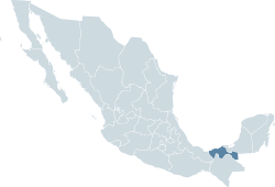
of Tabasco
Tabasco
Tabasco officially Estado Libre y Soberano de Tabasco is one of the 31 states which, with the Federal District, comprise the 32 Federal Entities of Mexico. It is divided in 17 municipalities and its capital city is Villahermosa....
is made up of 17 municipalities (municipios).
|- align=center style="background:#d8edff"
! INEGI
National Institute of Statistics, Geography, and Data Processing
The National Institute of Statistic and Geography is an autonomous agency of the Mexican Government dedicated to coordinate the National System of Statistical and Geographical Information of the country...
code
! Municipality
! Municipal Seat
|-
| 001 || Balancán || Balancán
|-
| 002 || Cárdenas || Cárdenas
Cárdenas, Tabasco
Cárdenas is the second-largest city in the state of Tabasco, in southeastern Mexico. It lies in the northwestern part of the state, on the Gulf of Mexico coast, east of the city of Coatzacoalcos, Veracruz. The city is the municipal seat of Cárdenas Municipality. At the census of 2005 the city had a...
|-
| 003 || Centla || Frontera
|-
| 004 || Centro || Villahermosa
Villahermosa
Like most of the Tabasco, Villahermosa has a tropical climate. The city specifically features a tropical monsoon climate. Temperatures during spring and summer seasons reach upwards of 40°C , with humidity levels hovering around 30% during the same period...
|-
| 005 || Comalcalco || Comalcalco
Comalcalco
Comalcalco is both a modern-day city located in Comalcalco Municipality about 45 miles northwest of Villahermosa in the Mexican state of Tabasco and a Pre-Columbian Maya archaeological site. The literal English translation of "Comalcalco" is "In the house of the comals"...
|-
| 006 || Cunduacán || Cunduacán
Cunduacán
Cunduacán is a municipality in the central portion of the state of Tabasco, in Mexico. It is located at about 18°4'0"North, 93°10'0"West.It is located in the Grijalva River Region, Chontalpa subregion. Its name originates from the Mayan cum-ua-cán, which means "place of corn and serpents", which is...
|-
| 007 || Emiliano Zapata || Emiliano Zapata
|-
| 008 || Huimanguillo
Huimanguillo (municipality)
Huimanguillo is a municipality in Tabasco in south-eastern Mexico.-References:...
|| Huimanguillo
|-
| 009 || Jalapa
Jalapa (municipality)
Jalapa is a municipality in Tabasco in south-eastern Mexico.-References:...
|| Jalapa
Jalapa, Tabasco
Jalapa is a small city in the Mexican state of Tabasco. It is located at .Jalapa also serves as the administrative centre for the surrounding municipality of the same name, which covers a total surface area of 642.91 km² and, in the year 2000 census, reported a population of 32,773.-External...
|-
| 010 || Jalpa de Méndez
Jalpa de Méndez (municipality)
Jalpa de Méndez is a municipality in Tabasco in south-eastern Mexico.-References:...
|| Jalpa de Méndez
|-
| 011 || Jonuta
Jonuta (municipality)
Jonuta is a municipality in Tabasco in south-eastern Mexico.-References:...
|| Jonuta
|-
| 012 || Macuspana
Macuspana
Macuspana is a city in Macuspana Municipality in the south-central part of the state of Tabasco in southeastern Mexico. The city of Macuspana had a 2005 census population of 30,661 and is the fifth-largest city in the state...
|| Macuspana
Macuspana
Macuspana is a city in Macuspana Municipality in the south-central part of the state of Tabasco in southeastern Mexico. The city of Macuspana had a 2005 census population of 30,661 and is the fifth-largest city in the state...
|-
| 013 || Nacajuca
Nacajuca (municipality)
Nacajuca is a municipality in Tabasco in south-eastern Mexico.-References:...
|| Nacajuca
|-
| 014 || Paraíso
Paraíso (municipality)
Paraíso is a municipality in Tabasco in south-eastern Mexico.-References:...
|| Paraíso
Paraíso, Tabasco
Paraíso is a town in the Mexican state of Tabasco. It is located near the Grijalva River in the subregion of Chontalpa.Paraíso is 577.55 km², which corresponds to 1.5% of the entire country. It is the seventeenth largest territory in Mexico...
|-
| 015 || Tacotalpa
Tacotalpa (municipality)
Tacotalpa is a municipality in Tabasco in south-eastern Mexico.-References:...
|| Tacotalpa
|-
| 016 || Teapa || Teapa
|-
| 017 || Tenosique
Tenosique
Tenosique is a town located in Tenosique Municipality in the southeastern corner of the state of Tabasco, in Mexico. Its official name is Tenosique de Pino Suárez. The town had a 2005 census population of 31,392 inhabitants , while the municipality had a population of 55,601...
|| Tenosique de Pino Suárez
|}