
Mulberry Fork of the Black Warrior River
Encyclopedia
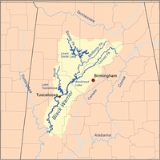
Mulberry Fork is a tributary of the Black Warrior River
, 102 miles (164.2 km) long, in the U.S.
state of Alabama
. The Mulberry Fork is one of three forks, along with the Locust Fork
and the Sipsey Fork
, that join to form the Black Warrior. It drains part of the southernmost end of the Appalachian Mountains
north and west of Birmingham
in the drainage basin
of the Mobile River
.
The Mulberry Fork rises in northeastern Cullman County
, south of Arab
. It flows in tight meander
s along a ridge of the foothills, forming the boundary between Cullman and Blount
counties. It receives the Sipsey Fork from the northwest approximately 15 mi (24 km) east of Jasper
. In southern Walker County
it enters Bankhead Lake
reservoir, forming the northernmost arm of the lake, approximately 10 mi (16 km) long. The confluence with the Locust Fork is now submerged within Bankhead Lake, approximately 25 mi (40 km) west of Birmingham.
Black Warrior River
The Black Warrior River is a waterway in west central Alabama in the southeastern United States. The river rises in the extreme southern edges of the Appalachian Highlands and flows 178 miles to the Tombigbee River, of which the Black Warrior is the primary tributary...
, 102 miles (164.2 km) long, in the U.S.
United States
The United States of America is a federal constitutional republic comprising fifty states and a federal district...
state of Alabama
Alabama
Alabama is a state located in the southeastern region of the United States. It is bordered by Tennessee to the north, Georgia to the east, Florida and the Gulf of Mexico to the south, and Mississippi to the west. Alabama ranks 30th in total land area and ranks second in the size of its inland...
. The Mulberry Fork is one of three forks, along with the Locust Fork
Locust Fork of the Black Warrior River
The Locust Fork, in Blount, Etowah, and Marshall counties is one of three major tributaries of the Black Warrior River. The river features several stretches of whitewater, and is popular with canoers and kayakers. In the late 1980s, the Birmingham Water Works proposed damming the river as a...
and the Sipsey Fork
Sipsey Fork of the Black Warrior River
The Sipsey Fork of the Black Warrior River is a river located in Alabama, USA, and is formed by the junction of Thompson and Hubbard creeks in the Sipsey Wilderness of Bankhead National Forest. The Sipsey Fork discharges into the Mulberry Fork. The Sipsey Fork below Smith Lake is one of the few...
, that join to form the Black Warrior. It drains part of the southernmost end of the Appalachian Mountains
Appalachian Mountains
The Appalachian Mountains #Whether the stressed vowel is or ,#Whether the "ch" is pronounced as a fricative or an affricate , and#Whether the final vowel is the monophthong or the diphthong .), often called the Appalachians, are a system of mountains in eastern North America. The Appalachians...
north and west of Birmingham
Birmingham, Alabama
Birmingham is the largest city in Alabama. The city is the county seat of Jefferson County. According to the 2010 United States Census, Birmingham had a population of 212,237. The Birmingham-Hoover Metropolitan Area, in estimate by the U.S...
in the drainage basin
Drainage basin
A drainage basin is an extent or an area of land where surface water from rain and melting snow or ice converges to a single point, usually the exit of the basin, where the waters join another waterbody, such as a river, lake, reservoir, estuary, wetland, sea, or ocean...
of the Mobile River
Mobile River
The Mobile River is located in southern Alabama in the United States. Formed out of the confluence of the Tombigbee and Alabama rivers, the approximately river drains an area of of Alabama, with a watershed extending into Mississippi, Georgia, and Tennessee. Its drainage basin is the...
.
The Mulberry Fork rises in northeastern Cullman County
Cullman County, Alabama
Cullman County is a county of the U.S. state of Alabama. Its name is in honor of Colonel John G. Cullmann. As of 2010, the population was 80,406. Its county seat is the town of the same name, Cullman, Alabama. It is a "moist" county in terms of availablity of alcoholic beverages, which means...
, south of Arab
Arab, Alabama
Arab is a city in both Cullman County, Alabama and Marshall County, Alabama in the northeastern part of the U.S. state of Alabama, located ten miles from Guntersville Lake and Guntersville Dam, and is included in the Huntsville-Decatur Combined Statistical Area...
. It flows in tight meander
Meander
A meander in general is a bend in a sinuous watercourse. A meander is formed when the moving water in a stream erodes the outer banks and widens its valley. A stream of any volume may assume a meandering course, alternately eroding sediments from the outside of a bend and depositing them on the...
s along a ridge of the foothills, forming the boundary between Cullman and Blount
Blount County, Alabama
Blount County is a county located in the U.S. state of Alabama. As of the 2010 United States Census, the population was 57,322. Its county seat is Oneonta.Blount County is a dry county.-History:...
counties. It receives the Sipsey Fork from the northwest approximately 15 mi (24 km) east of Jasper
Jasper, Alabama
Jasper is a city in Walker County, Alabama, United States. At the 2000 census the population was 14,659. As of 2011 the population had was 13,857. The city is the county seat of Walker County, and once ranked among the world's leading producers of coal....
. In southern Walker County
Walker County, Alabama
Walker County is a county of the U.S. state of Alabama.Its name is in honor of John Williams Walker, a member of the United States Senate. As of 2010 the population was 67,023...
it enters Bankhead Lake
Bankhead Lake
Bankhead Lake is a reservoir along the Black Warrior River that begins in Walker County in the state of Alabama. The lake forms the border between Jefferson and Tuscaloosa County, as well as the border dividing Jefferson and Walker County...
reservoir, forming the northernmost arm of the lake, approximately 10 mi (16 km) long. The confluence with the Locust Fork is now submerged within Bankhead Lake, approximately 25 mi (40 km) west of Birmingham.