

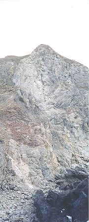
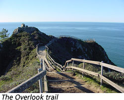
Muir Beach Overlook
Encyclopedia
Golden Gate National Recreation Area
The Golden Gate National Recreation Area is a U.S. National Recreation Area administered by the National Park Service that surrounds the San Francisco Bay area. It is one of the most visited units of the National Park system in the United States, with over 13 million visitors a year...
. People may visit this cliffside park when driving on State Route 1
California State Route 1
State Route 1 , more often called Highway 1, is a state highway that runs along much of the Pacific coast of the U.S. state of California. It is famous for running along some of the most beautiful coastlines in the world, leading to its designation as an All-American Road.Highway 1 does not run...
(also known as Highway 1) north of San Francisco, California
California
California is a state located on the West Coast of the United States. It is by far the most populous U.S. state, and the third-largest by land area...
and south of Stinson Beach, California
Stinson Beach, California
Stinson Beach is a census-designated place in Marin County, California, on the west coast of the United States. Stinson Beach is located east-southeast of Bolinas, at an elevation of 26 feet . The population of the Stinson Beach CDP was 632 at the 2010 census.Stinson Beach is about a 35-minute...
. It has views of Pacific oceanside cliffs and on clear days you can see San Francisco. You can also view migrating blue whales between November and June.
Location
Located 0.5 mile (0.80467 km) north of Muir Beach on Highway One in Marin CountyMarin County, California
Marin County is a county located in the North San Francisco Bay Area of the U.S. state of California, across the Golden Gate Bridge from San Francisco. As of 2010, the population was 252,409. The county seat is San Rafael and the largest employer is the county government. Marin County is well...
.
History
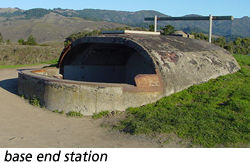
Muir Beach Overlook contains several historic base-end stationsBase end station
Base end stations were used by the U.S Coast Artillery as part of fire control systems for locating the positions of attacking ships and controlling the firing of seacoast guns, mortars, or mines to defend against them....
. From these stations, soldiers viewed ships and triangulated the distance, speed, and direction of these ships in coordination with different stations. These stations were mostly important for artillery units stationed on the coast to attack any invasion. They gained particular importance during World War II
World War II
World War II, or the Second World War , was a global conflict lasting from 1939 to 1945, involving most of the world's nations—including all of the great powers—eventually forming two opposing military alliances: the Allies and the Axis...
immediately after the bombing of Pearl Harbor when many in California feared San Francisco or Los Angeles
Los Angeles, California
Los Angeles , with a population at the 2010 United States Census of 3,792,621, is the most populous city in California, USA and the second most populous in the United States, after New York City. It has an area of , and is located in Southern California...
would be the next target. With the advent of radar and its widespread use, these stations became obsolete.
A few of them remain open like ruins
Ruins
Ruins are the remains of human-made architecture: structures that were once complete, as time went by, have fallen into a state of partial or complete disrepair, due to lack of maintenance or deliberate acts of destruction...
where you may enter them to get somewhat of a perspective of the soldiers who were therein stationed.
Pictures
| Top of Muir Beach Overlook | Base End Station at Muir Beach Overlook |
|---|---|
 |
 |