
Muir Beach, California
Encyclopedia
Muir Beach is a census-designated place
(CDP), unincorporated community, and beach that is located 16.5 miles (26.6 km) northwest of San Francisco in western Marin County
, California
, United States
. The population was 310 at the 2010 census.
Located about 2 miles (3 km) from the entrance to Muir Woods National Monument
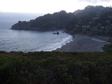
, the beach is about 1000 feet (305 m) long and 200 feet (61 m) wide, with coarse sand and several large boulders. There is a parking lot at the beach, which is then accessible via a footbridge. The community itself flanks the northwest side of the beach.
, the CDP has a total area of 0.5 square miles (1.3 km²), all of it land.
The beach is one of the cleanest in the state.
was 629.0 people per square mile (242.9/km²). The racial makeup of Muir Beach was 283 (91.3%) White, 5 (1.6%) African American, 1 (0.3%) Native American, 12 (3.9%) Asian, 1 (0.3%) from other races
, and 8 (2.6%) from two or more races. Hispanic or Latino of any race were 7 persons (2.3%).
The Census reported that 95.8% of the population lived in households and 4.2% lived in non-institutionalized group quarters.
There were 141 households, out of which 27 (19.1%) had children under the age of 18 living in them, 79 (56.0%) were opposite-sex married couples
living together, 4 (2.8%) had a female householder with no husband present, 3 (2.1%) had a male householder with no wife present. There were 11 (7.8%) unmarried opposite-sex partnerships
, and 1 (0.7%) same-sex married couples or partnerships. 39 households (27.7%) were made up of individuals and 11 (7.8%) had someone living alone who was 65 years of age or older. The average household size was 2.11. There were 86 families
(61.0% of all households); the average family size was 2.47.
The population was spread out with 38 people (12.3%) under the age of 18, 10 people (3.2%) aged 18 to 24, 56 people (18.1%) aged 25 to 44, 138 people (44.5%) aged 45 to 64, and 68 people (21.9%) who were 65 years of age or older. The median age was 52.6 years. For every 100 females there were 102.6 males. For every 100 females age 18 and over, there were 106.1 males.
There were 162 housing units at an average density of 328.7 per square mile (126.9/km²), of which 73.8% were owner-occupied and 26.2% were occupied by renters. The homeowner vacancy rate was 1.0%; the rental vacancy rate was 2.6%. 75.2% of the population lived in owner-occupied housing units and 20.6% lived in rental housing units.
of 2000, there were 295 people, 131 households, and 69 families residing in the CDP. The population density
was 596.8 people per square mile (232.4/km²). There were 144 housing units at an average density of 291.3 per square mile (113.5/km²). The racial makeup of the CDP in 2010 was 89.7% non-Hispanic White, 0.8% non-Hispanic African American, 3.9% Asian, and 2.6% from two or more races. Hispanic or Latino of any race were 2.3% of the population.
There were 131 households out of which 19.1% had children under the age of 18 living with them, 45.0% were married couples
living together, 5.3% had a female householder with no husband present, and 46.6% were non-families. 30.5% of all households were made up of individuals and 7.6% had someone living alone who was 65 years of age or older. The average household size was 2.22 and the average family size was 2.67.
In the CDP the population was spread out with 14.2% under the age of 18, 2.7% from 18 to 24, 26.1% from 25 to 44, 46.8% from 45 to 64, and 10.2% who were 65 years of age or older. The median age was 48 years. For every 100 females there were 90.3 males. For every 100 females age 18 and over, there were 91.7 males.
The median income for a household in the CDP was $125,402, and the median income for a family was $152,174. The per capita income
for the CDP was $66,476. None of the families and 10.5% of the population were living below the poverty line.
, Tamalpais Union High School District
, and the Marin Community College District
. Students attend public schools in or near Mill Valley
at Tamalpais Valley Elementary School (kindergarten - grade 5), Mill Valley Middle School (grades 6 - 8), and Tamalpais High School (grades 9 - 12).
, including law enforcement, land use planning, library, public health, and code enforcement. A special district, the Muir Beach Community Services District, provides local services, including fire protection, water, road maintenance, and recreation. The District has a board of directors, with five members elected to four-year terms. The District includes all of the Muir Beach CDP, plus Green Gulch Farm. (See map of MBCSD.)
Census-designated place
A census-designated place is a concentration of population identified by the United States Census Bureau for statistical purposes. CDPs are delineated for each decennial census as the statistical counterparts of incorporated places such as cities, towns and villages...
(CDP), unincorporated community, and beach that is located 16.5 miles (26.6 km) northwest of San Francisco in western Marin County
Marin County, California
Marin County is a county located in the North San Francisco Bay Area of the U.S. state of California, across the Golden Gate Bridge from San Francisco. As of 2010, the population was 252,409. The county seat is San Rafael and the largest employer is the county government. Marin County is well...
, California
California
California is a state located on the West Coast of the United States. It is by far the most populous U.S. state, and the third-largest by land area...
, United States
United States
The United States of America is a federal constitutional republic comprising fifty states and a federal district...
. The population was 310 at the 2010 census.
Located about 2 miles (3 km) from the entrance to Muir Woods National Monument
Muir Woods National Monument
Muir Woods National Monument is a unit of the National Park Service on the Pacific coast of southwestern Marin County, California, north of San Francisco and part of the Golden Gate National Recreation Area...
, the beach is about 1000 feet (305 m) long and 200 feet (61 m) wide, with coarse sand and several large boulders. There is a parking lot at the beach, which is then accessible via a footbridge. The community itself flanks the northwest side of the beach.
Geography
According to the United States Census BureauUnited States Census Bureau
The United States Census Bureau is the government agency that is responsible for the United States Census. It also gathers other national demographic and economic data...
, the CDP has a total area of 0.5 square miles (1.3 km²), all of it land.
The beach is one of the cleanest in the state.
2010
The 2010 United States Census reported that Muir Beach had a population of 310. The population densityPopulation density
Population density is a measurement of population per unit area or unit volume. It is frequently applied to living organisms, and particularly to humans...
was 629.0 people per square mile (242.9/km²). The racial makeup of Muir Beach was 283 (91.3%) White, 5 (1.6%) African American, 1 (0.3%) Native American, 12 (3.9%) Asian, 1 (0.3%) from other races
Race (United States Census)
Race and ethnicity in the United States Census, as defined by the Federal Office of Management and Budget and the United States Census Bureau, are self-identification data items in which residents choose the race or races with which they most closely identify, and indicate whether or not they are...
, and 8 (2.6%) from two or more races. Hispanic or Latino of any race were 7 persons (2.3%).
The Census reported that 95.8% of the population lived in households and 4.2% lived in non-institutionalized group quarters.
There were 141 households, out of which 27 (19.1%) had children under the age of 18 living in them, 79 (56.0%) were opposite-sex married couples
Marriage
Marriage is a social union or legal contract between people that creates kinship. It is an institution in which interpersonal relationships, usually intimate and sexual, are acknowledged in a variety of ways, depending on the culture or subculture in which it is found...
living together, 4 (2.8%) had a female householder with no husband present, 3 (2.1%) had a male householder with no wife present. There were 11 (7.8%) unmarried opposite-sex partnerships
POSSLQ
POSSLQ is an abbreviation for "Persons of Opposite Sex Sharing Living Quarters," a term coined in the late 1970s by the United States Census Bureau as part of an effort to more accurately gauge the prevalence of cohabitation in American households....
, and 1 (0.7%) same-sex married couples or partnerships. 39 households (27.7%) were made up of individuals and 11 (7.8%) had someone living alone who was 65 years of age or older. The average household size was 2.11. There were 86 families
Family (U.S. Census)
A family or family household is defined by the United States Census Bureau for statistical purposes as "a householder and one or more other people related to the householder by birth, marriage, or adoption. They do not include same-sex married couples even if the marriage was performed in a state...
(61.0% of all households); the average family size was 2.47.
The population was spread out with 38 people (12.3%) under the age of 18, 10 people (3.2%) aged 18 to 24, 56 people (18.1%) aged 25 to 44, 138 people (44.5%) aged 45 to 64, and 68 people (21.9%) who were 65 years of age or older. The median age was 52.6 years. For every 100 females there were 102.6 males. For every 100 females age 18 and over, there were 106.1 males.
There were 162 housing units at an average density of 328.7 per square mile (126.9/km²), of which 73.8% were owner-occupied and 26.2% were occupied by renters. The homeowner vacancy rate was 1.0%; the rental vacancy rate was 2.6%. 75.2% of the population lived in owner-occupied housing units and 20.6% lived in rental housing units.
2000
As of the censusCensus
A census is the procedure of systematically acquiring and recording information about the members of a given population. It is a regularly occurring and official count of a particular population. The term is used mostly in connection with national population and housing censuses; other common...
of 2000, there were 295 people, 131 households, and 69 families residing in the CDP. The population density
Population density
Population density is a measurement of population per unit area or unit volume. It is frequently applied to living organisms, and particularly to humans...
was 596.8 people per square mile (232.4/km²). There were 144 housing units at an average density of 291.3 per square mile (113.5/km²). The racial makeup of the CDP in 2010 was 89.7% non-Hispanic White, 0.8% non-Hispanic African American, 3.9% Asian, and 2.6% from two or more races. Hispanic or Latino of any race were 2.3% of the population.
There were 131 households out of which 19.1% had children under the age of 18 living with them, 45.0% were married couples
Marriage
Marriage is a social union or legal contract between people that creates kinship. It is an institution in which interpersonal relationships, usually intimate and sexual, are acknowledged in a variety of ways, depending on the culture or subculture in which it is found...
living together, 5.3% had a female householder with no husband present, and 46.6% were non-families. 30.5% of all households were made up of individuals and 7.6% had someone living alone who was 65 years of age or older. The average household size was 2.22 and the average family size was 2.67.
In the CDP the population was spread out with 14.2% under the age of 18, 2.7% from 18 to 24, 26.1% from 25 to 44, 46.8% from 45 to 64, and 10.2% who were 65 years of age or older. The median age was 48 years. For every 100 females there were 90.3 males. For every 100 females age 18 and over, there were 91.7 males.
The median income for a household in the CDP was $125,402, and the median income for a family was $152,174. The per capita income
Per capita income
Per capita income or income per person is a measure of mean income within an economic aggregate, such as a country or city. It is calculated by taking a measure of all sources of income in the aggregate and dividing it by the total population...
for the CDP was $66,476. None of the families and 10.5% of the population were living below the poverty line.
Education
Muir Beach is in the Mill Valley School DistrictMill Valley School District
The Mill Valley School District is located 13 miles north of San Francisco and the Golden Gate Bridge in Marin County, California. The district has 5 elementary schools and 1 middle school with an enrollment of approximately 2,200 students in grades K through 8...
, Tamalpais Union High School District
Tamalpais Union High School District
The Tamalpais Union High School District or TUHSD provides high school education to students residing in ten elementary districts in central and southern Marin County, California and parts of West Marin: Bolinas-Stinson Union, Kentfield, Lagunitas, Larkspur, Mill Valley, Nicasio, Reed Union, Ross,...
, and the Marin Community College District
College of Marin
The College of Marin is a community college in Marin County, California, U.S., with two campuses, one in Kentfield, and the second in Novato. It is the only institution operated by the Marin Community College District. Its chief executive officer is currently Superintendent/President David Wain...
. Students attend public schools in or near Mill Valley
Mill Valley, California
Mill Valley is a city in Marin County, California, United States located about north of San Francisco via the Golden Gate Bridge. The population was 13,903 at the 2010 census.Mill Valley is located on the western and northern shores of Richardson Bay...
at Tamalpais Valley Elementary School (kindergarten - grade 5), Mill Valley Middle School (grades 6 - 8), and Tamalpais High School (grades 9 - 12).
Local government
Muir Beach is unincorporated, receiving general government services from Marin CountyMarin County, California
Marin County is a county located in the North San Francisco Bay Area of the U.S. state of California, across the Golden Gate Bridge from San Francisco. As of 2010, the population was 252,409. The county seat is San Rafael and the largest employer is the county government. Marin County is well...
, including law enforcement, land use planning, library, public health, and code enforcement. A special district, the Muir Beach Community Services District, provides local services, including fire protection, water, road maintenance, and recreation. The District has a board of directors, with five members elected to four-year terms. The District includes all of the Muir Beach CDP, plus Green Gulch Farm. (See map of MBCSD.)