

Muddy River, Massachusetts
Encyclopedia
Emerald Necklace
The Emerald Necklace consists of an chain of parks linked by parkways and waterways in Boston and Brookline, Massachusetts. It gets its name from the way the planned chain appears to hang from the "neck" of the Boston peninsula, although it was never fully constructed.-Overview:The Necklace...
, including along the south boundary of Brookline, Massachusetts
Brookline, Massachusetts
Brookline is a town in Norfolk County, Massachusetts, United States, which borders on the cities of Boston and Newton. As of the 2010 census, the population of the town was 58,732.-Etymology:...
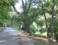
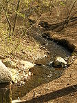
(a town that went by the name of Muddy River Hamlet before it was incorporated in 1705). The river, which is narrower than most waterways designated as rivers in the United States, is a protected public recreation area surrounded by parks and hiking trails, managed by the Massachusetts Department of Conservation and Recreation.
The river flows from Jamaica Pond
Jamaica Pond
Jamaica Pond is a kettle pond, part of the Emerald Necklace of parks in Boston designed by Frederick Law Olmsted. The pond and park are in the Jamaica Plain neighborhood of Boston, close to the border of Brookline...
through Olmsted Park
Olmsted Park
Olmsted Park is a linear park in Boston and Brookline, Massachusetts, and a part of Boston's Emerald Necklace of connected parks and parkways. Originally named Leverett Park, in 1900 it was renamed to honor its designer, Frederick Law Olmsted....
's Wards Pond, Willow Pond and Leverett Pond. It then flows through a conduit under Route 9
Route 9 (Massachusetts)
Route 9 is a major east–west state highway in Massachusetts. Along with U.S. Route 20, Route 2 and the Massachusetts Turnpike, Route 9 is one of the major east-west routes of Massachusetts, and like the others its eastern terminus is in Boston...
and into a narrow park called The Riverway
The Riverway
Riverway is a parkway in Boston, Massachusetts. The parkway is a link in the Emerald Necklace system of parks and parkways designed by Frederick Law Olmsted in the 1890s. Starting at the Landmark Center end of the Back Bay Fens, the parkway follows the path of the Muddy River south to Olmsted Park...
, from which it flows through underground pipes to a gatehouse located at Brookline Avenue. At this point some of the water runs north to drain into the Charles River
Charles River
The Charles River is an long river that flows in an overall northeasterly direction in eastern Massachusetts, USA. From its source in Hopkinton, the river travels through 22 cities and towns until reaching the Atlantic Ocean at Boston...
, while some drains into the Back Bay Fens
Back Bay Fens
The Back Bay Fens, most commonly called simply The Fens, is a parkland and urban wild in Boston, Massachusetts, in the United States.Designed by Frederick Law Olmsted to serve as a link in the Emerald Necklace park system, the Fens gives its name to the Fenway-Kenmore neighborhood, and thereby to...
, which were formerly a saltwater marsh. The Muddy River continues from the Fens in a stone-paved channel surrounded by a narrow strip of parklands, toward its connection with the Charles River
Charles River
The Charles River is an long river that flows in an overall northeasterly direction in eastern Massachusetts, USA. From its source in Hopkinton, the river travels through 22 cities and towns until reaching the Atlantic Ocean at Boston...
via the Charlesgate area. In a series of stone bridges and tunnels, it passes under Boylston Street
Boylston Street
Boylston Street is the name of a major east-west thoroughfare in the city of Boston, Massachusetts. Another Boylston Street runs through Boston's western suburbs....
, Massachusetts Turnpike
Massachusetts Turnpike
The Massachusetts Turnpike is the easternmost stretch of Interstate 90. The Turnpike begins at the western border of Massachusetts in West Stockbridge connecting with the Berkshire Connector portion of the New York State Thruway...
, Commonwealth Avenue
Commonwealth Avenue
Commonwealth Avenue is an avenue which may refer to:in Australia*Commonwealth Avenue, Canberrain the Philippines*Commonwealth Avenue, Quezon Cityin Singapore*Commonwealth Avenue, Singaporein the United States...
, Storrow Drive
Storrow Drive
Storrow Drive is a major cross town expressway in Boston, Massachusetts, running south and west from Leverett Circle along the Charles River. It is a parkway—it is restricted to cars; trucks and buses are not permitted on it...
, and a series of elevated connecting ramps (the Bowker Overpass
Bowker Overpass
The Bowker Overpass is a steel beam bridge with a suspended deck carrying Charlesgate Street over Commonwealth Avenue, Beacon Street, and Interstate 90. It connects Boylston Street to Storrow Drive. It runs parallel to the Muddy River...
).
History
Frederick Law Olmsted
Frederick Law Olmsted was an American journalist, social critic, public administrator, and landscape designer. He is popularly considered to be the father of American landscape architecture, although many scholars have bestowed that title upon Andrew Jackson Downing...
, under whose direction the project reclaimed marshland, creating sculpted and planted riverbanks.
Restoration
The river is currently undergoing a restoration project to improve flood control and water quality, enhance its aquaticAquatic ecosystem
An aquatic ecosystem is an ecosystem in a body of water. Communities of organisms that are dependent on each other and on their environment live in aquatic ecosystems. The two main types of aquatic ecosystems are marine ecosystems and freshwater ecosystems....
and riparian
Riparian zone
A riparian zone or riparian area is the interface between land and a river or stream. Riparian is also the proper nomenclature for one of the fifteen terrestrial biomes of the earth. Plant habitats and communities along the river margins and banks are called riparian vegetation, characterized by...
habitats, restore the landscape and historic resources, and implement improved management practices. This project is intended to prevent repeat occurrences of the Muddy River's past damaging floods.