

Mpulungu
Encyclopedia
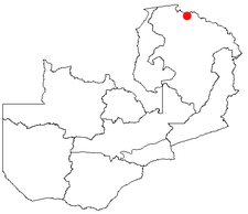
Northern Province, Zambia
Northern Province is one of Zambia's nine provinces. It covers approximately one fifth of Zambia in land area. The provincial capital is Kasama. The province is made up of 12 districts, namely Kasama , Chilubi, Isoka, Chinsali, Kaputa, Luwingu, Mbala, Mporokoso, Mpika, Mpulungu, Mungwi and Nakonde...
of Zambia
Zambia
Zambia , officially the Republic of Zambia, is a landlocked country in Southern Africa. The neighbouring countries are the Democratic Republic of the Congo to the north, Tanzania to the north-east, Malawi to the east, Mozambique, Zimbabwe, Botswana and Namibia to the south, and Angola to the west....
, at the southern tip of Lake Tanganyika
Lake Tanganyika
Lake Tanganyika is an African Great Lake. It is estimated to be the second largest freshwater lake in the world by volume, and the second deepest, after Lake Baikal in Siberia; it is also the world's longest freshwater lake...
.
From Mpulungu, boats reach DR Congo, Tanzania
Tanzania
The United Republic of Tanzania is a country in East Africa bordered by Kenya and Uganda to the north, Rwanda, Burundi, and the Democratic Republic of the Congo to the west, and Zambia, Malawi, and Mozambique to the south. The country's eastern borders lie on the Indian Ocean.Tanzania is a state...
and Burundi
Burundi
Burundi , officially the Republic of Burundi , is a landlocked country in the Great Lakes region of Eastern Africa bordered by Rwanda to the north, Tanzania to the east and south, and the Democratic Republic of the Congo to the west. Its capital is Bujumbura...
. The MV Liemba
MV Liemba
The MV Liemba, formerly the Graf von Götzen, is a passenger and cargo ferry that runs along the eastern shore of Lake Tanganyika...
ferry sails from Mpulungu to Kasanga
Kasanga
Kasanga is a town in southwestern Tanzania. It is located at around , on the shore of Lake Tanganyika, 810 m above sea level.-History:...
and Kigoma
Kigoma
Kigoma is a town and lake port in western Tanzania, on the eastern shore of Lake Tanganyika and close to the border with Burundi. It serves as the capital for the surrounding Kigoma Region and has a population of 135,234 and an elevation of 775 m.The historic trading town of Ujiji is 6 km...
in western Tanzania
Tanzania
The United Republic of Tanzania is a country in East Africa bordered by Kenya and Uganda to the north, Rwanda, Burundi, and the Democratic Republic of the Congo to the west, and Zambia, Malawi, and Mozambique to the south. The country's eastern borders lie on the Indian Ocean.Tanzania is a state...
, with connections from there to Bujumbura
Bujumbura
-Education:The University of Burundi is located in Bujumbura.Hope Africa University is located in BujumburaUniversité du Lac Tanganyika is located in Bujumbura-External links:**...
.
Mpulungu is also a fishing port and lies at the end of the old Great North Road
Great North Road (Zambia)
The Great North Road is a major route in Zambia, running north from Lusaka through Kabwe, Kapiri Mposhi Serenje, Mpika, Kasama, Mbala and Mpulungu. 82km North of Mpika is a signposted left turn onto a well maintained gravel road leading to Shiwa Ng'andu and Kapishya Hot Springs...
.
Transport
In 2007 it was proposed to give Mpulungu rail accessTransport in Zambia
-Railways in Zambia:Total: 2,164 km -Zambia Rail Network Map:-Principal lines:* Zambia Railways Limited — narrow gauge, 846 km Kitwe-Ndola-New Kapiri Mposhi-Kabwe-Lusaka-Livingstone-Zimbabwe with several freight branches mostly in the Copperbelt totalling 427 km including to DR Congo...
with a junction off the TAZARA line at Nseluka
Nseluka
- Transport :It has a station on the TAZARA railway. It is the proposed junction for a branch railway to Mpulungu on the shores of Lake Tanganyika....
. This link plus another between Mpika
Mpika
Mpika is a town in the Northern Province of Zambia, lying at the junction of the Great North Road to Kasama and Mbala and the Tanzam Highway to Dar es Salaam, Tanzania. It also has a railway station on the TAZARA Railway about 5 km away. Mpika is situated between the Muchinga Escarpment to...
and Mchinji
Mchinji
Mchinji is a town in the Mchinji District of the Central Region of Malawi. As of 2008 estimates, Mchinji has a population of 25,184. The area's economy is sustained by rain-fed agriculture, although the town is currently in the midst of a food crisis. Mchinji is also a major railroad junction,...
would greater shorten the rail distance to a deepwater port at Nacala
Nacala
Nacala, also known as Cidade de Nacala or Nacala-Porto is on the northern coast of Mozambique is the deepest natural port on the east coast of Africa. It serves as the terminal for the Nacala Railway, a rail link to the landlocked Malawi...
in Mozambique
Transport in Mozambique
- Railways :total:3,123 kmnarrow gauge:2,983 km of gauge;narrow gauge:140 km of gauge * The railways do not all interconnect.- Standards :* Coupler: CBC* Brakes: Air- Railway links to adjacent countries :...
.
History
In the period up to the First World War and for about a decade afterwards, all vessels at the southern end of Lake Tanganyika had to lie offshore at Katuta Bay and unload by lighter or local canoe. This was thought highly unsatisfactory as the SS Liemba was then exposed on a lee shore to storms from the Northerly trade winds which could cause a dangerous sharp swell in the shallow waters of the bay. Also the ship’s derricks could not be used efficiently to unload heavier or bulk cargoes like bags of cement or large oil drums.J.H. Venning, the British South Africa Company
British South Africa Company
The British South Africa Company was established by Cecil Rhodes through the amalgamation of the Central Search Association and the Exploring Company Ltd., receiving a royal charter in 1889...
Provincial Commissioner in Abercorn – then the Provincial Headquarters – had imported an ex Union Castle Line lifeboat that he used for fishing on the lake. During the course of these expeditions he had come to regard the channel between Kumbula Island and the shore line at Mpulungu as a safe haven. One evening he was discussing the Katuta Bay problem with the Captain of the SS Liemba and mentioned the protected channel. Between them they then formed a plan to take the Governor, who was to visit shortly, on a fishing trip.
The fishing expedition duly took place. Venning took his boat into the channel and they landed and had a splendid picnic provided by the cook of the SS Liemba. When everyone was comfortable and excellent fishing and a good lunch and been enjoyed Venning turned to the Captain of SS Liemba and said in as casual a tone of voice “Wouldn’t this make a good place for a harbour?”
The Captain then replied with enthusiasm pointing out its many advantages.
The Governor, at his ease and relaxed, then asked how much Venning thought it would cost. He probably thought that the cost would be so great that he could rule it out immediately.
But Venning said “ Well I think I could fix it up for about £100” While £100 was a considerable sum in those far off days it was still far below a realistic cost. Venning knew that the Governor had discretion to spend £100 on his own say-so without having to go through estimates, budget and treasury procedures.
The Governor, maybe by then Sir Herbert Stanley
Herbert Stanley
Sir Herbert James Stanley, GCMG was a leading British administrator, who served at different times as Governor of Northern Rhodesia, Ceylon and Southern Rhodesia....
, told Venning to go ahead.
Venning knew that, with a little judicious juggling of funds and the use of the prisoners from Abercorn jail, he could construct a road 26 miles long and a wharf and Customs warehouse.
This was duly done on “budget” and Mpulungu was founded as the southern Terminus of Lake Tanganyika.
See also
- Transport in ZambiaTransport in Zambia-Railways in Zambia:Total: 2,164 km -Zambia Rail Network Map:-Principal lines:* Zambia Railways Limited — narrow gauge, 846 km Kitwe-Ndola-New Kapiri Mposhi-Kabwe-Lusaka-Livingstone-Zimbabwe with several freight branches mostly in the Copperbelt totalling 427 km including to DR Congo...
- Railway stations in ZambiaRailway stations in ZambiaRailway stations in Zambia include:- Existing :- TAZARA :* Serenje* Mkushi - Tanzania / Zambian border* Chilanga Tunduma, Tanzania- Newly constructed : Mchinji - connects to Malawi Railways Chipata - railhead, Dry port- Proposed rail :...