
Mount Whitney trail
Encyclopedia
The Mount Whitney Trail is a trail that climbs Mount Whitney
. It starts at Whitney Portal
, 13 miles (20.9 km) west of the town of Lone Pine, California
. The hike is about 22 miles (35.4 km) round trip, with an elevation gain of over 6100 feet (1,859.3 m). It is an extremely popular trail, and its access is restricted by quotas from May to October.

 The original pack trail from Lone Pine to the summit of Mount Whitney was designed by local engineer Gustave Marsh. This original trail, opened on July 22, 1904, was the basis for most of today's Mount Whitney Trail.
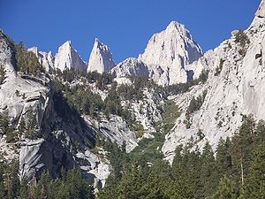
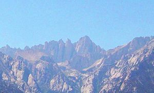
. Almost anyone in good physical shape with a desire to succeed has a good chance of hiking to the summit. The trail does not head up the direct route to the summit by the North Fork of Lone Pine Creek, as this is a very steep route used by mountaineers. Instead, it follows the gentler main branch of Lone Pine Creek to its source, and then climbs by 99 switchbacks to the Sierra crest about 2-1/2 miles south of the summit. The trail then travels very close to the crest of the range until reaching the summit plateau. This longer "dogleg" route makes possible a standard hiking trail. During peak season the trail is well-maintained and easy to follow. Once the mountain clears of snow and ice, usually in early to mid summer, it requires no mountaineering or winter gear. Beyond Trail Crest the trail loses a small amount of elevation that is gained on the return. In this final stretch of the trail, on the west side of Whitney's needle-like south ridge, some sections of the trail must be rebuilt after each winter. The views here of the interior High Sierra can be extraordinary, due in part to the precipitous exposure. The crowning views are had on the summit of Whitney, where the trail ends at the Smithsonian Institution Shelter
.
A single day hike of the trail usually starts between 2 and 4 AM. Most day hikers will complete the trip in between 10 and 20 hours. Because of the length, distance and high altitude of the trail, hiking it in a single day requires some fitness and endurance.
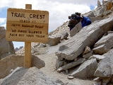
. Due to the high volume of trail users, the Forest Service enforces special regulations here to preserve Whitney's wild character. Wilderness permits are always required to use the trail, and between May 1 and November 1, a quota permits only 60 overnight users and 100 day users per day.
management was a major problem at Mount Whitney, and in 2006 the Inyo National Forest
instituted a mandatory "pack it out" program. The Forest Service removed the solar latrines at Outpost Camp and Trail Camp, and instead issue "WAG Bags" to trail users for human waste. Used bags must be deposited in special containers for that purpose located at the Whitney Portal trailhead.
; these can be rented at the Interagency Visitors Center south of Lone Pine or the Whitney Portal Store for a nominal fee. Black bears
are common along the Mount Whitney Trail. Night sightings of these bears are not unusual. When traveling at night, hikers are advised to wield a bright headlight and a shrill whistle; making many strange, loud noises will alert the bears to human presence. If possible, hikers should travel in a larger group as bears are much less likely to approach a group than a single person.
Mount Whitney
Mount Whitney is the highest summit in the contiguous United States with an elevation of . It is on the boundary between California's Inyo and Tulare counties, west-northwest of the lowest point in North America at Badwater in Death Valley National Park...
. It starts at Whitney Portal
Whitney Portal, California
Whitney Portal is an unincorporated community in Inyo County, California. It is located west of Lone Pine, at an elevation of 7851 feet . Whitney Portal, as its name suggests, is the gateway to Mount Whitney, the highest point in the contiguous United States; it is the trailhead for the Mount...
, 13 miles (20.9 km) west of the town of Lone Pine, California
Lone Pine, California
Lone Pine is a census-designated place in Inyo County, California, United States. Lone Pine is located south-southeast of Independence, at an elevation of 3727 feet . The population was 2,035 at the 2010 census, up from 1,655 at the 2000 census. The town is located in the Owens Valley, near the...
. The hike is about 22 miles (35.4 km) round trip, with an elevation gain of over 6100 feet (1,859.3 m). It is an extremely popular trail, and its access is restricted by quotas from May to October.
History
Route
The Mount Whitney Trail starts at Whitney PortalWhitney Portal, California
Whitney Portal is an unincorporated community in Inyo County, California. It is located west of Lone Pine, at an elevation of 7851 feet . Whitney Portal, as its name suggests, is the gateway to Mount Whitney, the highest point in the contiguous United States; it is the trailhead for the Mount...
. Almost anyone in good physical shape with a desire to succeed has a good chance of hiking to the summit. The trail does not head up the direct route to the summit by the North Fork of Lone Pine Creek, as this is a very steep route used by mountaineers. Instead, it follows the gentler main branch of Lone Pine Creek to its source, and then climbs by 99 switchbacks to the Sierra crest about 2-1/2 miles south of the summit. The trail then travels very close to the crest of the range until reaching the summit plateau. This longer "dogleg" route makes possible a standard hiking trail. During peak season the trail is well-maintained and easy to follow. Once the mountain clears of snow and ice, usually in early to mid summer, it requires no mountaineering or winter gear. Beyond Trail Crest the trail loses a small amount of elevation that is gained on the return. In this final stretch of the trail, on the west side of Whitney's needle-like south ridge, some sections of the trail must be rebuilt after each winter. The views here of the interior High Sierra can be extraordinary, due in part to the precipitous exposure. The crowning views are had on the summit of Whitney, where the trail ends at the Smithsonian Institution Shelter
Smithsonian Institution Shelter
The Smithsonian Institution Shelter, also known as the Mount Whitney Summit Shelter, was built in 1909 on the summit plateau of Mount Whitney, in the Sierra Nevada within Sequoia National Park, in California.-History:...
.
A single day hike of the trail usually starts between 2 and 4 AM. Most day hikers will complete the trip in between 10 and 20 hours. Because of the length, distance and high altitude of the trail, hiking it in a single day requires some fitness and endurance.
Management
The Mount Whitney Trail, from above Lone Pine Lake to Trail Crest, lies within the special Mount Whitney Zone of the Inyo National ForestInyo National Forest
Inyo National Forest is a federally administered forest in the United States. The forest covers parts of the eastern Sierra Nevada of California, and the White Mountains of California and Nevada. It contains two wilderness areas: the John Muir Wilderness and the Ansel Adams Wilderness...
. Due to the high volume of trail users, the Forest Service enforces special regulations here to preserve Whitney's wild character. Wilderness permits are always required to use the trail, and between May 1 and November 1, a quota permits only 60 overnight users and 100 day users per day.
Camping
Camping is allowed along most of the trail, more than 100 feet (30.5 m) from water, but level ground that meets that description is extremely limited, so most backpackers congregate in two camps. Outpost Camp, the lower of the two camps, is 3.8 miles (6.1 km) by trail from Whitney Portal, at 10365 feet (3,159.3 m). It is sheltered by trees, near a waterfall and Bighorn Meadow. Trail Camp, is 6.3 miles (10.1 km) from the trail head at 12000 feet (3,657.6 m), in a rocky, often windy, alpine basin. This is also the last place where there is a reliable water source. The lake at the trail camp has algae from the human waste deposits and is usually purified before drinking. A water pump, or purifying and neutralizing tablets, work well. Depending on conditions, clean water may be found in springs on the switchbacks. Most overnight backpackers will take between 2 and 4 days to complete this trip.Human waste
Human wasteHuman waste
Human waste is a waste type usually used to refer to byproducts of digestion, such as feces and urine. Human waste is most often transported as sewage in waste water through sewerage systems...
management was a major problem at Mount Whitney, and in 2006 the Inyo National Forest
Inyo National Forest
Inyo National Forest is a federally administered forest in the United States. The forest covers parts of the eastern Sierra Nevada of California, and the White Mountains of California and Nevada. It contains two wilderness areas: the John Muir Wilderness and the Ansel Adams Wilderness...
instituted a mandatory "pack it out" program. The Forest Service removed the solar latrines at Outpost Camp and Trail Camp, and instead issue "WAG Bags" to trail users for human waste. Used bags must be deposited in special containers for that purpose located at the Whitney Portal trailhead.
Bear canisters
From May 25 to October 31, backpackers are required to carry a bear-resistant canisterBear-resistant food storage container
Bear-resistant food storage containers, commonly called bear canisters or simply bear cans, are usually hard-sided containers used by backpackers to protect their food from theft by bears...
; these can be rented at the Interagency Visitors Center south of Lone Pine or the Whitney Portal Store for a nominal fee. Black bears
American black bear
The American black bear is a medium-sized bear native to North America. It is the continent's smallest and most common bear species. Black bears are omnivores, with their diets varying greatly depending on season and location. They typically live in largely forested areas, but do leave forests in...
are common along the Mount Whitney Trail. Night sightings of these bears are not unusual. When traveling at night, hikers are advised to wield a bright headlight and a shrill whistle; making many strange, loud noises will alert the bears to human presence. If possible, hikers should travel in a larger group as bears are much less likely to approach a group than a single person.