

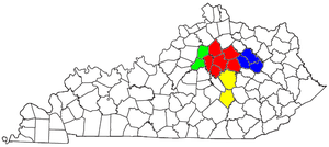
Mount Sterling micropolitan area
Encyclopedia
United States Census Bureau
The United States Census Bureau is the government agency that is responsible for the United States Census. It also gathers other national demographic and economic data...
, is an area consisting of three counties in Kentucky
Kentucky
The Commonwealth of Kentucky is a state located in the East Central United States of America. As classified by the United States Census Bureau, Kentucky is a Southern state, more specifically in the East South Central region. Kentucky is one of four U.S. states constituted as a commonwealth...
, anchored by the city of Mount Sterling
Mount Sterling, Kentucky
The Mt. Sterling-Montgomery County Library was established in 1871. The Mt. Sterling – Montgomery County Library moved to the current location, accessible from both Main and Locust Streets, in July 1984. The building was officially dedicated on September 30, 1984...
. As of the 2000 census
United States Census, 2000
The Twenty-second United States Census, known as Census 2000 and conducted by the Census Bureau, determined the resident population of the United States on April 1, 2000, to be 281,421,906, an increase of 13.2% over the 248,709,873 persons enumerated during the 1990 Census...
, the μSA had a population of 40,195 (though a July 1, 2009 estimate placed the population at 44,046).
The Mount Sterling Micropolitan Statistical Area is part of the Lexington
Lexington, Kentucky
Lexington is the second-largest city in Kentucky and the 63rd largest in the US. Known as the "Thoroughbred City" and the "Horse Capital of the World", it is located in the heart of Kentucky's Bluegrass region...
–Fayette
Fayette County, Kentucky
Fayette County is a county located in the U.S. state of Kentucky. The population was 295,083 in the 2010 Census. Its territory, population and government are coextensive with the city of Lexington, which also serves as county seat....
–Frankfort
Frankfort, Kentucky
Frankfort is a city in Kentucky that serves as the state capital and the county seat of Franklin County. The population was 27,741 at the 2000 census; by population it is the 5th smallest state capital in the United States...
–Richmond
Richmond, Kentucky
There were 10,795 households out of which 24.4% had children under the age of 18 living with them, 35.2% were married couples living together, 12.8% had a female householder with no husband present, and 48.6% were non-families. Of all households, 34.7% were made up of individuals and 8.8% had...
Combined Statistical Area
Lexington-Fayette-Frankfort-Richmond, KY Combined Statistical Area
The Lexington-Fayette-Frankfort-Richmond, KY Combined Statistical Area, created by the United States Bureau of the Census in 2000, is the 76th largest Combined Statistical Area of the United States...
.
Counties
- BathBath County, KentuckyBath County is a county located in the U.S. state of Kentucky. It was formed in 1811. As of 2010 the population is 11,591. Its county seat is Owingsville, Kentucky...
- MenifeeMenifee County, KentuckyMenifee County is a county located in the U.S. state of Kentucky. As of 2000, the population was 6,556. Its county seat is Frenchburg. The county is named for Richard Hickman Menefee, U.S. Congressman, although the spelling has changed. It is a prohibition or dry county.Menifee County is located...
- MontgomeryMontgomery County, KentuckyMontgomery County is a county located in the U.S. state of Kentucky. The population was 26,499. Its county seat is Mount Sterling. With regard to the sale of alcohol, it is classified as a moist county—a county in which alcohol sales are prohibited , but containing a "wet" city where package...
Places with more than 5,000 inhabitants
- Mount SterlingMount Sterling, KentuckyThe Mt. Sterling-Montgomery County Library was established in 1871. The Mt. Sterling – Montgomery County Library moved to the current location, accessible from both Main and Locust Streets, in July 1984. The building was officially dedicated on September 30, 1984...
(Principal city)
Places with 1,000 to 5,000 inhabitants
- JeffersonvilleJeffersonville, KentuckyThere were 682 households out of which 38.4% had children under the age of 18 living with them, 61.6% were married couples living together, 12.3% had a female householder with no husband present, and 22.9% were non-families. 19.6% of all households were made up of individuals and 8.8% had someone...
- OwingsvilleOwingsville, KentuckyOwingsville is a city in Bath County, Kentucky, United States. The population was 1,488 at the 2000 census. It is the county seat of Bath County, and is roughly in the center of the county, at the junction of US 60 and Kentucky Route 36....
Places with less than 1,000 inhabitants
- CamargoCamargo, KentuckyAs of the census of 2000, there were 923 people, 362 households, and 275 families residing in the city. The population density was 436.6 people per square mile . There were 383 housing units at an average density of 181.2 per square mile . The racial makeup of the city was 98.70% White, 0.11%...
- FrenchburgFrenchburg, KentuckyFrenchburg is a city in Menifee County, Kentucky, United States. The population was 551 at the 2000 census. It is the county seat of Menifee County, and the only incorporated city in the rural county. It is located at the junction of US 460 and Kentucky Route 36...
- Salt LickSalt Lick, KentuckySalt Lick is a city in Bath County, Kentucky, United States. The population was 342 at the 2000 census. It is part of the Mount Sterling Micropolitan Statistical Area.-Geography:Salt Lick is located at ....
- SharpsburgSharpsburg, KentuckySharpsburg is a city in Bath County, Kentucky, United States. The population was 295 at the 2000 census. It is part of the Mount Sterling Micropolitan Statistical Area.-Geography:Sharpsburg is located at ....
Unincorporated places
- DennistonDenniston, KentuckyDenniston is an unincorporated community in Menifee County, Kentucky, United States. It lies along U.S. Route 460 and Kentucky Route 746 southeast of the city of Frenchburg, the county seat of Menifee County. Its elevation is 1,106 feet...
- JudyJudy, KentuckyJudy is a small unincorporated farming village in Montgomery County, Kentucky, United States, located north of Mount Sterling. It lies on the Bath County and Montgomery County border and is most noted for having one of the few remaining operating drive-in theaters in the state.The community is...
- KoreaKorea, KentuckyKorea is an unincorporated community in Menifee County, Kentucky, United States. It lies along Route 1693 east of the city of Frenchburg, the county seat of Menifee County. Its elevation is 1,119 feet ....
- MaribaMariba, KentuckyMariba is an unincorporated community in Menifee County, Kentucky, United States. It lies along U.S. Route 460 and Kentucky Route 77 southeast of the city of Frenchburg, the county seat of Menifee County. Its elevation is 1,175 feet...
- MeansMeans, KentuckyMeans is an unincorporated community in Menifee County, Kentucky, United States. It lies along U.S. Route 460 and Kentucky Route 713 west of the city of Frenchburg, the county seat of Menifee County. Its elevation is 850 feet...
- PomeroytonPomeroyton, KentuckyPomeroyton is an unincorporated community in Menifee County, Kentucky, United States. It lies along Route 746 southeast of the city of Frenchburg, the county seat of Menifee County. Its elevation is 1,043 feet ....
- ScrantonScranton, KentuckyScranton is an unincorporated community in Menifee County, Kentucky, United States. It lies along Route 1274 northeast of the city of Frenchburg, the county seat of Menifee County. Its elevation is 791 feet ....
- SudithSudith, KentuckySudith is an unincorporated community in Menifee County, Kentucky, United States. It lies along Route 36 north of the city of Frenchburg, the county seat of Menifee County. Its elevation is 751 feet ....
- WellingtonWellington, Menifee County, KentuckyWellington is an unincorporated community in Menifee County, Kentucky, United States. It lies along U.S. Route 460 and Kentucky Route 1693 southeast of the city of Frenchburg, the county seat of Menifee County. Its elevation is 1,194 feet...
Demographics
As of the censusCensus
A census is the procedure of systematically acquiring and recording information about the members of a given population. It is a regularly occurring and official count of a particular population. The term is used mostly in connection with national population and housing censuses; other common...
of 2000, there were 40,195 people, 15,884 households, and 11,531 families residing within the μSA. The racial makeup of the μSA was 95.98% White, 2.68% African American, 0.16% Native American, 0.07% Asian, 0.02% Pacific Islander, 0.33% from other races
Race (United States Census)
Race and ethnicity in the United States Census, as defined by the Federal Office of Management and Budget and the United States Census Bureau, are self-identification data items in which residents choose the race or races with which they most closely identify, and indicate whether or not they are...
, and 0.75% from two or more races. Hispanic or Latino of any race were 1.05% of the population.
The median income for a household in the μSA was $26,609, and the median income for a family was $31,674. Males had a median income of $28,295 versus $19,647 for females. The per capita income
Per capita income
Per capita income or income per person is a measure of mean income within an economic aggregate, such as a country or city. It is calculated by taking a measure of all sources of income in the aggregate and dividing it by the total population...
for the μSA was $14,475.