

Mount Sonder
Encyclopedia
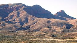
Mount Sonder, or Rwetyepme, its Aboriginal
name, is the fourth highest mountain
in the Northern Territory
, Australia
at 1380 metres above sea level. Mount Zeil
is the highest at 1531 metres, 27 kilometres to the west. It is 130 km (81 mi) west of Alice Springs
along the MacDonnell Ranges
in the West MacDonnell National Park
. It marks one end of the celebrated Larapinta trail
, which extends 223 kilometres to Alice Springs. The shape of the mountain is a double peak, the relative heights of which are somewhat ambiguous from the summit, although easy to identify from the surrounding plains. The mountain can be seen for the western half of the Larapinta trail, up to Ormiston Pound
, which obscures it from then on.
A clearly defined walking track exists up the western side, taking about 12 kilometres. Water is available from a water tank 50 m beyond the carpark, and a direction plate can be found at the summit. This however is not the true summit, which is 750m away, but has been chosen for safety reasons. The view from the top boasts the taller Mount Zeil to the west, the West MacDonnell Range to the east, Glen Helen , a nearby resort, to the east and Gosses Bluff
to the south west on a clear day.
Indigenous Australians
Indigenous Australians are the original inhabitants of the Australian continent and nearby islands. The Aboriginal Indigenous Australians migrated from the Indian continent around 75,000 to 100,000 years ago....
name, is the fourth highest mountain
Mountain
Image:Himalaya_annotated.jpg|thumb|right|The Himalayan mountain range with Mount Everestrect 58 14 160 49 Chomo Lonzorect 200 28 335 52 Makalurect 378 24 566 45 Mount Everestrect 188 581 920 656 Tibetan Plateaurect 250 406 340 427 Rong River...
in the Northern Territory
Northern Territory
The Northern Territory is a federal territory of Australia, occupying much of the centre of the mainland continent, as well as the central northern regions...
, Australia
Australia
Australia , officially the Commonwealth of Australia, is a country in the Southern Hemisphere comprising the mainland of the Australian continent, the island of Tasmania, and numerous smaller islands in the Indian and Pacific Oceans. It is the world's sixth-largest country by total area...
at 1380 metres above sea level. Mount Zeil
Mount Zeil
Mount Zeil is a mountain situated in the western MacDonnell Ranges in Australia's Northern Territory. It is the highest peak in the Northern Territory, and the highest peak in Australia west of the Great Dividing Range .It is believed that Mount Zeil was named during or following Ernest Giles'...
is the highest at 1531 metres, 27 kilometres to the west. It is 130 km (81 mi) west of Alice Springs
Alice Springs, Northern Territory
Alice Springs is the second largest town in the Northern Territory of Australia. Popularly known as "the Alice" or simply "Alice", Alice Springs is situated in the geographic centre of Australia near the southern border of the Northern Territory...
along the MacDonnell Ranges
MacDonnell Ranges
The MacDonnell Ranges of the Northern Territory, are a long series of mountain ranges located in the centre of Australia , and consist of parallel ridges running to the east and west of Alice Springs...
in the West MacDonnell National Park
West MacDonnell National Park
West MacDonnell is a national park in the Northern Territory , 1234 km south of Darwin. It extends along the MacDonnell Ranges west of Alice Springs....
. It marks one end of the celebrated Larapinta trail
Larapinta Trail
The Larapinta Trail is an extended walking track in the Northern Territory, Australia. Its total length covers from East to West, with one end at Alice Springs and the other at Mount Sonder, one of the territory's highest mountains...
, which extends 223 kilometres to Alice Springs. The shape of the mountain is a double peak, the relative heights of which are somewhat ambiguous from the summit, although easy to identify from the surrounding plains. The mountain can be seen for the western half of the Larapinta trail, up to Ormiston Pound
Ormiston Pound
Ormiston Pound is a ring of mountains punctuating the MacDonnell Ranges, in the West MacDonnell National Park, approximately 135 kilometres west of Alice Springs in the Northern Territory, Australia...
, which obscures it from then on.
A clearly defined walking track exists up the western side, taking about 12 kilometres. Water is available from a water tank 50 m beyond the carpark, and a direction plate can be found at the summit. This however is not the true summit, which is 750m away, but has been chosen for safety reasons. The view from the top boasts the taller Mount Zeil to the west, the West MacDonnell Range to the east, Glen Helen , a nearby resort, to the east and Gosses Bluff
Gosses Bluff crater
Gosses Bluff is thought to be the eroded remnant of an impact crater. It is located in the southern Northern Territory, near the centre of Australia, about west of Alice Springs and about to the northeast of Uluru...
to the south west on a clear day.