

Mount Nyangani
Encyclopedia
Mount Nyangani is the highest mountain in Zimbabwe
at 2,592 m (8,504 ft). The mountain is located within Nyanga National Park
in Nyanga
District, is about 275 km (170.9 mi) south east of Harare
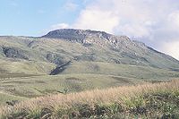
. The summit lies atop a small outcrop of rock around 40m above the surrounding area. The remainder of the peak is a broad moor of mainly rolling hills and plateau with an area of about 8 km2. The edges of this plateau then fall steeply to the east and west sides. The mountain vegetation is largely composed of heath around the summit plateau with evergereen forest along the wetter eastern slopes and grassland to the western side. Annual rainfall totals are high (around 2200 mm) but long spells of dry weather occur during the winter period of May to August. Due to its relatively low altitude and tropical location, snow falls very rarely, last recorded in August 1935.
of dolerite and sandstone
, with the harder dolerite forming cliffs and ridges. The dolerite sill and the sediments underlying it are probably part of the Umkondo Group. The Umkondo Group dolerite sill north of Nyangani, on the Kwaraguza Road, has been dated
at 1099 Ma
:
(1) The official car park, at the base of the Tourist Route. This is reached from Circular Drive.
(2) The Mountain Club of Zimbabwe hut, on the Kwaraguza Road, accessed via Circular Drive.
(3) Nyazengu Substation of Nyanga National Park, accessed via a road which goes south from just before the official car park.
(4) Gleneagles Substation of Nyanga National Park, accessed via the Circular Drive, Kwaraguza Road and the Gleneagles road or from Troutbeck
via Nyafaru.
 The peak can be reached within 1–3 hours by anyone of average fitness. This ascent brings the hiker to an altitude of about 2200m and the remainder is mostly walking across the gentler gradients of the summit plateau. The hazards here are produced by bewilderingly fast weather changes that can switch from sunny skies to thick fog, and under these conditions several fatalities have occurred due to hikers losing their way and falling down ravines. There are three ascents that follow paths:
The mountain can also be ascended using the following routes which do not have paths or markings:
The above are all walks or scrambles, without rock climbing involved. However, caution is advised, especially on unmarked routes, as the weather may change very rapidly: descent of cloud can result in visibility of less than 50 m. This may well be the cause for a number of disappearances on the mountain, such as that of two teenage children of the then Minister of Finance, Tichaendepi Masaya.
 Three rivers have their sources on Mount Nyangani: the Nyamuziwa River, the Kairezi (Gairezi) River and the Pungwe River
. The first two are tributaries of the Mazowe River, which is itself a tributary of the Zambezi River.
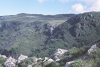
The Nyama River, a tributary of the Kayirezi, falls off the main plateau in a waterfall on the northeast of the mountain and the Kairezi Falls are located on the east edge of the main plateau.
. Additional information:
Zimbabwe
Zimbabwe is a landlocked country located in the southern part of the African continent, between the Zambezi and Limpopo rivers. It is bordered by South Africa to the south, Botswana to the southwest, Zambia and a tip of Namibia to the northwest and Mozambique to the east. Zimbabwe has three...
at 2,592 m (8,504 ft). The mountain is located within Nyanga National Park
Nyanga National Park
Nyanga National Park lies in the north of Zimbabwe's Eastern Highlands. One of the first national parks to be declared in the country, it contains the highest land in Zimbabwe, with green hills and perennial rivers. Most of its terrain consists of rolling downland, sometimes lightly wooded, lying...
in Nyanga
Nyanga
Nyanga may mean:*Nyanga Province, of Gabon*Nyanga, Gabon, a place in the province of Nyanga in Gabon*Nyanga River, in Gabon and Congo*Nyanga, Zimbabwe, a town*Nyanga National Park in Zimbabwe*Nyanga, Cape Town, a township in South Africa...
District, is about 275 km (170.9 mi) south east of Harare
Harare
Harare before 1982 known as Salisbury) is the largest city and capital of Zimbabwe. It has an estimated population of 1,600,000, with 2,800,000 in its metropolitan area . Administratively, Harare is an independent city equivalent to a province. It is Zimbabwe's largest city and its...
. The summit lies atop a small outcrop of rock around 40m above the surrounding area. The remainder of the peak is a broad moor of mainly rolling hills and plateau with an area of about 8 km2. The edges of this plateau then fall steeply to the east and west sides. The mountain vegetation is largely composed of heath around the summit plateau with evergereen forest along the wetter eastern slopes and grassland to the western side. Annual rainfall totals are high (around 2200 mm) but long spells of dry weather occur during the winter period of May to August. Due to its relatively low altitude and tropical location, snow falls very rarely, last recorded in August 1935.
Geology
The mountain is composed of an upper sillSill (geology)
In geology, a sill is a tabular sheet intrusion that has intruded between older layers of sedimentary rock, beds of volcanic lava or tuff, or even along the direction of foliation in metamorphic rock. The term sill is synonymous with concordant intrusive sheet...
of dolerite and sandstone
Sandstone
Sandstone is a sedimentary rock composed mainly of sand-sized minerals or rock grains.Most sandstone is composed of quartz and/or feldspar because these are the most common minerals in the Earth's crust. Like sand, sandstone may be any colour, but the most common colours are tan, brown, yellow,...
, with the harder dolerite forming cliffs and ridges. The dolerite sill and the sediments underlying it are probably part of the Umkondo Group. The Umkondo Group dolerite sill north of Nyangani, on the Kwaraguza Road, has been dated
Radiometric dating
Radiometric dating is a technique used to date materials such as rocks, usually based on a comparison between the observed abundance of a naturally occurring radioactive isotope and its decay products, using known decay rates...
at 1099 Ma
Access
The mountain can be accessed from four base points within Nyanga National ParkNyanga National Park
Nyanga National Park lies in the north of Zimbabwe's Eastern Highlands. One of the first national parks to be declared in the country, it contains the highest land in Zimbabwe, with green hills and perennial rivers. Most of its terrain consists of rolling downland, sometimes lightly wooded, lying...
:
(1) The official car park, at the base of the Tourist Route. This is reached from Circular Drive.
(2) The Mountain Club of Zimbabwe hut, on the Kwaraguza Road, accessed via Circular Drive.
(3) Nyazengu Substation of Nyanga National Park, accessed via a road which goes south from just before the official car park.
(4) Gleneagles Substation of Nyanga National Park, accessed via the Circular Drive, Kwaraguza Road and the Gleneagles road or from Troutbeck
Troutbeck, Manicaland
Troutbeck is a village in the province of Manicaland, Zimbabwe located in the Eastern Highlands on the northern border of Nyanga National Park and situated on a highland plateau at an altitude of about 2100m.-Tourism:...
via Nyafaru.
Mountain Hikes
- The main access to the mountain is a Tourist Path from the west. This ascends along the edge of the upper Nyamuziwa river and crosses onto the main plateau north of the summit. From there it heads south across the plateau to the summit.
- A second path runs from the Mountain Club of Zimbabwe hut. This paths follows the east side of the northern ridge, before joining the Tourist Path on the main plateau .
- A third path runs from Nyazengu, southwest of the mountain on the old road to the Pungwe RiverPungwe RiverPungwe River is a 400 km long river in Zimbabwe and Mozambique. It rises below Mount Nyangani in the Eastern Highlands of Zimbabwe and then flows eastward through the Manica and Sofala provinces of Mozambique. It then empties to the Mozambique Channel in Beira, forming a large estuary...
causeway (Pungwe Drift). It branches from the Nyazengu Trail and ascends to the base of Tucker's Gap, which has a spectacular view of the montane rainforest to the southeast of the mountain (on the few days when the cloud does not cover the Gap). It is possible to ascend the north side of the gap (marked path) and then walk northwards across a boulder field to the main plateau, apporoaching the summit from the south. However, this last stretch has no path or markings.
The mountain can also be ascended using the following routes which do not have paths or markings:
- The north-eastern ridge, between the Nyama and Kairezi Rivers. This route starts from the Gleneages Road, between the Nyama and Kairezi causeways, and follows a ridge up to the main plateau, northeast of the summit and east of the Tourist Path.
- Via Little Nyangani. This route starts from Gleneagles Substation, and ascends the heavily vegetated slope of Little Nyangani mountain, which lies to the east of the main plateau. From Little Nyangani, one can descend west to a rainforest-covered saddle, then ascend west onto the main plateau via Kairezi Falls, reaching the main plateau east of the summit.
The above are all walks or scrambles, without rock climbing involved. However, caution is advised, especially on unmarked routes, as the weather may change very rapidly: descent of cloud can result in visibility of less than 50 m. This may well be the cause for a number of disappearances on the mountain, such as that of two teenage children of the then Minister of Finance, Tichaendepi Masaya.
Rivers and Waterfalls
Pungwe River
Pungwe River is a 400 km long river in Zimbabwe and Mozambique. It rises below Mount Nyangani in the Eastern Highlands of Zimbabwe and then flows eastward through the Manica and Sofala provinces of Mozambique. It then empties to the Mozambique Channel in Beira, forming a large estuary...
. The first two are tributaries of the Mazowe River, which is itself a tributary of the Zambezi River.
The Nyama River, a tributary of the Kayirezi, falls off the main plateau in a waterfall on the northeast of the mountain and the Kairezi Falls are located on the east edge of the main plateau.
Fauna
The fauna of the area is described under Nyanga National ParkNyanga National Park
Nyanga National Park lies in the north of Zimbabwe's Eastern Highlands. One of the first national parks to be declared in the country, it contains the highest land in Zimbabwe, with green hills and perennial rivers. Most of its terrain consists of rolling downland, sometimes lightly wooded, lying...
. Additional information:
- The clawless otterOtterThe Otters are twelve species of semi-aquatic mammals which feed on fish and shellfish, and also other invertebrates, amphibians, birds and small mammals....
is common in the upper Kairezi River, near the mountain
- The Inyangani River FrogInyangani River FrogThe Inyangani River Frog is a species of frog in the Ranidae family.It is found in Zimbabwe and possibly Mozambique.Its natural habitats are subtropical or tropical high-altitude grassland and rivers....
is an endangered amphibian named for the mountain. It can be found in rocky, fast-flowing streams in the montane grassland.