
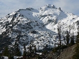
Mount Daniel
Encyclopedia
Mount Daniel is the highest summit on the Cascade Range
crest of Alpine Lakes Wilderness
of the central Washington, USA
. It is the highest point in King and Kittitas counties. Streams on its eastern slopes form the headwaters of the Cle Elum River
.
, dacite
, and rhyolite
inflows, breccia
, and tuff
. Volcanic sandstone is interbedded. Just west of Mount Daniel is the Mount Hinman pluton
ic stock.
These elevations are based on Sea Level Datum of 1929
and are taken from the Mount Daniels 7.5 minute topographic map which was published in 1965. The United States Board on Geographic Names
has assigned the name Mount Daniel to the east peak even thought it is not the highest.
 Mount Daniel supports several glaciers, the largest of which is Lynch Glacier on the northwest slope of the mountain. Lynch Glacier extends from 7800 feet (2,377 m) to 6220 feet (1,896 m), where it melts into Pea Soup Lake, draining to the East Fork Foss River
. The West Lynch Glacier hangs from the north slope of the Northwest Peak of Mount Daniel. West Lynch Glacier was formerly connected to Lynch Glacier. On the north side of the ridge between the Middle Summit and East Peak is another glacier with the tentative name of Daniel Glacier. It is partially connected to Lynch Glacier. Daniel Glacier is losing mass and was once much larger. Several small remnants, now just perennial snow accumulations rather than living glaciers, are located east of Daniel Glacier. On the southeast side of Mount Daniel, nested against a cirque headwall, is the Hyas Creek Glacier, an isolated and small ice mass that was once much larger. It drains to Hyas Creek and Peggys Pond. All the glaciers on Mount Daniel are thinning and becoming stagnant. West Lynch Glacier is expected to disappear in the near future.
(shown right), Peggys Pond, and then is a scramble up to summit.
Cascade Range
The Cascade Range is a major mountain range of western North America, extending from southern British Columbia through Washington and Oregon to Northern California. It includes both non-volcanic mountains, such as the North Cascades, and the notable volcanoes known as the High Cascades...
crest of Alpine Lakes Wilderness
Alpine Lakes Wilderness
The Alpine Lakes Wilderness is a large wilderness area spanning the Cascade Range of Washington state in the United States. The wilderness is located in parts of Wenatchee National Forest and Snoqualmie National Forest, and is approximately bounded by Interstate 90 and Snoqualmie Pass to the south...
of the central Washington, USA
United States
The United States of America is a federal constitutional republic comprising fifty states and a federal district...
. It is the highest point in King and Kittitas counties. Streams on its eastern slopes form the headwaters of the Cle Elum River
Cle Elum River
The Cle Elum River is a tributary of the Yakima River, approximately 28 miles long in the U.S. state of Washington.The river originates in the Cascade Range near Mount Daniel and flows generally south, through Hyas Lake. The river is joined by many tributary streams including Waptus River and...
.
Geology
Mount Daniel's volcanic rock is composed of andesiteAndesite
Andesite is an extrusive igneous, volcanic rock, of intermediate composition, with aphanitic to porphyritic texture. In a general sense, it is the intermediate type between basalt and dacite. The mineral assemblage is typically dominated by plagioclase plus pyroxene and/or hornblende. Magnetite,...
, dacite
Dacite
Dacite is an igneous, volcanic rock. It has an aphanitic to porphyritic texture and is intermediate in composition between andesite and rhyolite. The relative proportions of feldspars and quartz in dacite, and in many other volcanic rocks, are illustrated in the QAPF diagram...
, and rhyolite
Rhyolite
This page is about a volcanic rock. For the ghost town see Rhyolite, Nevada, and for the satellite system, see Rhyolite/Aquacade.Rhyolite is an igneous, volcanic rock, of felsic composition . It may have any texture from glassy to aphanitic to porphyritic...
inflows, breccia
Breccia
Breccia is a rock composed of broken fragments of minerals or rock cemented together by a fine-grained matrix, that can be either similar to or different from the composition of the fragments....
, and tuff
Tuff
Tuff is a type of rock consisting of consolidated volcanic ash ejected from vents during a volcanic eruption. Tuff is sometimes called tufa, particularly when used as construction material, although tufa also refers to a quite different rock. Rock that contains greater than 50% tuff is considered...
. Volcanic sandstone is interbedded. Just west of Mount Daniel is the Mount Hinman pluton
Pluton
A pluton in geology is a body of intrusive igneous rock that crystallized from magma slowly cooling below the surface of the Earth. Plutons include batholiths, dikes, sills, laccoliths, lopoliths, and other igneous bodies...
ic stock.
Peaks
From most vantages Mount Daniel appears to be a triple-crowned mass, but five summits can be identified.- West Summit (7960+ ft/2426+ m)
- Middle Summit (7959 ft (2,426 m))
- East Peak (7899 ft (2,408 m))
- West Pyramid (7880+ ft/2402+ m)
- Northwest Summit (7686 ft (2,343 m))
These elevations are based on Sea Level Datum of 1929
Sea Level Datum of 1929
The Sea Level Datum of 1929 was the vertical control datum established for vertical control surveying in the United States of America by the General Adjustment of 1929. The datum was used to measure elevation above, and depression below, mean sea level .Mean sea level was measured at 26 tide...
and are taken from the Mount Daniels 7.5 minute topographic map which was published in 1965. The United States Board on Geographic Names
United States Board on Geographic Names
The United States Board on Geographic Names is a United States federal body whose purpose is to establish and maintain uniform usage of geographic names throughout the U.S. government.-Overview:...
has assigned the name Mount Daniel to the east peak even thought it is not the highest.
Glaciers
Foss River
The Foss River is a stream in the U.S. state of Washington. It has two main forks, the East Fork Foss River and the West Fork Foss River. The main stem is formed by the confluence of the two forks...
. The West Lynch Glacier hangs from the north slope of the Northwest Peak of Mount Daniel. West Lynch Glacier was formerly connected to Lynch Glacier. On the north side of the ridge between the Middle Summit and East Peak is another glacier with the tentative name of Daniel Glacier. It is partially connected to Lynch Glacier. Daniel Glacier is losing mass and was once much larger. Several small remnants, now just perennial snow accumulations rather than living glaciers, are located east of Daniel Glacier. On the southeast side of Mount Daniel, nested against a cirque headwall, is the Hyas Creek Glacier, an isolated and small ice mass that was once much larger. It drains to Hyas Creek and Peggys Pond. All the glaciers on Mount Daniel are thinning and becoming stagnant. West Lynch Glacier is expected to disappear in the near future.
History
The first known ascent of Mount Daniel was by The Mountaineers 1925 outing, but it is likely that surveyors had already ascended Daniel. The 1925 party climbed via Lynch Glacier.Climbing Route
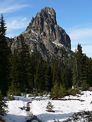
The standard route to the summit starts at Salmon La Sac, passes Cathedral RockCathedral Rock
Cathedral Rock is a famous landmark on the Sedona, Arizona skyline, and is one of the most-photographed sights in Arizona, USA. Cathedral Rock is located in the Coconino National Forest in Yavapai County, about a mile west of Arizona Route 179, and about south of the "Y" intersection of Routes...
(shown right), Peggys Pond, and then is a scramble up to summit.