

Mostarska Petlja
Encyclopedia
Belgrade
Belgrade is the capital and largest city of Serbia. It is located at the confluence of the Sava and Danube rivers, where the Pannonian Plain meets the Balkans. According to official results of Census 2011, the city has a population of 1,639,121. It is one of the 15 largest cities in Europe...
, the capital of Serbia
Serbia
Serbia , officially the Republic of Serbia , is a landlocked country located at the crossroads of Central and Southeast Europe, covering the southern part of the Carpathian basin and the central part of the Balkans...
. It is located in Belgrade's municipality of Savski Venac
Savski Venac
Savski Venac is one of 17 urban municipalities which constitute the City of Belgrade, the capital of Serbia. Savski Venac is one of the three municipalities that constitute the very center of the city .-Location:Savski Venac is located on the right bank of the Sava river...
.
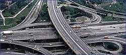
The Mostar looped interchange was constructed in 1974, as one of two major ones (the other one being Autokomanda
Autokomanda
Autokomanda is an urban neighborhood of Belgrade, the capital of Serbia. It is located on the tripoint of the Belgrade's municipalities of Voždovac, Savski Venac and Vračar.- Location :...
) on the highway Belgrade–Niš. The highway runs right through the urban center of Belgrade, which is still an issue of debate even though the road was originally intended as a fast, intercity Bežanija
Bežanija
Bežanija is an urban neighborhood of Belgrade, the capital of Serbia. It is located in Belgrade's municipality of Novi Beograd.- Location :...
-Autokomanda freeway. The interchange itself was built on the location of the old neighborhood of Jatagan Mala
Jatagan Mala
Jatagan Mala is the former urban neighborhood of Belgrade, the capital of Serbia. It was located in Belgrade's municipality of Savski Venac.- Location :...
. Construction began in 1967 and some technical specifications of the interchange include:
- It covers an area of 20,000 square meters
- It has an elevation of 22 meters
- It's crossed by double tramTramA tram is a passenger rail vehicle which runs on tracks along public urban streets and also sometimes on separate rights of way. It may also run between cities and/or towns , and/or partially grade separated even in the cities...
tracks - It has 6 underground pedestrian passages and 4 passarellas, leading to 4 bus and 2 tram stops
- A curiosity factor is that it is one of the very few interchanges downtown.
Due to its construction, Mostar incidentally serves as a water collector so during the major rains it gets regularly flooded by the pond created by the rainwater.
A bitter dispute between the mayor of Belgrade, Nenad Bogdanović
Nenad Bogdanovic
Nenad Bogdanović was the mayor of Belgrade, elected to office in October 2004.-Education and career:...
and a group of architects from the previous city's establishment (including the construction of Mostar and Auto Komanda) resulted in mayor's description of the interchanges from October 2006: 'Those are the two worst interchanges and the only ones in the world with traffic light
Traffic light
Traffic lights, which may also be known as stoplights, traffic lamps, traffic signals, signal lights, robots or semaphore, are signalling devices positioned at road intersections, pedestrian crossings and other locations to control competing flows of traffic...
s...people who made those are today criticizing us.'
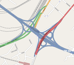
The surrounding neighborhood is entirely non-residential. The northern side is occupied by the buildings of the Ministry of the Interior (destroyed in the 1999 NATO bombing of Serbia) and the Clinical Center, which is the largest clinical complex in Belgrade. The southern side comprises the 'BIP' brewery, Prokop
Prokop (Belgrade)
The Prokop railway station or Belgrade [Centre] railway station is the new railway station as the core of the massive reconstruction of the Belgrade railway junction in Belgrade, the capital of Serbia that officially started 1974...
train station, a series of half-ruined storages and former factories (which should be replaced by new ones beginning in 2008) and the facilities of the Belgrade Fair
Belgrade Fair
The Belgrade Fair or Beogradski Sajam is a large complex of three large domes and dozens of smaller halls which are the location of the major trade fair, the capital city of Serbia. It is located in the municipality of Savski Venac, on the bank of the Sava river...
. To the west it continues into the Belgrade-Niš highway and to the east to the Novi Beograd
Novi Beograd
Novi Beograd or New Belgrade is the most populous municipality that constitutes the City of Belgrade, the capital of Serbia. It is a planned city, built in 1947 on the left bank of the Sava river which was previously an uninhabited area, opposite of the old Belgrade...
and further to Belgrade-Zagreb
Zagreb
Zagreb is the capital and the largest city of the Republic of Croatia. It is in the northwest of the country, along the Sava river, at the southern slopes of the Medvednica mountain. Zagreb lies at an elevation of approximately above sea level. According to the last official census, Zagreb's city...
highway (over the Gazela bridge
Gazela Bridge
Gazela is the most important bridge in Belgrade, Serbia, across the Sava river. It is a part of the city highway and it lies on European route E75, on the highway passing through the wider city center, connecting Belgrade with Niš to the south, and Novi Sad to the north...
).