Moss Landing Wildlife Area
Encyclopedia

California
California is a state located on the West Coast of the United States. It is by far the most populous U.S. state, and the third-largest by land area...
State wildlife preserve on the shore of Elkhorn Slough
Elkhorn Slough
Elkhorn Slough is a tidal slough and estuary on Monterey Bay in Monterey County, California. The community of Moss Landing and the huge Moss Landing Power Plant are located at the mouth of the slough on the bay....
.
Description
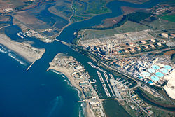
The Moss Landing Wildlife Area protects 728 acres (294.6 ha) of Monterey County, CaliforniaMonterey County, California
Monterey County is a county located on the Pacific coast of the U.S. state of California, its northwestern section forming the southern half of Monterey Bay. The northern half of the bay is in Santa Cruz County. As of 2010, the population was 415,057. The county seat and largest city is Salinas...
, just north of the town of Moss Landing, California
Moss Landing, California
Moss Landing is a census-designated place in Monterey County, California, United States. Moss Landing is located on the Pajaro Valley Consolidated Railroad north-northeast of Monterey, at an elevation of 10 feet . As of the 2010 census, the CDP population was 204, down from 300 at the 2000...
. It includes part of the largest unaltered salt marsh
Salt marsh
A salt marsh is an environment in the upper coastal intertidal zone between land and salt water or brackish water, it is dominated by dense stands of halophytic plants such as herbs, grasses, or low shrubs. These plants are terrestrial in origin and are essential to the stability of the salt marsh...
on the California coast. Access is allowed only by foot on trails, and all plants and animals are protected. It is a popular spot for birding and viewing sea otter
Sea Otter
The sea otter is a marine mammal native to the coasts of the northern and eastern North Pacific Ocean. Adult sea otters typically weigh between 14 and 45 kg , making them the heaviest members of the weasel family, but among the smallest marine mammals...
s.
Some limited hunting is allowed during certain limited seasons, but rifles or pistols are not allowed. It is administered through the California Department of Fish and Game
California Department of Fish and Game
The California Department of Fish and Game is a department within the government of California, falling under its parent California Natural Resources Agency. The Department of Fish and Game manages and protects the state's diverse fish, wildlife, plant resources, and native habitats...
.
A small strip of the reserve (the easiest to access) lies just east of Highway 1
California State Route 1
State Route 1 , more often called Highway 1, is a state highway that runs along much of the Pacific coast of the U.S. state of California. It is famous for running along some of the most beautiful coastlines in the world, leading to its designation as an All-American Road.Highway 1 does not run...
(called the Cabrillo Highway) at 36°48′44"N 121°47′5"W opposite the Moss Landing Yacht Harbor.
Other sections lie north of Elkhorn Slough
Elkhorn Slough
Elkhorn Slough is a tidal slough and estuary on Monterey Bay in Monterey County, California. The community of Moss Landing and the huge Moss Landing Power Plant are located at the mouth of the slough on the bay....
, and west of the slough after it turns to the north, at 36°51′3"N 121°45′49"W.
To access the north shore section, a trailhead is off Highway 1 between the two intersections of Struve Road, at 36°49′41"N 121°46′21"W. A level Marsh Trail runs from this area to a small picnic area, and then the main channel of Elkhorn Slough.
The eastern shore of Elkhorn Slough is protected as part of the Elkhorn Slough National Estuarine Research Reserve
Elkhorn Slough National Estuarine Research Reserve
The Elkhorn Slough National Estuarine Research Reserve is one of 28 National Estuarine Research Reserves established nationwide as field laboratories for scientific research and estuarine education. The Slough is located approximately south of San Francisco, California on the central shore of...
.
Moss Landing State Beach
Moss Landing State Beach
Moss Landing State Beach is a beach in Monterey County, California.-Description:The beach is about north of the city of Monterey via Highway 1 at , about south of Watsonville. Among the most popular activities are offshore fishing, surfing, windsurfing and horseback riding. However, the strong...
and Zmudowski State Beach
Zmudowski State Beach
Zmudowski State Beach is a beach near Moss Landing in Monterey County, California, United States, operated by the California Department of Parks and Recreation. It is a popular fishing area, featuring perch, kingfish, sole, flounder, halibut, bocaccio , jacksmelt, lingcod, cabezon, salmon,...
provide access to the Monterey Bay
Monterey Bay
Monterey Bay is a bay of the Pacific Ocean, along the central coast of California. The bay is south of San Francisco and San Jose, between the cities of Santa Cruz and Monterey....
directly west of the wildlife area.
History

Salt evaporation pond
Salt evaporation ponds, also called salterns or salt pans, are shallow artificial ponds designed to produce salts from sea water or other brines. The seawater or brine is fed into large ponds and water is drawn out through natural evaporation which allows the salt to be subsequently harvested...
s used to commercially produce sea salt
Sea salt
Sea salt, salt obtained by the evaporation of seawater, is used in cooking and cosmetics. It is historically called bay salt or solar salt...
for use in local fish canneries. Owned by the Monterey Bay Salt Company, the ponds were abandoned in 1974.
The wildlife area was established by the state of California in 1984, and was managed in cooperation with the Monterey Bay National Marine Sanctuary
Monterey Bay National Marine Sanctuary
The Monterey Bay National Marine Sanctuary is a US Federally protected marine area offshore of California's central coast around Monterey Bay....
when it was established in 1992.
The former salt ponds provide habitat for several shorebird species.
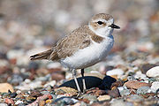
The number of Western Snowy plover
Snowy Plover
The Snowy Plover is a small wader in the plover bird family. It breeds in Ecuador, Peru, Chile, the southern and western USA and the Caribbean...
s (Charadrius alexandrinus nivosus) nesting in the ponds in spring improved after active management began in 1995 by the Point Reyes Bird Observatory Conservation Science
PRBO Conservation Science
PRBO Conservation Science, founded as the Point Reyes Bird Observatory, is a California based wildlife conservation and research non-profit organization...
group.
In 1999 the ponds were identified as the most critical breeding habitat in the Monterey Bay region for the plovers.
In 2006 a managed tidal flow was improved, funded by Ducks Unlimited
Ducks Unlimited
Ducks Unlimited is an international non-profit organization dedicated to the conservation of wetlands and associated upland habitats for waterfowl, other wildlife, and people. It currently has approximately 780,000 members, mostly in the United States and Canada.-Introduction:Ducks Unlimited was...
, the California Wildlife Conservation Board and the National Fish and Wildlife Foundation
National Fish and Wildlife Foundation
The National Fish and Wildlife Foundation protects, sustains and restores the wildlife, plants and habitats of the United States. Established by Congress in 1984, the Foundation directs public conservation dollars to critical environmental needs and matches those investments with private...
.
In late fall water levels are raised to encourage roosting brown pelican
Brown Pelican
The Brown Pelican is the smallest of the eight species of pelican, although it is a large bird in nearly every other regard. It is in length, weighs from and has a wingspan from .-Range and habits:...
s.
In early spring (March of April) the ponds are drained and before the mud dries, volunteers are organized into a "mudstomp" to create shallow impressions as nesting sites.
Binoculars
Binoculars
Binoculars, field glasses or binocular telescopes are a pair of identical or mirror-symmetrical telescopes mounted side-by-side and aligned to point accurately in the same direction, allowing the viewer to use both eyes when viewing distant objects...
, telescopes, or cameras with telephoto lenses are best used for viewing since observers are restricted from getting too close.
Heron
Heron
The herons are long-legged freshwater and coastal birds in the family Ardeidae. There are 64 recognised species in this family. Some are called "egrets" or "bitterns" instead of "heron"....
s, Sandpipers, Egret
Egret
An egret is any of several herons, most of which are white or buff, and several of which develop fine plumes during the breeding season. Many egrets are members of the genera Egretta or Ardea which contain other species named as herons rather than egrets...
s and other waterbirds also are seen in season.
The northern entrance and trails can often be closed to public access.

