

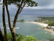
Morro de São Paulo
Encyclopedia
Island
An island or isle is any piece of sub-continental land that is surrounded by water. Very small islands such as emergent land features on atolls can be called islets, cays or keys. An island in a river or lake may be called an eyot , or holm...
Tinharé in Bahia
Bahia
Bahia is one of the 26 states of Brazil, and is located in the northeastern part of the country on the Atlantic coast. It is the fourth most populous Brazilian state after São Paulo, Minas Gerais and Rio de Janeiro, and the fifth-largest in size...
, Brazil
Brazil
Brazil , officially the Federative Republic of Brazil , is the largest country in South America. It is the world's fifth largest country, both by geographical area and by population with over 192 million people...
, 272 km from the city of Salvador
Salvador, Bahia
Salvador is the largest city on the northeast coast of Brazil and the capital of the Northeastern Brazilian state of Bahia. Salvador is also known as Brazil's capital of happiness due to its easygoing population and countless popular outdoor parties, including its street carnival. The first...
by route and 60 km by sea. As part of the municipality of Cairu (only archipelago municipality in Brazi), the way to go to the island is by boat or by regular flights that go from the airport of Salvador
Deputado Luís Eduardo Magalhães International Airport
Salvador-Deputado Luís Eduardo Magalhães International Airport , formerly called Dois de Julho International Airport is the airport serving Salvador da Bahia, Brazil...
to the local airstrip.
Cars are forbidden on Morro de São Paulo. The only method of motorized transportation on the island is by tractor, which carries passengers to other distant beaches, to pousadas (small hotels) on Third, Fourth and Second Beach (the closest to the village) and to the airport.
History
Martim Afonso of Sousa, landed in 1531 and baptized this island “Tynharéa” and the Bahian accent soon transformed that name to “Tinharé”.Tinharé Island is situated to the north of the Camamu Bay archipelago, South of Bahia, a region known as Tabuleiro Valenciano or better still, the Coast of Dendê. Due to its distinct geographical location, the island was subject to innumerable attacks by French and Dutch ships, a true free land for pirates during the colonial period.
Under the jurisdiction of São Jorge dos Ilhéus, the land was given to Jorge de Figueiredo Correa by D.João III, and assigned to Francisco Romero for settlement. The constant attacks of the Aymoré Indians and Tupiniquins against the local regional population helped to quickly populate the islands, and in 1535 Morro de São Paulo village was born on the north side of the island.
Morro de São Paulo protected the so called "barra falsa da Baía de Todos os Santos", strategic entrance to the Itaparica Channel and to the Santo Antônio Fortress (currently named Farol da Barra). Additionally, the Tinharé Channel was essential for delivery of supplies from major production centers to the capital, Salvador. The geographical importance of the island during the colonial period justifies the richness of historical monuments, today protected by the National Historical Patrimony.
Chronology
1531 Martim Afonso of Sousa lands in the Tinharé Island, which eventually becomes part of the Captaincy of São Jorge dos Ilhéus. D.João III donates the land to Jorge of Figueiredo Correa, who begins settlement.1535 Francisco Romero and the local population found Morro de São Paulo village, located on the extreme north part of the island.
1624 Commander Johan Van Dortt and his squad land on the island during their route to Salvador.
1628 The Dutch Almirant Pieterzoon Hiyn leads an attack and loots the village.
1630 Governor Diogo Luiz of Oliveira initiates construction of the Fortress.
1728 Completion of the Forte da Ponta Fortress and wall along the island. Defeat of the French Admiral Villegaignon by Portuguese troops.
1746 Construction of Fonte Grande, the largest water supply system of colonial Bahia.
1845 Conclusion of the Church and Santo Antônio Convent, the N. Sra da Luz Chapel.
1855 Engineer Carson finalizes the construction of the lighthouse.
1859 The Royal Family and D. Pedro II. visit the island.
First Beach
The first summer houses were built on this beach. Today most of them have become "pousadas"/inns, stores or restaurants, and the few that remain are rented to tourists throughout the year. Similar to the houses converted into "pousadas", the old beach kiosks, almost all owned by local families. The first beach is also known for marine attractions and also serves as the landing area for the tirolesa, or zipline, from the lighthouse.Second Beach
This beach is well known especially among young people. The beach forms the stage for "rodas de capoeira" at the end of the day.Third Beach
This beach is special due to Caitá Island, formed by a large barrier of coral reefCoral reef
Coral reefs are underwater structures made from calcium carbonate secreted by corals. Coral reefs are colonies of tiny living animals found in marine waters that contain few nutrients. Most coral reefs are built from stony corals, which in turn consist of polyps that cluster in groups. The polyps...
s. The underwater view offers coral and fish of all colors and shapes. It's possible to rent all necessary equipment. Group boat trips can be arranged as well. This beach also offers several accommodation options: tents, inns, restaurants and campsites.
Fourth Beach
At first sight, Fourth Beach appears to have no end. A great barrier of coral forms innumerable natural swimming pools along this beach.Following Fourth Beach, the first entrance goes to Zimbo, a small village. Entering Zimbo, there are several trails that lead to the village of Gamboa, or to the mount [hill] of Mangaba.
Encanto Beach
Walking a little further, after crossing a mangrove swamp and a small river, is the Fifth Beach or Beach of Enchantment. Until recently, it was still considered part of Fourth beach, as well as all of the extension of beach to the source of the river that separates the island of Tinharé from the island of Boipeba. Before arriving to Boipeba, there is the small village of Garapuá, a fishing town.Garapua
Along the way to the small neighboring island of Boipeba, there is the small fishing village with calm, crystalline waters. There are a few simple pousadas here.Boipeba
The small island of Tinharé is separated by Rio do Inferno (Hell River). From Morro de São Paulo, tractors and small watercraft leave daily to bring travelers to this island.Ponta da Pedra ("Tip of the Rock")
This beach provides access to the town of Gamboa. It is almost a 30 minute walk from the dock of Morro de São Paulo to the dock of Gamboa.This area is called Tip of the Rock or beach of Gamboa by its inhabitants. The beaches are surrounded by rocks and transparent calm waters. There's a local yacht club, where sailboats are anchored.
A little ahead there is a clay erosion area.
Gamboa Beach
After a 20 minute walk along the beach of the Tip of the Rock, there is the town of the Gamboa. Gamboa, until recent years seemed to be kilometers away from Morro de São Paulo, for there was no sign of the tourism development that was bustling in Morro de São Paulo. It has continued being a peaceful fishing village. Perhaps this is the reason why some inhabitants have moved here and built houses and inns. However, although the infrastructure has developed somewhat, with good "pousadas" (inns) and restaurants and regional cuisine, the peaceful atmosphere of this fishing town is still preserved.In Gamboa, the waters are calm and crystalline and the beach serene, with few people moving about. The majority of the island locals live in Gamboa.
Fort Beach
The Fortress Beach, reveals a strip of sand next to the natural swimming pools where it is possible to dive or snorkel.External links
- Morro de São Paulo Photos from Morro de São Paulo