

Milton Keynes urban area
Encyclopedia
Milton Keynes
Milton Keynes , sometimes abbreviated MK, is a large town in Buckinghamshire, in the south east of England, about north-west of London. It is the administrative centre of the Borough of Milton Keynes...
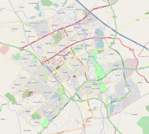
is a large town in (ceremonial) Buckinghamshire. The Milton Keynes urban area is a designation established by the United Kingdom's Office of National Statistics. As with other urban areas, it includes settlements that regard themselves as being outside Milton Keynes. However, unlike other long established towns and cities that have historic boundaries which the ONS can use, Milton Keynes does not have any such readily usable boundaries and consequently it is assigned a number of new urban sub-areas. Accordingly, it has defined a Milton Keynes urban area to be composed of the contiguous built environment, with 'urban sub-areas' that map to the original urban and rural districts (and sometimes to the chronological phases of urbanisation within them).
Urban sub-areas
Some of the "Urban Sub-areas" largely match the boundaries of the legacy local government areas that existed before its 1967 designationHistory of Milton Keynes
Milton Keynes is a large town in South East England, founded in 1967. This history of Milton Keynes details its development from the earliest human settlements, through the plans for a 'new city' for 250,000 people in south central England, its subsequent urban design and development, to the...
as a "new town". These were:
- Bletchley Urban DistrictBletchley Urban DistrictFenny Stratford Urban District was from 1895 to 1911 the name of a local government authority in the administrative county of Buckinghamshire, England. In 1911 the urban district was renamed Bletchley Urban District....
- Wolverton Urban DistrictWolverton Urban DistrictStratford and Wolverton Rural District , Stratford and Wolverton Urban District and Wolverton Urban District were local government districts in Buckinghamshire, England, covering the town of Wolverton and its environs.It was created as a rural district in 1894 and took over the responsibility for...
- Newport Pagnell Urban DistrictNewport Pagnell Urban DistrictNewport Pagnell Urban District was a local government authority in the administrative county of Buckinghamshire, England, from 1897 to 1974....
- Newport Pagnell Rural DistrictNewport Pagnell Rural DistrictNewport Pagnell was a rural district in the administrative county of Buckinghamshire, England, from 1894 to 1974. The rural district took over the responsibilities of the disbanded Newport Pagnell Rural Sanitary District...
- Winslow Rural DistrictWinslow Rural DistrictWinslow was a rural district in the administrative county of Buckinghamshire, England from 1894 to 1974. The rural district took over the responsibilities of the disbanded Winslow Rural Sanitary District...
The corresponding modern Urban Sub-areas (with links to the relevant articles) are
- Bletchley USa
- Wolverton/Stony Stratford USa
- Newport Pagnell USa (but note that the M1 Motorway does not follow the historic boundary).
Newport Pagnell Rural was subdivided as development proceeded
- Central Milton Keynes USa
- North Milton Keynes USaNorth Milton KeynesNorth Milton Keynes is an Office of National Statistics designated urban sub-area .The Central Milton Keynes urban sub-area and the North Milton Keynes urban sub-area together approximate to that part of the former Newport Pagnell Rural District that is west of the River Ouzel.The provenance of...
, - Walnut Tree USa and
- Browns Wood USa
The fragment of Winslow Rural in the designated area, Shenley Church End
Shenley Church End
Shenley Church End is a village, district and civil parish in Milton Keynes England. Together with its neighbouring parish, Shenley Brook End and the districts of Shenley Wood and Shenley Lodge, the districts are collectively known as "The Shenleys".-History:...
, was added to "Central Milton Keynes USa").
Note that the areas covered by these Urban Sub-area designations are larger (sometimes far larger) than the modern districts that share their names. This is particularly true of Central Milton Keynes USa.
The Milton Keynes urban boundary
Although Milton Keynes does not have statutory boundary, the 1967 "Designated Area" boundary (plus subsequent expansions west of the M1) is treated as the de-facto boundary. This contains the ONS Urban Sub-areas of Bletchley, Wolverton/Stony Stratford, Central Milton Keynes, North Milton Keynes, Walnut Tree and Browns Wood. It excludes Newport Pagnell or other expansions east of the M1.Calculation of population
The Office of National Statistics gives the population of Milton Keynes as the entire urban area thus including Newport Pagnell as 184,506.The Borough of Milton Keynes
Milton Keynes (borough)
The Borough of Milton Keynes is a unitary authority and borough in south central England, at the northern tip of the South East England Region. For ceremonial purposes, it is in the county of Buckinghamshire...
calculates the population as being the sum of those urban sub-areas within the 1967 designation, resulting in a figure of 169,486.