

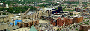
Mills District, Minneapolis
Encyclopedia
Minnesota
Minnesota is a U.S. state located in the Midwestern United States. The twelfth largest state of the U.S., it is the twenty-first most populous, with 5.3 million residents. Minnesota was carved out of the eastern half of the Minnesota Territory and admitted to the Union as the thirty-second state...
, United States
United States
The United States of America is a federal constitutional republic comprising fifty states and a federal district...
, and a part of the larger Downtown East
Downtown East, Minneapolis
Downtown East is an official neighborhood in Minneapolis, Minnesota, United States part of the larger Central community. Its boundaries are the Mississippi River to the north, Interstate 35W to the east, 5th Street South to the south, and Portland Avenue to the west. It is bounded by the Downtown...
neighborhood. Its approximate boundaries are the Mississippi River
Mississippi River
The Mississippi River is the largest river system in North America. Flowing entirely in the United States, this river rises in western Minnesota and meanders slowly southwards for to the Mississippi River Delta at the Gulf of Mexico. With its many tributaries, the Mississippi's watershed drains...
to the north, the I-35W Mississippi River Bridge to the east, Washington Avenue
Washington Avenue (Minneapolis)
Washington Avenue is a major thoroughfare in Minneapolis, Minnesota. Starting north of Lowry Avenue, the street runs straight south, with Interstate 94 running alongside it until just south of West Broadway, when the freeway turns to the west...
to the south, and 5th Avenue to the west. It is bounded by Downtown West
Downtown West, Minneapolis
Downtown West is an official neighborhood in Minneapolis, part of the larger Central community. It is the heart of downtown Minneapolis , containing the bulk of high-rise office buildings in the city, and is what comes to mind when most Minneapolitans think of "downtown"...
as well as the rest of the Downtown East neighborhoods. The Marcy-Holmes neighborhood is on the other side of the river, but there is no direct automobile connection between the two neighborhoods. There is a pedestrian and bicycle connection via the Stone Arch Bridge.
The neighborhood contains a number of former flour mills left over from the days when Minneapolis was the flour milling capital of the world; a number of these have been converted into condominiums. The area also includes several cultural institutions, including the Guthrie Theater
Guthrie Theater
The Guthrie Theater is a center for theater performance, production, education, and professional training in Minneapolis, Minnesota. It is the result of the desire of Sir Tyrone Guthrie, Oliver Rea, and Peter Zeisler to create a resident acting company that would produce and perform the classics in...
, the Mill City Museum
Mill City Museum
Mill City Museum is a Minnesota Historical Society museum in Minneapolis. It opened in 2003, built in the ruins of the Washburn "A" Mill next to Mill Ruins Park on the banks of the Mississippi River...
as well as the MacPhail Center for Music
MacPhail Center for Music
The MacPhail Center for Music is a nonprofit music school in a recently opened building in the Mills District of Downtown East, Minneapolis, Minnesota. The school has over 7,750 students, providing instruction at 48 locations outside of its downtown Minneapolis facility on more than 35 instruments...
. The area includes Mill Ruins Park
Mill Ruins Park
Mill Ruins Park is a park in downtown Minneapolis, Minnesota, United States, standing on the west side of Saint Anthony Falls on the Mississippi River. The park interprets the history of flour milling in Minneapolis and shows the ruins of several flour mills that were abandoned.The park is the...
as well as the new Gold Medal Park
Gold Medal Park
Gold Medal Park is a park next to the Guthrie Theater in Minneapolis, Minnesota, USA. Designed by landscape architect Tom Oslund, the park is owned by the city of Minneapolis and opened in May 2007. It takes its inspiration from the Dakota Indians burial mounds that are found through Minnesota...
. It contains the headquarters for the McKnight Foundation
McKnight Foundation
The McKnight Foundation is a philanthropic organization based in Minneapolis, Minnesota in the United States. The foundation's interests lie in the environment, the arts, community development, and other areas....
as well as Walden University
Walden University
Walden University is a private, for-profit, specialized distance learning institution of higher education. Headquartered in the Mills District in Minneapolis, Minnesota, Walden University offers Bachelor of Science, Master of Science, Master of Business Administration, Master of Public...
.
History
Industrial mills began to appear along the Mississippi River near Saint Anthony FallsSaint Anthony Falls
Saint Anthony Falls, or the Falls of Saint Anthony, located northeast of downtown Minneapolis, Minnesota, was the only natural major waterfall on the Upper Mississippi River. The natural falls was replaced by a concrete overflow spillway after it partially collapsed in 1869...
in the early 19th century. Utilizing the natural water power provided by the falls as well as cutting edge technological advances – the area quickly made Minneapolis the milling center of the upper Midwest. Within decades, the riverfront was literally lined with flour mills - including future corporate giants General Mills and Pillsbury. At its zenith, Minneapolis’ Mill District was the largest producer of flour in the world. The Mill District was part of the greater flour milling industry tied around Saint Anthony Falls
Saint Anthony Falls
Saint Anthony Falls, or the Falls of Saint Anthony, located northeast of downtown Minneapolis, Minnesota, was the only natural major waterfall on the Upper Mississippi River. The natural falls was replaced by a concrete overflow spillway after it partially collapsed in 1869...
. With mills stretching from the current Mill District to the other side of the Mississippi to Nicollet Island
Nicollet Island
Nicollet Island is an island in the Mississippi River just north of downtown Minneapolis, Minnesota, named for cartographer, Joseph Nicollet. DeLaSalle High School and the Nicollet Island Inn are located there, as well as three multi-family residential buildings and twenty-two restored...
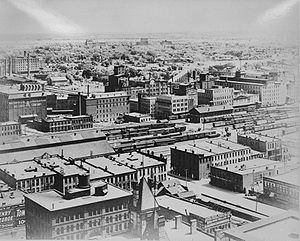
these mills prospered from the late-19th century to the 1930s.
In the late 1930s, as fossil fuels began to replace water power throughout the industry, Minneapolis’ milling business declined and by the 1960s, most of the once-mighty flour mills on the West Bank had ceased production and were demolished or left vacant. The rail lines that had fed the mills were removed and turned into parking lots for the nearby Hubert H. Humphrey Metrodome
Hubert H. Humphrey Metrodome
The Hubert H. Humphrey Metrodome, commonly called the Metrodome, is a domed sports stadium in downtown Minneapolis, Minnesota, United States. Opened in 1982, it replaced Metropolitan Stadium, which was on the current site of the Mall of America in Bloomington and Memorial Stadium on the University...
.
In 1998, the City of Minneapolis enacted a Historic Mills District Master Plan, revised in 2000, to encourage development along the long-neglected stretch of riverfront. As a result, historic buildings were converted for adaptive reuse, bringing a residential population and offices to a neighborhood that beforehand had few residents.
Today, the Mill District has re-emerged as the historical and cultural center of Minneapolis. Many of the original flour mills have been saved and renovated into elegant loft homes and office spaces. The fortified ruins of the Washburn "A" Mill, once the largest mill in the world, has been transformed into the cornerstone of the Mill City Museum
Mill City Museum
Mill City Museum is a Minnesota Historical Society museum in Minneapolis. It opened in 2003, built in the ruins of the Washburn "A" Mill next to Mill Ruins Park on the banks of the Mississippi River...
. Opened in 2003 this National Historic Landmark
National Historic Landmark
A National Historic Landmark is a building, site, structure, object, or district, that is officially recognized by the United States government for its historical significance...
and museum features exhibits, artifacts, an observation deck, and boutique cafe. The renovated Milwaukee Road Depot is “a place for people again” with a popular ice rink in the old train shed. In 2006, the internationally acclaimed Guthrie Theater
Guthrie Theater
The Guthrie Theater is a center for theater performance, production, education, and professional training in Minneapolis, Minnesota. It is the result of the desire of Sir Tyrone Guthrie, Oliver Rea, and Peter Zeisler to create a resident acting company that would produce and perform the classics in...
moved from its previous location near Loring Park
Loring Park
Loring Park is the largest park in the Central Community of Minneapolis, Minnesota on the southwest corner of downtown Minneapolis. It also lends its name to the surrounding neighborhood.- Park :...
. The MacPhail Center for Music
MacPhail Center for Music
The MacPhail Center for Music is a nonprofit music school in a recently opened building in the Mills District of Downtown East, Minneapolis, Minnesota. The school has over 7,750 students, providing instruction at 48 locations outside of its downtown Minneapolis facility on more than 35 instruments...
moved its new campus to the neighborhood in 2007. The Mill City Farmers Market, an organic farmers market, was begun in 2006.