

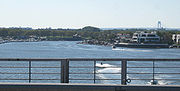
Mill Basin, Brooklyn
Encyclopedia
New York City
New York is the most populous city in the United States and the center of the New York Metropolitan Area, one of the most populous metropolitan areas in the world. New York exerts a significant impact upon global commerce, finance, media, art, fashion, research, technology, education, and...
in the southern portion of the borough
Borough (New York City)
New York City, one of the largest cities in the world, is composed of five boroughs. Each borough now has the same boundaries as the county it is in. County governments were dissolved when the city consolidated in 1898, along with all city, town, and village governments within each county...
of Brooklyn
Brooklyn
Brooklyn is the most populous of New York City's five boroughs, with nearly 2.6 million residents, and the second-largest in area. Since 1896, Brooklyn has had the same boundaries as Kings County, which is now the most populous county in New York State and the second-most densely populated...
lying along Jamaica Bay
Jamaica Bay
Jamaica Bay is located on the southwestern tip of Long Island in the boroughs of Brooklyn and Queens, New York City, and the town of Hempstead, New York/hamlet of Inwood...
and bounded to the north by Avenue U, and to the east, south, and west by the Mill Basin/Mill Island Inlet. The area is part of Brooklyn Community Board 18
Brooklyn Community Board 18
Brooklyn Community Board 18 is a local governmental body in the New York City borough of Brooklyn that encompasses the neighborhoods of Canarsie, Bergen Beach, Mill Basin, Flatlands, Marine Park, Georgetown, and Mill Island...
.
History
The area was called Equandito (Broken Lands) by the local LenapeLenape
The Lenape are an Algonquian group of Native Americans of the Northeastern Woodlands. They are also called Delaware Indians. As a result of the American Revolutionary War and later Indian removals from the eastern United States, today the main groups live in Canada, where they are enrolled in the...
Native Americans who sold it in 1664 to John Tilton Jr. and Samuel Spicer. During the seventeenth century it became part of Flatlands
Flatlands, Brooklyn
Flatlands is a neighborhood in the New York City borough of Brooklyn. The area is part of Brooklyn Community Board 18.One of the original five Dutch towns on Long Island , this neighborhood was originally known as Nieuw Amersfoort, after the Dutch city of Amersfoort, but the name was changed to...
, and tide mill
Tide mill
A tide mill is a water mill driven by tidal rise and fall. A dam with a sluice is created across a suitable tidal inlet, or a section of river estuary is made into a reservoir. As the tide comes in, it enters the mill pond through a one way gate, and this gate closes automatically when the tide...
s were built on it; the land was owned from 1675 by Jan Martense Schenck and between 1818 and 1870 by the wife of General Philip S. Crooke
Philip S. Crooke
Philip Schuyler Crooke was a United States Representative from New York.Born in Poughkeepsie, he graduated from Dutchess Academy, studied law, was admitted to the bar in 1831 and commenced practice in Brooklyn...
. The Crooke-Schenck House
Jans Martense Schenck house
Jan Martense Schenck, arrived in New Netherlands on June 28, 1650, on the ship De Valckener with his sister Annetje and brother Roelof. He bought a parcel of land on Molen Eylandt in the Dutch town of Nieuw Amersfoort in what is now the Mill Basin section of Brooklyn, New York...
, which stood at East 63rd Street, was dismantled in 1952 and later reassembled as a museum exhibit at the Brooklyn Museum
Brooklyn Museum
The Brooklyn Museum is an encyclopedia art museum located in the New York City borough of Brooklyn. At 560,000 square feet, the museum holds New York City's second largest art collection with roughly 1.5 million works....
. The area retained its rural character until Robert L. Crooke built a lead-smelting plant in 1890. The Crooke Smelting Company was bought out by the National Lead Company, and Crooke sold the remainder of the land to the firm of McNulty and Fitzgerald, which erected bulkheads and filled in the marshes.
Until the early twentieth century, the chief resources were the abundant crabs, oysters, and clams in Jamaica Bay. In 1906 the Flatbush Improvement Company brought marshland and engaged the firm of Atlantic, Gulf and Pacific to dredge creeks and fill in meadows. Eventually the parcel had an area of 332 acres (1.3 km²) and was fit for industrial development, and within a decade National Lead, Gulf Refining, and other leading firms engaged in heavy industry opened plants there. Atlantic, Gulf and Pacific bought the land in 1909 and built three large drydocks employing a thousand workers; it also began promoting Jamaica Bay
Jamaica Bay
Jamaica Bay is located on the southwestern tip of Long Island in the boroughs of Brooklyn and Queens, New York City, and the town of Hempstead, New York/hamlet of Inwood...
as a major harbor but failed to attract a large volume of shipping. A project begun in 1913 and completed in 1923 to extend Flatbush Avenue
Flatbush Avenue (Brooklyn)
Flatbush Avenue is one of the major avenues in the New York City Borough of Brooklyn. It runs from the Manhattan Bridge south-southeastward to Jamaica Bay, where it joins the Marine Parkway Bridge, which connects Brooklyn to the Rockaway Peninsula in Queens...
to the Rockaway Inlet
Rockaway Inlet
Rockaway Inlet is a strait connecting Jamaica Bay, wholly within New York City, with the Atlantic Ocean. It separates the Rockaway Peninsula in Queens from the Floyd Bennett Field in Brooklyn....
provided an additional 2700 feet (823 m) of dock facilities and a strip of land for a road across the marshes. In 1915 a channel was dredged to the main channel of Jamaica Bay, and a bulkhead and wharfage platform were built on the mainland side of Mill Creek. By 1919, Mill Island was the site of at least six manufacturing and commercial concerns. During the late 1920s and 1930s the docks were rented to a number of small industrial firms. The neighborhood remained a grimy industrial area for thirty years, but its further development was hindered when plans for rail service to the rest of Brooklyn went unrealized.
Residential development began after World War II
World War II
World War II, or the Second World War , was a global conflict lasting from 1939 to 1945, involving most of the world's nations—including all of the great powers—eventually forming two opposing military alliances: the Allies and the Axis...
, when Atlantic, Gulf and Pacific sold to the firm of Flatbush Park Homes the land bounded to the north by Avenue U, to the east by East 68th Street and East Mill Basin / Mill Island, to the south by Basset Avenue, and to the west by Strickland Avenue and Mill Avenue. Brick bungalows were built in the late 1940s and early 1950s, many of which were later replaced by large, custom-built, detached one-family houses on lots measuring fifty by a hundred feet.
Mill Basin Drawbridge
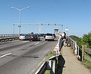
Bascule bridge
A bascule bridge is a moveable bridge with a counterweight that continuously balances the span, or "leaf," throughout the entire upward swing in providing clearance for boat traffic....
supporting the Belt Parkway
Belt Parkway
The Belt System is a series of connected limited-access highways that form a belt-like circle around the New York City boroughs of Brooklyn and Queens. The system comprises four officially separate parkways; however, three of the four are signed as the Belt Parkway...
over Mill Basin. Each leaf carries six lanes of traffic - three in each direction. There is a sidewalk on each side of the leaf; the eastern or downstream one being part of the Shore Parkway Greenway.
Built in the 1940s, the bridge, which cost $1.4 million, is the only drawbridge
Drawbridge
A drawbridge is a type of movable bridge typically associated with the entrance of a castle surrounded by a moat. The term is often used to describe all different types of movable bridges, like bascule bridges and lift bridges.-Castle drawbridges:...
on the Belt Parkway.
Reconstruction
The New York City Department of Transportation reconstructed the Belt Parkway Bridge over Mill Basin in late 2006. The bridge was constructed in 1942 and has outlived its useful service life. Due to the effects of age, weather and increased traffic volume, reconstruction was deemed necessary. The reconstruction work was accomplished in 2 stages.
Transportation
Mill Basin is served by the B100 local bus and BM1 express bus on East 66th Street.It also has B3 local and B47 local
External links
- Mill Basin Memories: A site for displaced Brooklynites from the Mill Basin and surrounding areas looking to reconnect with old friends, reminisce and rediscover their Brooklyn roots. Features forums, photos, and more.
- New York Times, May 1 2009 Real Estate section: General picture of Mill Basin.
- The Unofficial Mill Basin and Brooklyn Webpage L Long running, well established site with messageboards and guestbooks for Mill Basin and the area schools.
- Demographics.aspx Mill Basin Demographics
- Mill’s Long Gone, but the Basin’s Still Full NY Times 2009 May 3