Michelmersh
Encyclopedia
Michelmersh is a small, scattered village in Hampshire
, England
some three miles north of Romsey
.
It forms a civil parish
with Timsbury that forms part of the Test Valley
district.
The Monarch's Way
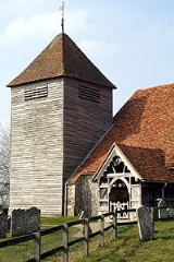
long-distance footpath crosses the parish, passing through the churchyard of the 12th century St Mary's Church.
The parish is located to the east of the River Test
on the northern edge of the Hampshire Basin
, with chalk
in the north overlain by clays and sands of the Lambeth Group
to the south. It has a brick and tile works, and extensive former sand pits on Casbrook Common, now used as a landfill
site.
The name Michelmersh is derived from the Old English micel + mersc, meaning ' large marsh'.
Hampshire
Hampshire is a county on the southern coast of England in the United Kingdom. The county town of Hampshire is Winchester, a historic cathedral city that was once the capital of England. Hampshire is notable for housing the original birthplaces of the Royal Navy, British Army, and Royal Air Force...
, England
England
England is a country that is part of the United Kingdom. It shares land borders with Scotland to the north and Wales to the west; the Irish Sea is to the north west, the Celtic Sea to the south west, with the North Sea to the east and the English Channel to the south separating it from continental...
some three miles north of Romsey
Romsey
Romsey is a small market town in the county of Hampshire, England.It is 8 miles northwest of Southampton and 11 miles southwest of Winchester, neighbouring the village of North Baddesley...
.
It forms a civil parish
Civil parish
In England, a civil parish is a territorial designation and, where they are found, the lowest tier of local government below districts and counties...
with Timsbury that forms part of the Test Valley
Test Valley
Test Valley is a local government district and borough in Hampshire, England, named after the valley of the River Test. Its council is based in Andover....
district.
The Monarch's Way
Monarch's Way
The Monarch's Way is a long-distance footpath in England that approximates the escape route taken by King Charles II in 1651 after being defeated in the Battle of Worcester.Most of the footpath is waymarked...
long-distance footpath crosses the parish, passing through the churchyard of the 12th century St Mary's Church.
The parish is located to the east of the River Test
River Test
The River Test is a river in Hampshire, England. The river has a total length of 40 miles and it flows through downland from its source near Ashe, 10 km to the west of Basingstoke , to the sea at the head of Southampton Water...
on the northern edge of the Hampshire Basin
Hampshire Basin
The Hampshire Basin is a geological basin of Paleogene age in southern England, underlying parts of Hampshire, the Isle of Wight, Dorset, and Sussex...
, with chalk
Chalk
Chalk is a soft, white, porous sedimentary rock, a form of limestone composed of the mineral calcite. Calcite is calcium carbonate or CaCO3. It forms under reasonably deep marine conditions from the gradual accumulation of minute calcite plates shed from micro-organisms called coccolithophores....
in the north overlain by clays and sands of the Lambeth Group
Lambeth Group
The Lambeth Group is a stratigraphic group, a set of geological rock strata in the London and Hampshire Basins of southern England. It comprises a complex of vertically and laterally varying gravels, sands, silts and clays deposited between 56-55 million years before present during the Ypresian age...
to the south. It has a brick and tile works, and extensive former sand pits on Casbrook Common, now used as a landfill
Landfill
A landfill site , is a site for the disposal of waste materials by burial and is the oldest form of waste treatment...
site.
The name Michelmersh is derived from the Old English micel + mersc, meaning ' large marsh'.

