
Metropolitan Borough of Paddington
Encyclopedia
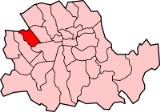
The Metropolitan Borough of Paddington was a Metropolitan borough
of the County of London
between 1900 and 1965.
, and north of Bayswater Road
. Places in the borough included Paddington
, Westbourne Green
, Bayswater
, Maida Hill, West Kilburn, Maida Vale
. To the south it bordered the Metropolitan Borough of Westminster
, to the east, the Metropolitan Borough of St Marylebone
.
The borough was abolished on 1 April 1965 by the London Government Act 1963
and its former area merged with that of the Metropolitan Borough of Westminster
and the Metropolitan Borough of St Marylebone
to form the present-day City of Westminster
.
.jpg) The borough council's coat of arms, granted by the College of Arms
The borough council's coat of arms, granted by the College of Arms
on 5 April 1902, was based on the former Paddington vestry seal. The seal featured crossed swords from the arms of the See of London
passing through a mural crown
, symbol of local government. To these were added the wolves' heads and blue background from the arms of the first Mayor of the Borough, Sir John Aird. Sir John, who was member of parliament
for Paddington North
, also donated the mayoral badge and chain.
The arms were blazon
ed as follows:
. The chair used by the Mayors of Paddington at council meetings was preserved, and is currently placed in the hallway at the Council House in Marylebone Road, the current meeting place for Westminster City Council. The war memorial, unveiled in 1924, was moved to the adjacent parish church of St. Mary.
Civil Parish 1801-1899
Metropolitan Borough 1900-1961
Metropolitan boroughs of the County of London
The term metropolitan borough was used from 1900 to 1965, for the subdivisions of the County of London created by the London Government Act 1899....
of the County of London
County of London
The County of London was a county of England from 1889 to 1965, corresponding to the area known today as Inner London. It was created as part of the general introduction of elected county government in England, by way of the Local Government Act 1888. The Act created an administrative County of...
between 1900 and 1965.
History
Its area covered that part of the current City of Westminster west of Edgware Road and Maida ValeMaida Vale
Maida Vale is a residential district in West London between St John's Wood and Kilburn. It is part of the City of Westminster. The area is mostly residential, and mainly affluent, consisting of many large late Victorian and Edwardian blocks of mansion flats...
, and north of Bayswater Road
Bayswater Road
Bayswater Road is the main road running across the north of Hyde Park, London. To the east Bayswater Road becomes Oxford Street . It is where the fictional upper middle class Forsyte family live in the BBC series the Forsyte Saga...
. Places in the borough included Paddington
Paddington
Paddington is a district within the City of Westminster, in central London, England. Formerly a metropolitan borough, it was integrated with Westminster and Greater London in 1965...
, Westbourne Green
Westbourne Green
Westbourne Green is an area of London on the western edge of the City of Westminster.-Transport and locale:Nearby places*Paddington*Notting Hill*Bayswater*Warwick Avenue...
, Bayswater
Bayswater
Bayswater is an area of west London in the City of Westminster and the Royal Borough of Kensington and Chelsea to the west . It is a built-up district located 3 miles west-north-west of Charing Cross, bordering the north of Hyde Park over Kensington Gardens and having a population density of...
, Maida Hill, West Kilburn, Maida Vale
Maida Vale
Maida Vale is a residential district in West London between St John's Wood and Kilburn. It is part of the City of Westminster. The area is mostly residential, and mainly affluent, consisting of many large late Victorian and Edwardian blocks of mansion flats...
. To the south it bordered the Metropolitan Borough of Westminster
Metropolitan Borough of Westminster
The Metropolitan Borough of Westminster was a metropolitan borough in the County of London, England, from 1900 to 1965.-City Status:By royal charter dated 29 October 1900 the borough was granted the title City of Westminster. Westminster had originally been created a city and seat of the...
, to the east, the Metropolitan Borough of St Marylebone
Metropolitan Borough of St Marylebone
The Metropolitan Borough of St Marylebone was a Metropolitan borough of the County of London from 1900 to 1965. It was based directly on the previously existing civil parish of St Marylebone, which was incorporated into the Metropolitan Board of Works area in 1855, retaining a parish vestry, and...
.
The borough was abolished on 1 April 1965 by the London Government Act 1963
London Government Act 1963
The London Government Act 1963 is an Act of the Parliament of the United Kingdom, which recognised officially the conurbation known as Greater London and created a new local government structure for the capital. The Act significantly reduced the number of local government districts in the area,...
and its former area merged with that of the Metropolitan Borough of Westminster
Metropolitan Borough of Westminster
The Metropolitan Borough of Westminster was a metropolitan borough in the County of London, England, from 1900 to 1965.-City Status:By royal charter dated 29 October 1900 the borough was granted the title City of Westminster. Westminster had originally been created a city and seat of the...
and the Metropolitan Borough of St Marylebone
Metropolitan Borough of St Marylebone
The Metropolitan Borough of St Marylebone was a Metropolitan borough of the County of London from 1900 to 1965. It was based directly on the previously existing civil parish of St Marylebone, which was incorporated into the Metropolitan Board of Works area in 1855, retaining a parish vestry, and...
to form the present-day City of Westminster
City of Westminster
The City of Westminster is a London borough occupying much of the central area of London, England, including most of the West End. It is located to the west of and adjoining the ancient City of London, directly to the east of the Royal Borough of Kensington and Chelsea, and its southern boundary...
.
Coat of arms
College of Arms
The College of Arms, or Heralds’ College, is an office regulating heraldry and granting new armorial bearings for England, Wales and Northern Ireland...
on 5 April 1902, was based on the former Paddington vestry seal. The seal featured crossed swords from the arms of the See of London
Diocese of London
The Anglican Diocese of London forms part of the Province of Canterbury in England.Historically the diocese covered a large area north of the Thames and bordered the dioceses of Norwich and Lincoln to the north and west. The present diocese covers and 17 London boroughs, covering most of Greater...
passing through a mural crown
Mural crown
-Usage in ancient times:In Hellenistic culture, a mural crown identified the goddess Tyche, the embodiment of the fortune of a city, familiar to Romans as Fortuna...
, symbol of local government. To these were added the wolves' heads and blue background from the arms of the first Mayor of the Borough, Sir John Aird. Sir John, who was member of parliament
Member of Parliament
A Member of Parliament is a representative of the voters to a :parliament. In many countries with bicameral parliaments, the term applies specifically to members of the lower house, as upper houses often have a different title, such as senate, and thus also have different titles for its members,...
for Paddington North
Paddington North (UK Parliament constituency)
Paddington North was a borough constituency in the Metropolitan Borough of Paddington in London which returned one Member of Parliament to the House of Commons of the Parliament of the United Kingdom, elected by the first past the post voting system...
, also donated the mayoral badge and chain.
The arms were blazon
Blazon
In heraldry and heraldic vexillology, a blazon is a formal description of a coat of arms, flag or similar emblem, from which the reader can reconstruct the appropriate image...
ed as follows:
Azure, two Swords in Saltire proper pommels and hilts Or enfiled with a Mural Crown of the last. Two Wolves heads erased in Chief Argent.
Town Hall
Paddington Town Hall, designed by James Lockyer in the Classical style, dated from 1853. The building, originally the Vestry Hall, was situated on Paddington Green. It was enlarged in 1900 and 1920. Following its closure in 1965, it was demolished to make way for the Westway urban motorwayWestway (London)
The Westway is a long elevated dual carriageway section of the A40 route in west London running from Paddington to North Kensington. The road was constructed between 1964 and 1970 to relieve congestion at Shepherd's Bush caused by traffic from Western Avenue struggling to enter central London on...
. The chair used by the Mayors of Paddington at council meetings was preserved, and is currently placed in the hallway at the Council House in Marylebone Road, the current meeting place for Westminster City Council. The war memorial, unveiled in 1924, was moved to the adjacent parish church of St. Mary.
Area and population
The area of Paddington Metropolitan Borough was 1357 acres (5.5 km²), once part of Kensal New Town was added after 1901. The population recorded in the Census was:Civil Parish 1801-1899
| Year | 1801 | 1811 | 1821 | 1831 | 1841 | 1851 | 1861 | 1871 | 1881 | 1891 |
|---|---|---|---|---|---|---|---|---|---|---|
| Population | 1,881 | 4,609 | 6,476 | 14,540 | 25,173 | 46,305 | 75,784 | 96,813 | 107,058 | 117,846 |
Metropolitan Borough 1900-1961
| Year | 1901 | 1911 | 1921 | 1931 | 1941 | 1951 | 1961 |
|---|---|---|---|---|---|---|---|
| Population | 143,976 | 142,551 | 144,261 | 144,923 | 125,463 | 116,923 |
- Note that the population statistics up to 1891 exclude the area of Kensal Town transferred from ChelseaChelsea, LondonChelsea is an area of West London, England, bounded to the south by the River Thames, where its frontage runs from Chelsea Bridge along the Chelsea Embankment, Cheyne Walk, Lots Road and Chelsea Harbour. Its eastern boundary was once defined by the River Westbourne, which is now in a pipe above...
in 1900.
Notable places
- Kensal GreenKensal GreenKensal Green, also referred to as Kensal Rise is an area of London, England. It is located on the southern edge of the London Borough of Brent and borders the City of Westminster to the East and the Royal Borough of Kensington and Chelsea to the South....
Cemetery - Paddington StationPaddington stationPaddington railway station, also known as London Paddington, is a central London railway terminus and London Underground complex.The site is a historic one, having served as the London terminus of the Great Western Railway and its successors since 1838. Much of the current mainline station dates...
- St. Mary's Hospital - where Dr. Alexander FlemingAlexander FlemingSir Alexander Fleming was a Scottish biologist and pharmacologist. He wrote many articles on bacteriology, immunology, and chemotherapy...
discovered penicillinPenicillinPenicillin is a group of antibiotics derived from Penicillium fungi. They include penicillin G, procaine penicillin, benzathine penicillin, and penicillin V.... - St Mary's Church, Paddington Green
- City Of Westminster College (formerly Paddington College)