

Metroad 3
Encyclopedia
Metroad
Metroads are the primary road routes serving the Sydney and Brisbane metropolitan areas in Australia. The Metroads form a network of radial and circumferential routes throughout the city, lengths of some of which are of freeway grade.-History:...
in Sydney, New South Wales Australia
Australia
Australia , officially the Commonwealth of Australia, is a country in the Southern Hemisphere comprising the mainland of the Australian continent, the island of Tasmania, and numerous smaller islands in the Indian and Pacific Oceans. It is the world's sixth-largest country by total area...
. It replaced State Route 33 in April 1993, from Metroad 10
Metroad 10
Metroad 10 is one of Sydney, Australia's Metroads. It replaced State Route 14 in December 1998. It travels from the Warringah Freeway at North Sydney to Metroad 3 at Mona Vale.Metroad 10 changes names several times as it passes through the city...
in Mona Vale
Mona Vale, New South Wales
Mona Vale is a suburb in northern Sydney, in the state of New South Wales, Australia. It is located 28 kilometres north of the Sydney central business district and is the administrative centre of the local government area of Pittwater Council. Mona Vale is also part of the Northern Beaches region.-...
to Metroad 1
Metroad 1
Metroad 1 is a Metroad in Sydney, New South Wales, Australia. It replaced National Route 1, from Metroad 7 at Pearces Corner in Wahroonga south-east to the CBD then from the CBD south-west to the F6 Southern Freeway at Waterfall in October 1993.-Route:...
in Blakehurst
Blakehurst, New South Wales
Blakehurst is a suburb in southern Sydney, in the state of New South Wales, Australia. Blakehurst is located 18 kilometres south of the Sydney central business district, in the local government area of the Municipality of Kogarah and is part of the St George area.Blakehurst is connected to...
. It has many names as it goes through different suburbs. Some of these are Mona Vale Road, Ryde Road, Lane Cove Road
Lane Cove Road
Lane Cove Road is a major suburban arterial road in Sydney, Australia. It forms part of Metroad 3 and is located in the Ryde local government area....
, Concord Road and Homebush Bay Drive. It is also known as Devlin Street, Church Street, Ryde, Centenary Drive, Roberts Road, Wiley Avenue and King Georges Road. It is also the only Metroad that has not changed alignment.
Metroad 3 is the inner western Sydney ring road
Ring road
A ring road, orbital motorway, beltway, circumferential highway, or loop highway is a road that encircles a town or city...
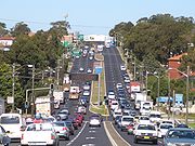
. In its previous incarnations, it was Ring Road 3 from 1964 to 1974 and State Route 33 from 1974 until 1993. It is the main thoroughfare for the inner western suburbs and the Northern Beaches and links them to all major arterials. It does not have any stretch of freeway and is very congested during peak hours, especially on the 2 lane sections of road.
It was upgraded to 3 lanes in each direction during the late 1970s & 1980s, between North St Ives, and the M5 Motorway at Beverly Hills. It remains, however, 2 lanes in each direction between Beverley Hills and South Hurstville at the southern end, and between St Ives and Terrey Hills to the north. From Terrey Hills to its northern termination at Mona Vale, it is mostly 1 lane in each direction. It is not known when the widening to 3 lanes between Beverley Hills and South Hurstville will be completed as the previous preparations for this, ie. Houses moved back from roadway and road reservations (empty blocks of land) were made but no continuance to the project was made.
It goes under the Pacific Highway
Pacific Highway (Australia)
The Pacific Highway is a major transport route along part of the east coast of Australia and is part of Australia's national route 1.It is 960 km long and links Sydney, the capital of New South Wales, to Brisbane, the capital of Queensland, along the coast, via Gosford, Newcastle, Taree, Port...
(Metroad 1
Metroad 1
Metroad 1 is a Metroad in Sydney, New South Wales, Australia. It replaced National Route 1, from Metroad 7 at Pearces Corner in Wahroonga south-east to the CBD then from the CBD south-west to the F6 Southern Freeway at Waterfall in October 1993.-Route:...
) at Pymble
Pymble, New South Wales
Pymble is a suburb on the Upper North Shore of Sydney in the state of New South Wales, Australia. Pymble is located north-west of the Sydney Central Business District in the local government area of Ku-ring-gai Council....
(grade separation completed in 1989), M2 Hills Motorway
M2 Hills Motorway
The M2 Hills Motorway is a motorway in north-western Sydney, New South Wales, Australia. It forms part of Sydney Metroad 2 and the 110 km Sydney Orbital Network. West of Pennant Hills Road, the M2 is also part of the National Highway.-History:Previously, Sydney's western suburbs were poorly served...
(Metroad 2) at Macquarie Park
Macquarie Park, New South Wales
Macquarie Park is a suburb in northern Sydney, in the state of New South Wales, Australia. Macquarie Park is located 12 kilometres north-west of the Sydney central business district in the local government area of the City of Ryde...
, M4 Western Motorway
M4 Western Motorway
The M4 Western Motorway,, is a motorway in central Sydney, New South Wales, Australia...
(Metroad 4
Metroad 4
Metroad 4 is a Metroad in Sydney, New South Wales, Australia. It connects the inner-west of Sydney with the outer western suburbs. It mostly follows what was previously National Highway 32 from the Western Distributor in the CBD, west to the Great Western Highway at Lapstone...
) at Homebush
Homebush, New South Wales
Homebush is an inner western suburb of Sydney, in the state of New South Wales, Australia. Homebush is located 15 kilometres west of the Sydney central business district, in the local government area of the Municipality of Strathfield. Homebush West and Homebush Bay are separate suburbs...
and M5 South Western Motorway
M5 South Western Motorway
The M5 South Western Motorway is a privately operated tolled motorway in south-western Sydney, New South Wales, Australia. It forms part of Sydney Metroad 5 and the Sydney Orbital Network...
(Metroad 5) at Beverly Hills
Beverly Hills, New South Wales
Beverly Hills is a suburb in southern Sydney, in the state of New South Wales, Australia. Beverly Hills is located 17 kilometres south of the Sydney central business district and is part of the St George area. Beverly Hills lies across two local government areas, the City of Hurstville and the...
. It terminates at the Princes Highway
Princes Highway
The Princes Highway extends from Sydney to Port Augusta via the coast through the states of New South Wales, Victoria and South Australia, a distance of 1941 km or 1898 km via the former alignments of the highway ....
junction at Blakehurst. King Georges Road
King Georges Road, Sydney
thumb|right|80px|Metroad 3 markerKing Georges Road is an arterial road in Sydney, Australia, running through the local government areas of the Municipality of Kogarah, City of Hurstville and City of Canterbury....
is a major section of this route from Blakehurst to Wiley Park.
It is believed that this route will be known as the A3 when alphanumerical road numbering is introduced in New South Wales
New South Wales
New South Wales is a state of :Australia, located in the east of the country. It is bordered by Queensland, Victoria and South Australia to the north, south and west respectively. To the east, the state is bordered by the Tasman Sea, which forms part of the Pacific Ocean. New South Wales...
in the near future.
Metroad Suburbs
- Mona Vale
- St. Ives
- Pymble
- West Pymble
- Macquarie Park
- North Ryde
- Ryde
- Rhodes
- Liberty Grove
- Sydney Olympic Park (formerly Homebush Bay)
- Homebush West (Flemington)
- Wiley Park
- Beverly Hills
- Hurstville
- Blakehurst