

Menchum River
Encyclopedia
Cameroon
Cameroon, officially the Republic of Cameroon , is a country in west Central Africa. It is bordered by Nigeria to the west; Chad to the northeast; the Central African Republic to the east; and Equatorial Guinea, Gabon, and the Republic of the Congo to the south. Cameroon's coastline lies on the...
.
It in turn is a tributary of the Benue River
Benue River
The Benue River is the major tributary of the Niger River. The river is approximately 1,400 km long and is almost entirely navigable during the summer months...
in Nigeria
Nigeria
Nigeria , officially the Federal Republic of Nigeria, is a federal constitutional republic comprising 36 states and its Federal Capital Territory, Abuja. The country is located in West Africa and shares land borders with the Republic of Benin in the west, Chad and Cameroon in the east, and Niger in...
.
Location
The Menchum, DongaDonga River
The Donga River is a river in Nigeria and Cameroon. The river arises from the Mambilla Plateau in southeastern Nigeria, forms part of the international border between Nigeria and Cameroon, and flows northwest to eventually merge with the Benue River in Nigeria....
and Katsina Ala rivers all flow west from the Northeast Region to join the Benue in Nigeria.
The Menchum drains the Oku-Kom highlands, which have an elevation of 2400 metres (7,874 ft) around Lake Oku
Lake Oku
Lake Oku is a crater lake on the Bamenda Plateau in the Northwest Region of Cameroon. It is located at on Mount Oku, and is completely surrounded by cloud forest....
, falling to about 800 metres (2,624.7 ft) at Mbonkissu to the west of Fundong
Fundong
A new slang term used to describe freebies or gifts either monetary or non-monetaryFundong is a town and commune in Cameroon.-References:* * - Thèse de Donation Avele, Université Montesquieu Bordeaux IV * Charles Nanga, , Mémoire ENA....
. The highlands, formed by volcanic action, have been dissected by steep valleys carved out by fast-flowing streams.
Hydroelectric potential
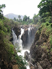
The Menchum Falls, about 20km south of WumWum
Wum is a town and commune in Cameroon. It is the capital of Menchum division in the Northwest Province.-Geography:Wum is the third biggest town in the North West Region of Cameroon. It lies on a plateau at an elevation of about 1100 m near the edge of the western highlands of Cameroon. It is north...
and 30km north of Bafut, are impressive and a potential tourist attraction. However, the access road is very rough, and the viewing site is not well maintained.
A 2003 guide stated that the road was virtually impassable in the rainy season.
On 7 September 2009, Agreenergy and the Government of Cameroon signed a Memorandum of Understanding for a project to build a dam and 90MW hydroelectric power plant on the river. Apart from bring electricity and jobs, the project would involve surfacing the road.
On 8 December 2010 President Paul Biya
Paul Biya
Paul Biya is a Cameroonian politician who has been the President of Cameroon since 6 November 1982. A native of Cameroon's south, Biya rose rapidly as a bureaucrat under President Ahmadou Ahidjo in the 1960s, serving as Secretary-General of the Presidency from 1968 to 1975 and then as Prime...
announced plans to construct a dam on the Menchum Falls.
Environmental issues
The rich volcanic soils in the highlands have attracted farmers and grazers, and the resulting land clearances have made the area vulnerable to soil erosion.The Menchum Valley is low-lying, and used to be covered in equatorial forests.
These have mostly been cleared for their timber, leaving open grassland that is used for grazing, and is subject to erosion on the slopes.
Efforts are being made to reforest the valley.