
Mechi Zone
Encyclopedia
Mechi
Mechi' onMouseout='HidePop("49468")' href="/topics/Zones_of_Nepal">zones of Nepal
. Its headquarters are at Ilam
. It comes under the Eastern Region of Nepal . The Indian state of Bihar
is to the south and Tibet
to the north. The largest town is Damak
in the Terai
. The majority of the population in Mechi are Kirantis (Limbu people
, Rai people
) and other ethnic groups like Koche and Meche, and hill castes like Bahun
and Chhetris.
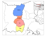
Mechi is divided into four districts:
Among the four districts Jhapa is in the Terai and it is highly developed. Ilam and Panchthar are in the hilly region. Ilam is also in a developing stage. Ilam is naturally very beautiful. Many tourists visit Ilam annually. Kanyam ia popular because of the tea garden. Antu is the place from where the rising sun can be viewed. Panchthar is the least developed of the four districts. Taplejung is in mountainous zone.
There are two airports in the Mechi zone, in Bhadrapur and in Taplejung.
Mechi' onMouseout='HidePop("49468")' href="/topics/Zones_of_Nepal">zones of Nepal
Zones of Nepal
Nepal is divided into 14 administrative zones , and 75 districts . The 14 administrative zones are grouped into five development regions...
. Its headquarters are at Ilam
Ilam, Nepal
Ilam is a municipality and tea-producing town in Nepal. It is in Ilam District which is in hilly Eastern Region of Nepal. It is famous for natural scenery and landscapes, tea production, and diverse agricultural economy.-Tea Production:...
. It comes under the Eastern Region of Nepal . The Indian state of Bihar
Bihar
Bihar is a state in eastern India. It is the 12th largest state in terms of geographical size at and 3rd largest by population. Almost 58% of Biharis are below the age of 25, which is the highest proportion in India....
is to the south and Tibet
Tibet
Tibet is a plateau region in Asia, north-east of the Himalayas. It is the traditional homeland of the Tibetan people as well as some other ethnic groups such as Monpas, Qiang, and Lhobas, and is now also inhabited by considerable numbers of Han and Hui people...
to the north. The largest town is Damak
Damak
Damak is a town and municipality in Jhapa District in the Mechi Zone of south-eastern Nepal. It is situated between the Ratuwa River in the east and the Mawa River in the west. As of 2001 census total population of city is 35,009...
in the Terai
Terai
The Terai is a belt of marshy grasslands, savannas, and forests located south of the outer foothills of the Himalaya, the Siwalik Hills, and north of the Indo-Gangetic Plain of the Ganges, Brahmaputra and their tributaries. The Terai belongs to the Terai-Duar savanna and grasslands ecoregion...
. The majority of the population in Mechi are Kirantis (Limbu people
Limbu people
The Yakthung or Limbu tribes and clans belong to the Kirati nation or to the Kirat confederation.They are indigenous to the hill and mountainous regions of east Nepal between the Arun and Mechi rivers to as far as Southern Tibet, Bhutan and Sikkim....
, Rai people
Rai people
The Rai are one of Nepal's most ancient indigenous ethnolinguistic groups. They were Raya meaning king. Once someone was recognized as a ruler then Hindus awarded the title Raja, Rai, Raya, Malla etc. When the king Pritivi Narayan Shah couldn't defeat Kirant king , he somehow took them in...
) and other ethnic groups like Koche and Meche, and hill castes like Bahun
Bahun
Bahun is a colloquial Nepali term for a member of the Pahari or "hill" Brahmin caste, who are traditionally educators, scholars and priests of Hinduism. They are also known as Barmu in Newari. By tradition—and by civil law until 1962—they represented the highest of the four Hindu...
and Chhetris.
Mechi is divided into four districts:
- Ilam DistrictIlam DistrictIlam district of 282,806. It is about 600 km from Kathmandu. The highest point is Sandakpur with an elevation of 3000m. Ilam attracts many researchers who come to study rare birds and the Red Panda...
- Jhapa DistrictJhapa DistrictJhapa District, a district of Mechi Zone, is one of the seventy-five districts of Nepal. The district, with Chandragadhi as its district headquarters, covers an area of 1,606 km² and has a population of 688,109.-Location:...
- Panchthar DistrictPanchthar DistrictPanchthar District of 202,056. Panchthar's majority population is that of Kirantis and other ethnic groups and hill castes.-Village Development Committees :*Aangna*Aangsarang*Aarubote*Ambarpur*Bharapa*Chilingdin*Chokmagu...
- Taplejung DistrictTaplejung DistrictTaplejung District of 134,698.The name Taplejung is derived from the words "Taple" and "Jung". Taple was the medieval Limbu King who used to rule the area and "Jung" in Limbu language means Fort. Literally, Taplejung means Fort of King Taple....
Among the four districts Jhapa is in the Terai and it is highly developed. Ilam and Panchthar are in the hilly region. Ilam is also in a developing stage. Ilam is naturally very beautiful. Many tourists visit Ilam annually. Kanyam ia popular because of the tea garden. Antu is the place from where the rising sun can be viewed. Panchthar is the least developed of the four districts. Taplejung is in mountainous zone.
There are two airports in the Mechi zone, in Bhadrapur and in Taplejung.
See also
- Zones of NepalZones of NepalNepal is divided into 14 administrative zones , and 75 districts . The 14 administrative zones are grouped into five development regions...
- Regions of NepalRegions of NepalNepal is divided into 14 administrative zones , which are divided into 75 districts . The 14 administrative zones are grouped into five development regions...
- Districts of NepalDistricts of NepalNepal's 14 administrative zones are subdivided into 75 districts . These districts are listed below, by zone...