
McMahons Point, New South Wales
Encyclopedia
McMahons Point is a harbourside suburb
on the lower North Shore
of Sydney
, New South Wales
, Australia
. McMahons Point is located 3 kilometres north of the Sydney central business district
, in the local government area of North Sydney Council
. McMahons Point sits on the peninsula flanked by Berrys Bay to the west and Lavender Bay to the east. The lower tip of the peninsula is known as Blues Point
, which offers expansive views of Port Jackson
(Sydney Harbour). The postcode is 2060.
Once predominantly working-class, it is now among Sydney's most exclusive localities. McMahons Point is primarily a medium- to high-density residential area and is bordered by the surrounding suburbs of Waverton
, North Sydney
and Lavender Bay
.
The original occupants of this region were the Cammeraygal
(or perhaps Quiberie as tribal affiliations seem to have been loose and amorphous). These people lived along the foreshores and in bushland, cliffs and rock shelters prior to European settlement.
Land in this area was originally settled and farmed by James Milson (1785-1872), a Napoleonic War veteran, in 1806. Further grants were subsequently made in 1817 to Billy Blue
, a Jamaican convict turned Sydney Harbour waterman, which remained within his family until the 1850s. Subsequently, the estate was progressively subdivided, with the earliest developments occurring on the northern end. Blues Point Road had been gazetted from 1839 as a thoroughfare from the ferry wharf to the St Leonards
township. Most of the middle and southern sections of the peninsula were subdivided by the 1870s. A tram line was extended to McMahons Point in 1909, further stimulating development, particularly along Blues Point Road.
Large numbers of passenger and vehicular ferries travelled between Blues Point/McMahons Point and the city at the turn of the century. When the Sydney Harbour Bridge opened in 1932, the wharves of McMahons and Blues point provided services every 10-15 minutes and served six million passengers per year. The opening of the harbour bridge immediately rendered the bulk of these ferries redundant and, in 1935, small ferries operated by Hegarty Ferries took over the former runs of the larger craft of Sydney Ferries Ltd to McMahons Point. The tram service was replaced by buses in 1933.
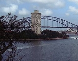
In July 1890, the boroughs of St Leonards, East St Leonards and Victoria (incorporating McMahons Point) merged to form the borough of North Sydney. Foreshores were popular for boat building and other maritime activity through the latter half of the nineteenth century and well into the twentieth. In 1957, much of McMahons Point was to be rezoned as 'waterfront industrial' by North Sydney Council, but a group formed by residents and architects, led by Harry Seidler
, argued for a residential vision. Seidler proposed a 29-building apartment development in gardens. This redevelopment was in turn opposed by a new council and residents; only two towers were built - Blues Point Tower http://www.smh.com.au/articles/2002/09/27/1032734319538.html and Harbour Master.
A stretch of railway line dating from 1893 runs through the suburb's north-west and emerges from a tunnel at an off-peak storage depot in Lavender Bay. It no longer carries passengers as a newer line (known now as the North Shore railway line) was constructed in 1932 which traverses the North Sydney and Milsons Point
stations.
for harbour ferry services and the railway (from Waverton, North Sydney and Milson's Point) on the North Shore line of the City Rail network.
Suburb
The word suburb mostly refers to a residential area, either existing as part of a city or as a separate residential community within commuting distance of a city . Some suburbs have a degree of administrative autonomy, and most have lower population density than inner city neighborhoods...
on the lower North Shore
North Shore (Sydney)
The North Shore is an informal term used to describe the primarily residential area of northern metropolitan Sydney, in the state of New South Wales, Australia. The term usually refers to the suburbs located on the north shore of Sydney Harbour between Middle Harbour and the Lane Cove River, up to...
of Sydney
Sydney
Sydney is the most populous city in Australia and the state capital of New South Wales. Sydney is located on Australia's south-east coast of the Tasman Sea. As of June 2010, the greater metropolitan area had an approximate population of 4.6 million people...
, New South Wales
New South Wales
New South Wales is a state of :Australia, located in the east of the country. It is bordered by Queensland, Victoria and South Australia to the north, south and west respectively. To the east, the state is bordered by the Tasman Sea, which forms part of the Pacific Ocean. New South Wales...
, Australia
Australia
Australia , officially the Commonwealth of Australia, is a country in the Southern Hemisphere comprising the mainland of the Australian continent, the island of Tasmania, and numerous smaller islands in the Indian and Pacific Oceans. It is the world's sixth-largest country by total area...
. McMahons Point is located 3 kilometres north of the Sydney central business district
Sydney central business district
The Sydney central business district is the main commercial centre of Sydney, New South Wales, Australia. It extends southwards for about 3 kilometres from Sydney Cove, the point of first European settlement. Its north–south axis runs from Circular Quay in the north to Central railway station in...
, in the local government area of North Sydney Council
North Sydney Council
North Sydney Council is a Local Government Area on the North Shore of Sydney, in the state of New South Wales, Australia.- Demographics :According to the :...
. McMahons Point sits on the peninsula flanked by Berrys Bay to the west and Lavender Bay to the east. The lower tip of the peninsula is known as Blues Point
Blues Point
Blues Point is a harbourside locality of North Sydney, Australia. Named after local mariner Billy Blue in the 19th century, Blues Point is at the very southern tip of the McMahons Point peninsula and has spectacular views of Sydney Harbour. The locality, within North Sydney Council, is home to the...
, which offers expansive views of Port Jackson
Port Jackson
Port Jackson, containing Sydney Harbour, is the natural harbour of Sydney, Australia. It is known for its beauty, and in particular, as the location of the Sydney Opera House and Sydney Harbour Bridge...
(Sydney Harbour). The postcode is 2060.
Once predominantly working-class, it is now among Sydney's most exclusive localities. McMahons Point is primarily a medium- to high-density residential area and is bordered by the surrounding suburbs of Waverton
Waverton, New South Wales
Waverton is a suburb on the lower North Shore of Sydney, New South Wales, Australia. Waverton is located 4 kilometres north of the Sydney central business district, in the local government area of North Sydney Council.-History:...
, North Sydney
North Sydney, New South Wales
North Sydney is a suburb and commercial district on the Lower North Shore of Sydney, in the state of New South Wales, Australia. North Sydney is located 3 kilometres north of the Sydney central business district and is the administrative centre for the local government area of North Sydney...
and Lavender Bay
Lavender Bay, New South Wales
Lavender Bay is a harbourside suburb on the lower North Shore of Sydney, New South Wales, Australia. Lavender Bay is located 3 kilometres north of the Sydney central business district, in the local government area of North Sydney Council....
.
History
McMahons Point is named after Maurice McMahon, an Irish manufacturer of brushes and combs who, in 1864, built his home on the headland. He became mayor of the borough of Victoria (later North Sydney) in 1890.The original occupants of this region were the Cammeraygal
Cammeraygal
The Cammeraygal are an Indigenous Australian people that inhabited the Lower North Shore area of the present-day North Sydney Council in Sydney, Australia....
(or perhaps Quiberie as tribal affiliations seem to have been loose and amorphous). These people lived along the foreshores and in bushland, cliffs and rock shelters prior to European settlement.
Land in this area was originally settled and farmed by James Milson (1785-1872), a Napoleonic War veteran, in 1806. Further grants were subsequently made in 1817 to Billy Blue
Billy Blue
Billy Blue or William Blue was an Australian convict. Although Billy Blue’s place and date of birth are uncertain, convict records suggest he was born in Jamaica around 1767.-Conviction:...
, a Jamaican convict turned Sydney Harbour waterman, which remained within his family until the 1850s. Subsequently, the estate was progressively subdivided, with the earliest developments occurring on the northern end. Blues Point Road had been gazetted from 1839 as a thoroughfare from the ferry wharf to the St Leonards
St Leonards, New South Wales
St Leonards is a suburb on the lower North Shore of Sydney, in the state of New South Wales, Australia. St Leonards is located 5 km north-west of the Sydney central business district and lies across the local government areas of Municipality of Lane Cove, North Sydney Council and the City of...
township. Most of the middle and southern sections of the peninsula were subdivided by the 1870s. A tram line was extended to McMahons Point in 1909, further stimulating development, particularly along Blues Point Road.
Large numbers of passenger and vehicular ferries travelled between Blues Point/McMahons Point and the city at the turn of the century. When the Sydney Harbour Bridge opened in 1932, the wharves of McMahons and Blues point provided services every 10-15 minutes and served six million passengers per year. The opening of the harbour bridge immediately rendered the bulk of these ferries redundant and, in 1935, small ferries operated by Hegarty Ferries took over the former runs of the larger craft of Sydney Ferries Ltd to McMahons Point. The tram service was replaced by buses in 1933.
In July 1890, the boroughs of St Leonards, East St Leonards and Victoria (incorporating McMahons Point) merged to form the borough of North Sydney. Foreshores were popular for boat building and other maritime activity through the latter half of the nineteenth century and well into the twentieth. In 1957, much of McMahons Point was to be rezoned as 'waterfront industrial' by North Sydney Council, but a group formed by residents and architects, led by Harry Seidler
Harry Seidler
Harry Seidler, AC OBE was an Austrian-born Australian architect who is considered to be one of the leading exponents of Modernism's methodology in Australia and the first architect to fully express the principles of the Bauhaus in Australia.Harry Seidler designed more than 180 buildings and he...
, argued for a residential vision. Seidler proposed a 29-building apartment development in gardens. This redevelopment was in turn opposed by a new council and residents; only two towers were built - Blues Point Tower http://www.smh.com.au/articles/2002/09/27/1032734319538.html and Harbour Master.
A stretch of railway line dating from 1893 runs through the suburb's north-west and emerges from a tunnel at an off-peak storage depot in Lavender Bay. It no longer carries passengers as a newer line (known now as the North Shore railway line) was constructed in 1932 which traverses the North Sydney and Milsons Point
Milsons Point, New South Wales
Milsons Point is a suburb on the lower North Shore of Sydney, in the state of New South Wales, Australia. North Sydney is located 3 kilometres north of the Sydney central business district in the local government area of North Sydney Council....
stations.
Commercial area
At the northern end of Blues Point Road (adjacent to the North Sydney central business district) there is a concentration of businesses primarily associated with advertising/marketing, publishing, media, computing, engineering, architecture and creative arts. This precinct is also home to many al fresco street cafés and restaurants and some speciality retail stores.Transport
The suburb is served by a ferryFerry
A ferry is a form of transportation, usually a boat, but sometimes a ship, used to carry primarily passengers, and sometimes vehicles and cargo as well, across a body of water. Most ferries operate on regular, frequent, return services...
for harbour ferry services and the railway (from Waverton, North Sydney and Milson's Point) on the North Shore line of the City Rail network.
External links
- http://www.mcmahons-point.com.au