
McKnight Mountain
Encyclopedia
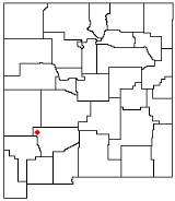
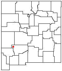
McKnight Mountain is the highest peak in the Black Range
of southwestern New Mexico
, in the southwestern United States
. It is located about 30 miles (48 km) northeast of Silver City
, in the Aldo Leopold Wilderness
of the Gila National Forest
.
The mountain is topped by a flat ridge running roughly north-south for about one-half mile; the north and south ends of the ridge are both listed at 10,165 feet. The mountain is forested up to near its summit, which is rocky and provides panoramic views. Its west slopes are the headwaters of the East Fork of the Mimbres River
, which flows through McKnight Canyon, and its northwest slopes also feed into the Mimbres. The east side is drained by Las Animas Creek, which flows into the Rio Grande
at Caballo Reservoir. While the Continental Divide
runs along much of the Black Range, McKnight Mountain is not on the divide itself, which separates from the crest of the Black Range at Red Peak a few miles to the north.
McKnight Mountain is accessible via several trails. One is Trail 79, which runs along the crest of the Black Range, with a trailhead about 5 miles (8 km) miles south of the peak, located near McKnight Cabin at the end of Forest Road 152. Another, Trail 82, approaches the peak from the west through McKnight Canyon.
Black Range
The Black Range is an igneous mountain range running north-south in Sierra and Grant counties in west-central New Mexico, in the southwestern United States. Its central ridge forms the western and eastern borders, respectively, of the two counties through much of their contact...
of southwestern New Mexico
New Mexico
New Mexico is a state located in the southwest and western regions of the United States. New Mexico is also usually considered one of the Mountain States. With a population density of 16 per square mile, New Mexico is the sixth-most sparsely inhabited U.S...
, in the southwestern United States
United States
The United States of America is a federal constitutional republic comprising fifty states and a federal district...
. It is located about 30 miles (48 km) northeast of Silver City
Silver City, New Mexico
Silver City is a town in Grant County, New Mexico, in the United States. As of the 2000 census, the town population was 10,545. It is the county seat of Grant County. The city is the home of Western New Mexico University.-History:...
, in the Aldo Leopold Wilderness
Aldo Leopold Wilderness
Aldo Leopold Wilderness, along with Gila Wilderness and Blue Range Wilderness, is part of New Mexico's Gila National Forest. It became part of the National Wilderness Preservation System in 1980 by an act of the United States Congress and has a total of...
of the Gila National Forest
Gila National Forest
The Gila National Forest is a protected national forest in New Mexico in the southwestern United States established in 1905. It covers approximately 3.3 million acres of public land, making it the sixth largest National Forest in the continental United States...
.
The mountain is topped by a flat ridge running roughly north-south for about one-half mile; the north and south ends of the ridge are both listed at 10,165 feet. The mountain is forested up to near its summit, which is rocky and provides panoramic views. Its west slopes are the headwaters of the East Fork of the Mimbres River
Mimbres River
The Mimbres River is a river in southwestern New Mexico. It forms from snow pack and runoff on the south-western slopes of the Black Range and flows into a small endorheic basin east of Deming, New Mexico. The uplands watershed are administered by the US Forest Service, while the land in the...
, which flows through McKnight Canyon, and its northwest slopes also feed into the Mimbres. The east side is drained by Las Animas Creek, which flows into the Rio Grande
Rio Grande
The Rio Grande is a river that flows from southwestern Colorado in the United States to the Gulf of Mexico. Along the way it forms part of the Mexico – United States border. Its length varies as its course changes...
at Caballo Reservoir. While the Continental Divide
Continental Divide
The Continental Divide of the Americas, or merely the Continental Gulf of Division or Great Divide, is the name given to the principal, and largely mountainous, hydrological divide of the Americas that separates the watersheds that drain into the Pacific Ocean from those river systems that drain...
runs along much of the Black Range, McKnight Mountain is not on the divide itself, which separates from the crest of the Black Range at Red Peak a few miles to the north.
McKnight Mountain is accessible via several trails. One is Trail 79, which runs along the crest of the Black Range, with a trailhead about 5 miles (8 km) miles south of the peak, located near McKnight Cabin at the end of Forest Road 152. Another, Trail 82, approaches the peak from the west through McKnight Canyon.