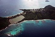
Mayreau
Encyclopedia

Grenadines
The Grenadines is a Caribbean island chain of over 600 islands in the Windward Islands.-Geographic boundaries:They are divided between the island nations of Saint Vincent and the Grenadines and Grenada. They lie between the islands of Saint Vincent in the north and Grenada in the south. Neither...
, with an area of about 1.5 sq. miles, and a population of about 300. The population is centered in Old Wall village, located on a hilltop in the southwest of the island. It is an isolated community, accessible only by boat. Electricity is only recently (2002) provided by a central generator. There is a single lane concrete road leading from Saltwhistle Bay to Saline Bay and through the village. The top of the island is crested with the small school, the telecommunications building and the Mayreau Catholic Church and a Pentecostal church. The island gets much of its water from three catchments set on the east side of the island. One serves the resort at Saltwhistle, and two serve the village. Saline Bay is named for the salt pond just east of the sandy beach. Salt was harvested and exported in times past but is now only harvested for local use. The island is mostly populated by fishermen and supported by tourism. The school has about 50 students in Grades 1-6. Upon completing their primary / elementary education, students attend secondary schools on the main island, St. Vincent. Mayreau also has a small resort area on Saltwhistle Bay. Saltwhistle Bay is also a very popular and beautiful spot for anchoring yachts.
From the crest of the hill beside the Catholic Church, there is a beautiful overlook of the Tobago Cays
Tobago Cays
The Tobago Cays are an archipelago comprising five small uninhabited islands - Petit Rameau, Petit Bateau, Baradol, Petit Tobac and Jamesby - located in the Southern Grenadines. The Tobago Cays are now the key element of the Tobago Cays Marine Park, a national park and wildlife preserve run by the...
, Canouan
Canouan
Canouan is an island in the Grenadines Islands belonging to St Vincent. It is a tiny island, measuring only 3.5 miles by 1.25 miles.A barrier reef runs along the Atlantic side of the island. The highest point on the island is Mount Royal. Two bays, Glossy and Friendship, separate the southern side...
and Union Island
Union Island
Union Island is part of the nation of St. Vincent and the Grenadines. It the southernmost island of the Grenadines. It lies 90 kilometers southwest of Barbados and is within view of the islands of Carriacou and the mainland of Grenada, which lie directly south.Clifton and Ashton are the two...
.

