
Mattituck, New York
Encyclopedia
Mattituck is a census-designated place
in Suffolk County
, New York
, United States. The population was 4,198 at the 2000 census.
Mattituck CDP roughly corresponds to the hamlet (unincorporated community) by the same name in the town of Southold.
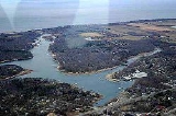
name for the "Great Creek.". The Mattituck Creek has been dredged and is used extensively by pleasure craft on Long Island Sound
(the Mattituck Inlet is the entrance into Mattituck Creek and the whole waterway is now popularly referred to as Mattituck Inlet).
It is only one of two harbors (other being Mt. Sinai harbor) on the north side of Long Island on the Sound east of Port Jefferson, New York
The Mattituck Inlet and James Creek (which has also been dredged for boats) on the Peconic Bay
come within 500 yards of each other and would provide a shortcut between the Peconic and Sound through the North Fork if connected via a canal. However authorities have resisted the connection fearing an ecological disaster. Still the inlet is blamed for coastal erosion because it interrupts the longshore drift
on the sound.
The area was originally settled by English
colonists. Corchaug Indians, who were the first residents of the area, sold land to Theophilus Eaton, governor of New Haven, CT. The meadowlands were held in common by the residents of Southold from its founding in 1640. The Township of Southold was established by Charter to the New Haven Colony of Connecticut in 1658. The woodlands were also held in common until 1661 when that land was divided among individual proprietors.
Mattituck hosts an annual Strawberry Festival and is located in the heart of over 30 vineyards in the Long Island Wine Region.
, the community has a total area of 10.2 square miles (26.5 km²), of which, 8.6 square miles (22.4 km²) of it is land and 1.6 square miles (4.1 km²) of it (15.53%) is water.
of 2000, there were 4,198 people, 1,651 households, and 1,231 families residing in the CDP. The population density
was 485.7 per square mile (187.6/km²). There were 2,313 housing units at an average density of 267.6/sq mi (103.4/km²). The racial makeup of the hamlet was 96.62% White, 1.17% African American, 0.02% Native American, 0.52% Asian, 0.64% from other races
, and 1.02% from two or more races. Hispanic or Latino of any race were 2.55% of the population.
There were 1,651 households out of which 31.9% had children under the age of 18 living with them, 62.4% were married couples
living together, 9.4% had a female householder with no husband present, and 25.4% were non-families. 21.8% of all households were made up of individuals and 12.2% had someone living alone who was 65 years of age or older. The average household size was 2.53 and the average family size was 2.97.
In the community the population was spread out with 23.2% under the age of 18, 5.6% from 18 to 24, 25.0% from 25 to 44, 27.1% from 45 to 64, and 19.1% who were 65 years of age or older. The median age was 42 years. For every 100 females there were 92.9 males. For every 100 females age 18 and over, there were 88.9 males.
The median income for a household in the hamlet was $55,353, and the median income for a family was $63,370. Males had a median income of $42,917 versus $34,813 for females. The per capita income
for the CDP was $26,101. About 4.5% of families and 5.6% of the population were below the poverty line, including 5.7% of those under age 18 and 9.6% of those age 65 or over.
Mattituck-Cutchogue Union Free School District
is attended by residents of Mattituck, Cutchogue and Laurel
. The sports team name is the Tuckers.
Census-designated place
A census-designated place is a concentration of population identified by the United States Census Bureau for statistical purposes. CDPs are delineated for each decennial census as the statistical counterparts of incorporated places such as cities, towns and villages...
in Suffolk County
Suffolk County, New York
Suffolk County is a county located in the U.S. state of New York on the eastern portion of Long Island. As of the 2010 census, the population was 1,493,350. It was named for the county of Suffolk in England, from which its earliest settlers came...
, New York
New York
New York is a state in the Northeastern region of the United States. It is the nation's third most populous state. New York is bordered by New Jersey and Pennsylvania to the south, and by Connecticut, Massachusetts and Vermont to the east...
, United States. The population was 4,198 at the 2000 census.
Mattituck CDP roughly corresponds to the hamlet (unincorporated community) by the same name in the town of Southold.
History
It is believed to have derived its name for the Native AmericanIndigenous peoples of the Americas
The indigenous peoples of the Americas are the pre-Columbian inhabitants of North and South America, their descendants and other ethnic groups who are identified with those peoples. Indigenous peoples are known in Canada as Aboriginal peoples, and in the United States as Native Americans...
name for the "Great Creek.". The Mattituck Creek has been dredged and is used extensively by pleasure craft on Long Island Sound
Long Island Sound
Long Island Sound is an estuary of the Atlantic Ocean, located in the United States between Connecticut to the north and Long Island, New York to the south. The mouth of the Connecticut River at Old Saybrook, Connecticut, empties into the sound. On its western end the sound is bounded by the Bronx...
(the Mattituck Inlet is the entrance into Mattituck Creek and the whole waterway is now popularly referred to as Mattituck Inlet).
It is only one of two harbors (other being Mt. Sinai harbor) on the north side of Long Island on the Sound east of Port Jefferson, New York
Port Jefferson, New York
The Incorporated Village of Port Jefferson is located in the town of Brookhaven in Suffolk County, New York on the North Shore of Long Island. As of the 2000 United States Census, the village population was 7,837...
The Mattituck Inlet and James Creek (which has also been dredged for boats) on the Peconic Bay
Peconic Bay
The Peconic Bay is the parent name for two bays between the North Fork and South Fork of Long Island in the U.S. state of New York. It is separated from Gardiners Bay by Shelter Island....
come within 500 yards of each other and would provide a shortcut between the Peconic and Sound through the North Fork if connected via a canal. However authorities have resisted the connection fearing an ecological disaster. Still the inlet is blamed for coastal erosion because it interrupts the longshore drift
Longshore drift
Longshore drift consists of the transportation of sediments along a coast at an angle to the shoreline, which is dependent on prevailing wind direction, swash and backwash. This process occurs in the littoral zone, and in or within close proximity to the surf zone...
on the sound.
The area was originally settled by English
England
England is a country that is part of the United Kingdom. It shares land borders with Scotland to the north and Wales to the west; the Irish Sea is to the north west, the Celtic Sea to the south west, with the North Sea to the east and the English Channel to the south separating it from continental...
colonists. Corchaug Indians, who were the first residents of the area, sold land to Theophilus Eaton, governor of New Haven, CT. The meadowlands were held in common by the residents of Southold from its founding in 1640. The Township of Southold was established by Charter to the New Haven Colony of Connecticut in 1658. The woodlands were also held in common until 1661 when that land was divided among individual proprietors.
Mattituck hosts an annual Strawberry Festival and is located in the heart of over 30 vineyards in the Long Island Wine Region.
Geography
According to the United States Census BureauUnited States Census Bureau
The United States Census Bureau is the government agency that is responsible for the United States Census. It also gathers other national demographic and economic data...
, the community has a total area of 10.2 square miles (26.5 km²), of which, 8.6 square miles (22.4 km²) of it is land and 1.6 square miles (4.1 km²) of it (15.53%) is water.
Demographics
As of the censusCensus
A census is the procedure of systematically acquiring and recording information about the members of a given population. It is a regularly occurring and official count of a particular population. The term is used mostly in connection with national population and housing censuses; other common...
of 2000, there were 4,198 people, 1,651 households, and 1,231 families residing in the CDP. The population density
Population density
Population density is a measurement of population per unit area or unit volume. It is frequently applied to living organisms, and particularly to humans...
was 485.7 per square mile (187.6/km²). There were 2,313 housing units at an average density of 267.6/sq mi (103.4/km²). The racial makeup of the hamlet was 96.62% White, 1.17% African American, 0.02% Native American, 0.52% Asian, 0.64% from other races
Race (United States Census)
Race and ethnicity in the United States Census, as defined by the Federal Office of Management and Budget and the United States Census Bureau, are self-identification data items in which residents choose the race or races with which they most closely identify, and indicate whether or not they are...
, and 1.02% from two or more races. Hispanic or Latino of any race were 2.55% of the population.
There were 1,651 households out of which 31.9% had children under the age of 18 living with them, 62.4% were married couples
Marriage
Marriage is a social union or legal contract between people that creates kinship. It is an institution in which interpersonal relationships, usually intimate and sexual, are acknowledged in a variety of ways, depending on the culture or subculture in which it is found...
living together, 9.4% had a female householder with no husband present, and 25.4% were non-families. 21.8% of all households were made up of individuals and 12.2% had someone living alone who was 65 years of age or older. The average household size was 2.53 and the average family size was 2.97.
In the community the population was spread out with 23.2% under the age of 18, 5.6% from 18 to 24, 25.0% from 25 to 44, 27.1% from 45 to 64, and 19.1% who were 65 years of age or older. The median age was 42 years. For every 100 females there were 92.9 males. For every 100 females age 18 and over, there were 88.9 males.
The median income for a household in the hamlet was $55,353, and the median income for a family was $63,370. Males had a median income of $42,917 versus $34,813 for females. The per capita income
Per capita income
Per capita income or income per person is a measure of mean income within an economic aggregate, such as a country or city. It is calculated by taking a measure of all sources of income in the aggregate and dividing it by the total population...
for the CDP was $26,101. About 4.5% of families and 5.6% of the population were below the poverty line, including 5.7% of those under age 18 and 9.6% of those age 65 or over.
Mattituck-Cutchogue Union Free School District
Mattituck-Cutchogue Union Free School District
Mattituck-Cutchogue Union Free School District is a public school district located on the North Fork of Long Island, in Suffolk County, New York, United States...
is attended by residents of Mattituck, Cutchogue and Laurel
Laurel, New York
Laurel is a census-designated place roughly corresponding to the hamlet in Suffolk County, New York, United States. It is in the towns of Southold and Riverhead. The population was 1,188 at the 2000 census.- History :...
. The sports team name is the Tuckers.