
Massachusetts Route 145
Encyclopedia
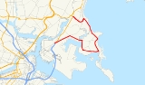
Route 145 is a circuitous south–north urban state highway
in Massachusetts
. It is entirely within Suffolk County
and primarily serves the peninsular town of Winthrop
from East Boston
and Revere
.
/I-90
ends and becomes Route 1A
. An access road from the Mass Pike/Route 1A junction travels a short distance on Neptune Road to Bennington Street, with a right turn onto Bennington Street marking the beginning of Route 145. Route 145 travels northeast along this major arterial street to the Orient Heights neighborhood and then bears right along Saratoga Street at Orient Heights Square. The route continues along Saratoga Street east until crossing into Winthrop over a bridge at Belle Isle Inlet.
Route 145 travels a short distance down Main Street in Winthrop before turning right and traveling nearly due south along Pleasant Street. This residential section of Winthrop features Donovan's Beach which offers a view of the Boston skyline looking west-southwest across Logan Airport. Pleasant Street continues south then bears left a few times before becoming Washington Avenue, where Route 145 travels east to meet Veterans Road. At this intersection, Route 145 heads north along Veterans Road while traffic heading for Point Shirley and Deer Island
continues to Shirley Street. Along Veterans Road the route heads north through Winthrop and then bears left at the intersection with the north end of Winthrop Shore Drive to become Crest Avenue and then Revere Street, heading generally northwest.
Leaving Winthrop, Route 145 enters Revere and is called Winthrop Parkway, which travels north along the Atlantic Ocean past Revere's Beachmont
neighborhood and meets Revere Beach Parkway at Eliot Circle. From the circle Route 145 travels south then west as the beginning of the westbound parkway. Technically the route ends as the parkway crosses under Route 1A after passing the Suffolk Downs
area and travels less than 1000 feet (304.8 m) to meet Route 16
.
 Modern Route 145 was first commissioned between 1954 and 1956 as Route 45. The route was renumbered to 145 in 1958.
State highway
State highway, state road or state route can refer to one of three related concepts, two of them related to a state or provincial government in a country that is divided into states or provinces :#A...
in Massachusetts
Massachusetts
The Commonwealth of Massachusetts is a state in the New England region of the northeastern United States of America. It is bordered by Rhode Island and Connecticut to the south, New York to the west, and Vermont and New Hampshire to the north; at its east lies the Atlantic Ocean. As of the 2010...
. It is entirely within Suffolk County
Suffolk County, Massachusetts
Suffolk County has no land border with Plymouth County to its southeast, but the two counties share a water boundary in the middle of Massachusetts Bay.-National protected areas:*Boston African American National Historic Site...
and primarily serves the peninsular town of Winthrop
Winthrop, Massachusetts
The Town of Winthrop is a municipality in Suffolk County, Massachusetts, United States. The population of Winthrop was 17,497 at the 2010 U.S. Census. It is an oceanside suburban community in Greater Boston situated at the north entrance to Boston Harbor and is very close to Logan International...
from East Boston
East Boston, Massachusetts
East Boston is a neighborhood of Boston, Massachusetts, with approximately 40,000 residents. The community was created by connecting several islands using landfill and was annexed by Boston in 1836. East Boston is separated from the rest of the city by Boston Harbor and bordered by Winthrop,...
and Revere
Revere, Massachusetts
Revere is a city in Suffolk County, Massachusetts, United States, and located approximately from downtown Boston. It is named after the American patriot Paul Revere. As of the 2010 census, the city population was 51,755.- History :...
.
Route description
Although it is officially a south–north highway, Route 145 travels in each of the four main compass directions at some point along its route. Route 145 begins at the intersection of Neptune Road and Bennington Street in East Boston, just after the point where the Mass PikeMassachusetts Turnpike
The Massachusetts Turnpike is the easternmost stretch of Interstate 90. The Turnpike begins at the western border of Massachusetts in West Stockbridge connecting with the Berkshire Connector portion of the New York State Thruway...
/I-90
Interstate 90
Interstate 90 is the longest Interstate Highway in the United States at . It is the northernmost coast-to-coast interstate, and parallels US 20 for the most part. Its western terminus is in Seattle, at Edgar Martinez Drive S. near Safeco Field and CenturyLink Field, and its eastern terminus is in...
ends and becomes Route 1A
Massachusetts Route 1A
Route 1A is a south–north state highway in Massachusetts. It is an alternate route to U.S. 1 with three signed sections and two unsigned sections where the highway is concurrent with its parent...
. An access road from the Mass Pike/Route 1A junction travels a short distance on Neptune Road to Bennington Street, with a right turn onto Bennington Street marking the beginning of Route 145. Route 145 travels northeast along this major arterial street to the Orient Heights neighborhood and then bears right along Saratoga Street at Orient Heights Square. The route continues along Saratoga Street east until crossing into Winthrop over a bridge at Belle Isle Inlet.
Route 145 travels a short distance down Main Street in Winthrop before turning right and traveling nearly due south along Pleasant Street. This residential section of Winthrop features Donovan's Beach which offers a view of the Boston skyline looking west-southwest across Logan Airport. Pleasant Street continues south then bears left a few times before becoming Washington Avenue, where Route 145 travels east to meet Veterans Road. At this intersection, Route 145 heads north along Veterans Road while traffic heading for Point Shirley and Deer Island
Deer Island (Massachusetts)
Deer Island is a peninsula in Boston Harbor, Massachusetts. Since 1996 it is part of the Boston Harbor Islands National Recreation Area. Although still an island by name, Deer Island has been connected to the mainland since the former Shirley Gut channel, which once separated the island from the...
continues to Shirley Street. Along Veterans Road the route heads north through Winthrop and then bears left at the intersection with the north end of Winthrop Shore Drive to become Crest Avenue and then Revere Street, heading generally northwest.
Leaving Winthrop, Route 145 enters Revere and is called Winthrop Parkway, which travels north along the Atlantic Ocean past Revere's Beachmont
Beachmont, Massachusetts
Beachmont is a relatively insular community within Revere, Massachusetts and is referred to as the Capital of the city by locals. This Boston area neighborhood is diverse with some charming turn-of-the-century homes overlooking the Atlantic Ocean...
neighborhood and meets Revere Beach Parkway at Eliot Circle. From the circle Route 145 travels south then west as the beginning of the westbound parkway. Technically the route ends as the parkway crosses under Route 1A after passing the Suffolk Downs
Suffolk Downs
Suffolk Downs, a thoroughbred race track in East Boston, Massachusetts, United States opened in 1935. Famous horses that have raced at this track include Seabiscuit, Whirlaway, Funny Cide and Cigar. The MassCap is held there, as well at the annual Hot Dog Safari...
area and travels less than 1000 feet (304.8 m) to meet Route 16
Massachusetts Route 16
Route 16 is an east–west state highway in Massachusetts. It begins in the west at an intersection with Route 12 and Route 193 in Webster, just north of the Connecticut state border...
.
History