
Maryland Route 665
Encyclopedia
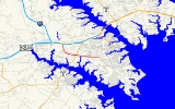
Maryland Route 665 is a state highway
in the U.S. state
of Maryland
. Known as Aris T. Allen Boulevard, the state highway runs 2.68 mi (4.3 km) from unsigned
Interstate 595
(I-595), U.S. Route 50
, and US 301
in Parole
east to Bywater Road and Forest Drive in Annapolis
.
. The state highway heads southeast as a four-lane freeway toward a single-point urban interchange
with Riva Road. MD 665 turns east and meets MD 2
(Solomons Island Road) at a partial cloverleaf interchange. Beyond MD 2, the state highway crosses Church Creek and becomes a four-lane divided highway with partial access control. After an intersection with Chinquapin Round Road, MD 665 reaches its eastern terminus at Bywater Road. The roadway continues southeast as Forest Drive toward the Bay Ridge area of Annapolis.
.
State highway
State highway, state road or state route can refer to one of three related concepts, two of them related to a state or provincial government in a country that is divided into states or provinces :#A...
in the U.S. state
U.S. state
A U.S. state is any one of the 50 federated states of the United States of America that share sovereignty with the federal government. Because of this shared sovereignty, an American is a citizen both of the federal entity and of his or her state of domicile. Four states use the official title of...
of Maryland
Maryland
Maryland is a U.S. state located in the Mid Atlantic region of the United States, bordering Virginia, West Virginia, and the District of Columbia to its south and west; Pennsylvania to its north; and Delaware to its east...
. Known as Aris T. Allen Boulevard, the state highway runs 2.68 mi (4.3 km) from unsigned
Unsigned highway
An unsigned highway is a highway that has been assigned a route number, but does not bear conventional road markings that would normally be used to identify the route with that number...
Interstate 595
Interstate 595 (Maryland)
Interstate 595 is an unsigned number for a section of the John Hanson Highway from Interstate 495 east of Washington, D.C. to Maryland Route 70 at Annapolis, Maryland....
(I-595), U.S. Route 50
U.S. Route 50 in Maryland
U.S. Route 50 is a major east–west route of the U.S. Highway system, stretching just over from Ocean City, Maryland on the Atlantic Ocean to West Sacramento, California. In the U.S. state of Maryland, US 50 exists in two sections. The longer of these serves as a major route connecting...
, and US 301
U.S. Route 301 in Maryland
U.S. Route 301 in Maryland is a major highway that runs from Delaware to the Governor Harry W. Nice Memorial Bridge into Virginia. It passes through three of Maryland's four main regions: the Eastern Shore, the Baltimore-Washington Metropolitan Area, and Southern Maryland...
in Parole
Parole, Maryland
Parole is a census-designated place in Anne Arundel County, Maryland, United States. The population was 14,031 at the 2000 census. It is where several major roads intersect at the edge of the state capital, Annapolis, and adjacent to the Annapolis Mall shopping center and Anne Arundel Medical Center...
east to Bywater Road and Forest Drive in Annapolis
Annapolis, Maryland
Annapolis is the capital of the U.S. state of Maryland, as well as the county seat of Anne Arundel County. It had a population of 38,394 at the 2010 census and is situated on the Chesapeake Bay at the mouth of the Severn River, south of Baltimore and about east of Washington, D.C. Annapolis is...
.
Route description
MD 665 begins at a directional interchange with unsigned I-595, US 50, and US 301 (John Hanson Highway) in Parole. The ramps from MD 665 tie into the ramps for I-97Interstate 97
Interstate 97 is an intrastate Interstate Highway located entirely within Anne Arundel County, Maryland, United States. It runs from Annapolis at the overlapped section of US 50, US 301, and the unsigned I-595 to Baltimore at the city's beltway...
. The state highway heads southeast as a four-lane freeway toward a single-point urban interchange
Single-point urban interchange
A single-point urban interchange , also called a single-point interchange or single-point diamond interchange , is a type of highway interchange...
with Riva Road. MD 665 turns east and meets MD 2
Maryland Route 2
Maryland Route 2 is the longest state highway in the U.S. state of Maryland. The route runs from Solomons Island in Calvert County north to an intersection with U.S. Route 1 and U.S. Route 40 Truck in Baltimore...
(Solomons Island Road) at a partial cloverleaf interchange. Beyond MD 2, the state highway crosses Church Creek and becomes a four-lane divided highway with partial access control. After an intersection with Chinquapin Round Road, MD 665 reaches its eastern terminus at Bywater Road. The roadway continues southeast as Forest Drive toward the Bay Ridge area of Annapolis.
Junction list
The entire route is in Anne Arundel CountyAnne Arundel County, Maryland
Anne Arundel County is a county located in the U.S. state of Maryland. It is named for Anne Arundell , a member of the ancient family of Arundells in Cornwall, England and the wife of Cæcilius Calvert, 2nd Baron Baltimore. Its county seat is Annapolis, which is also the capital of the state...
.
| Location | Mile |
Destinations | Notes |
|---|---|---|---|
| Parole Parole, Maryland Parole is a census-designated place in Anne Arundel County, Maryland, United States. The population was 14,031 at the 2000 census. It is where several major roads intersect at the edge of the state capital, Annapolis, and adjacent to the Annapolis Mall shopping center and Anne Arundel Medical Center... |
0.00 | – Washington Washington, D.C. Washington, D.C., formally the District of Columbia and commonly referred to as Washington, "the District", or simply D.C., is the capital of the United States. On July 16, 1790, the United States Congress approved the creation of a permanent national capital as permitted by the U.S. Constitution.... , Bay Bridge Chesapeake Bay Bridge The Chesapeake Bay Bridge is a major dual-span bridge in the U.S. state of Maryland. Spanning the Chesapeake Bay, it connects the state's rural Eastern Shore region with the more urban Western Shore. The original span opened in 1952 and, at the time, with a length of , it was the world's longest... , Baltimore, Richmond Richmond, Virginia Richmond is the capital of the Commonwealth of Virginia, in the United States. It is an independent city and not part of any county. Richmond is the center of the Richmond Metropolitan Statistical Area and the Greater Richmond area... |
Western terminus |
| 0.93 | Riva Road | Single-point urban interchange | |
| 1.56 | |||
| Annapolis Annapolis, Maryland Annapolis is the capital of the U.S. state of Maryland, as well as the county seat of Anne Arundel County. It had a population of 38,394 at the 2010 census and is situated on the Chesapeake Bay at the mouth of the Severn River, south of Baltimore and about east of Washington, D.C. Annapolis is... |
2.55 | Chinquapin Round Road north | Unsigned MD 665C |
| 2.68 | Forest Drive east / Bywater Road south | Eastern terminus |